
Robot autonomous navigation system based on double single-line laser radars

A laser radar and navigation system technology, applied in the field of robotics, can solve the problems of insufficient scanning range, short effective distance, and large noise interference, etc., to improve autonomous mobility and obstacle avoidance effects, improve utilization, Ease of Deployment

Active Publication Date: 2017-09-15
TONGJI UNIV
View PDF9 Cites 40 Cited by
  • Summary
  • Abstract
  • Description
  • Claims
  • Application Information

AI Technical Summary

Problems solved by technology

Although the solution of navigating through the first-line lidar can achieve path planning and obstacle avoidance by obtaining the two-dimensional outline of the environment, this solution can only scan and model the plane where the first-line radar is located. Obstacles on the scanning plane are powerless
Although stereo vision can be used to obtain three-dimensional environmental information, due to the limitation of the viewing angle of the camera, its scanning range cannot cover a sufficient spatial area, and this solution also has the disadvantages of large amount of data to be processed, large noise interference, and short effective distance.

Method used


Image

  • Robot autonomous navigation system based on double single-line laser radars
  • Robot autonomous navigation system based on double single-line laser radars
  • Robot autonomous navigation system based on double single-line laser radars

Examples


Embodiment Construction

[0018] The technical solutions of the present invention will be further introduced below in conjunction with the accompanying drawings and embodiments.

[0019] The first part introduces the principle of the technical solution:

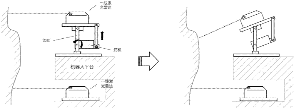
[0020] 1. Use two first-line laser radars and peripheral control circuits to form a dual-line radar system to collect environmental data. Such as figure 1 As shown, the two lidars are installed in different ways, one of which is fixed horizontally to obtain the plane outline of the space where the robot is located. The other radar scans up and down under the control of the radar controller powered by the steering gear 1, and the radar controller sends the angle information between the current radar scanning plane and the horizontal plane to the data processing system.

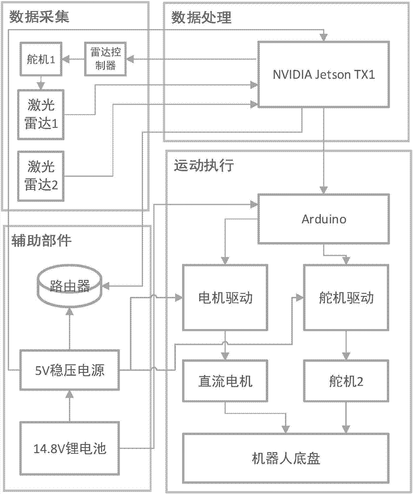
[0021] 2. Use the NVIDIA Jetson TX1 embedded platform as the core controller to build a robot hardware platform. The whole platform can be divided into four main parts according to...


PUM


Abstract

The invention realizes a new robot autonomous navigation system based on double single-line laser radars. Compared with mainstream indoor robot navigation systems in the prior art, only by use of two low-cost single-line laser radars as a source of information, navigation and obstacle avoidance effects of the new robot autonomous navigation system are obviously superior to that of schemes with same cost in the prior art. The new robot autonomous navigation system based on the double single-line laser radars includes a double single-line laser radar system, an upper navigation system, a bottom control algorithm and a motion execution system; the upper navigation system includes a SLAM algorithm and a coordinate transformation algorithm; a current space two-dimensional map can be dynamically constructed by use of original laser radar data acquired by horizontally-installed radars by use of the SLAM algorithm, and displacement information of a robot platform can be calculated.

Description

technical field [0001] The invention is an autonomous navigation solution applied to indoor robots, which belongs to the field of robots. technical background [0002] With the continuous development of computer technology and information processing technology, robot technology with these technologies as the core has also been widely used in various industries, including replacing manpower to complete tasks such as household services, patrols, and goods handling that are not complex but An indoor mobile robot that needs to work continuously in an indoor space. [0003] Navigation technology is one of the core technologies of mobile robots. In a complex and changeable indoor environment, a stable and effective navigation scheme is the key to determine whether the robot can complete its work. For mobile robot platforms that work in open outdoor spaces and do not require high precision, GPS can usually be used for positioning and navigation, but for mobile robots that work ind...

Claims


Application Information

Patent Timeline
IPC IPC(8): G01C21/20G01S17/93G05D1/02
CPCG01C21/20G01S17/93G05D1/0219G05D1/0257
Inventor 叶晨王建亮刘炀王仁为任秋宇
Owner TONGJI UNIV
Learn More