Road ground surface line data automatic generation system and method

An automatic generation and data processing system technology, applied in the field of surveying and mapping, can solve the problems of low accuracy of surveying and mapping results, increased survey costs, and difficulty in guaranteeing construction periods, and achieves the effect of saving field surveying costs, improving efficiency, and improving efficiency.

Pending Publication Date: 2017-09-15
SHANGHAI HUACE NAVIGATION TECH
View PDF7 Cites 9 Cited by
  • Summary
  • Abstract
  • Description
  • Claims
  • Application Information

AI Technical Summary

Problems solved by technology

However, this method uses single-point contact measurement, which leads to a slow operation speed. At the same time, due to the limitations of natural conditions such as weather, traffic, and diffi

Method used


Image

  • Road ground surface line data automatic generation system and method
  • Road ground surface line data automatic generation system and method

Examples


Embodiment Construction

[0035] In the following description, numerous specific details are given in order to provide a more thorough understanding of the present invention. It will be apparent, however, to one skilled in the art that the present invention may be practiced without one or more of these details. In other examples, some technical features known in the art are not described in order to avoid confusion with the present invention.

[0036] In order to thoroughly understand the present invention, detailed steps and detailed structures will be provided in the following description, so as to illustrate the technical solution of the present invention. Preferred embodiments of the present invention are described in detail below, however, the present invention may have other embodiments besides these detailed descriptions.

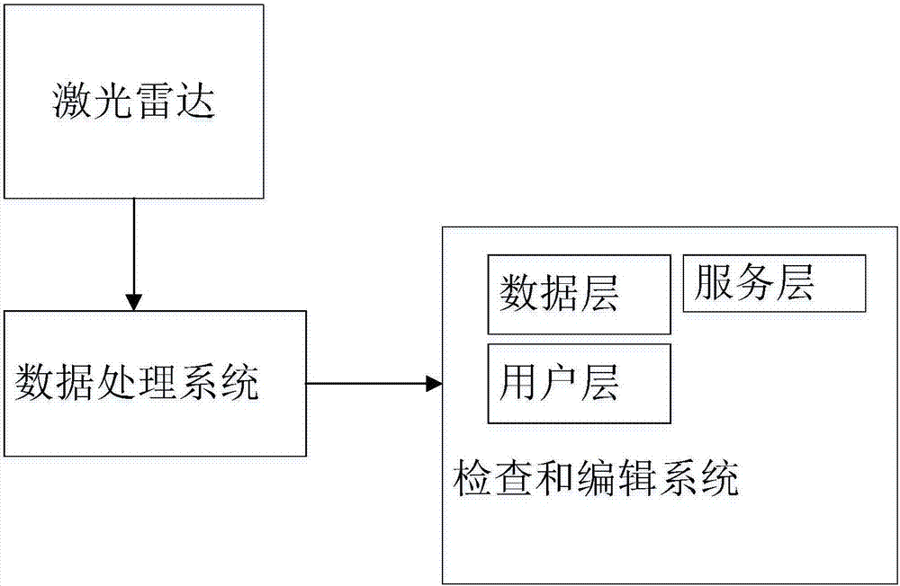
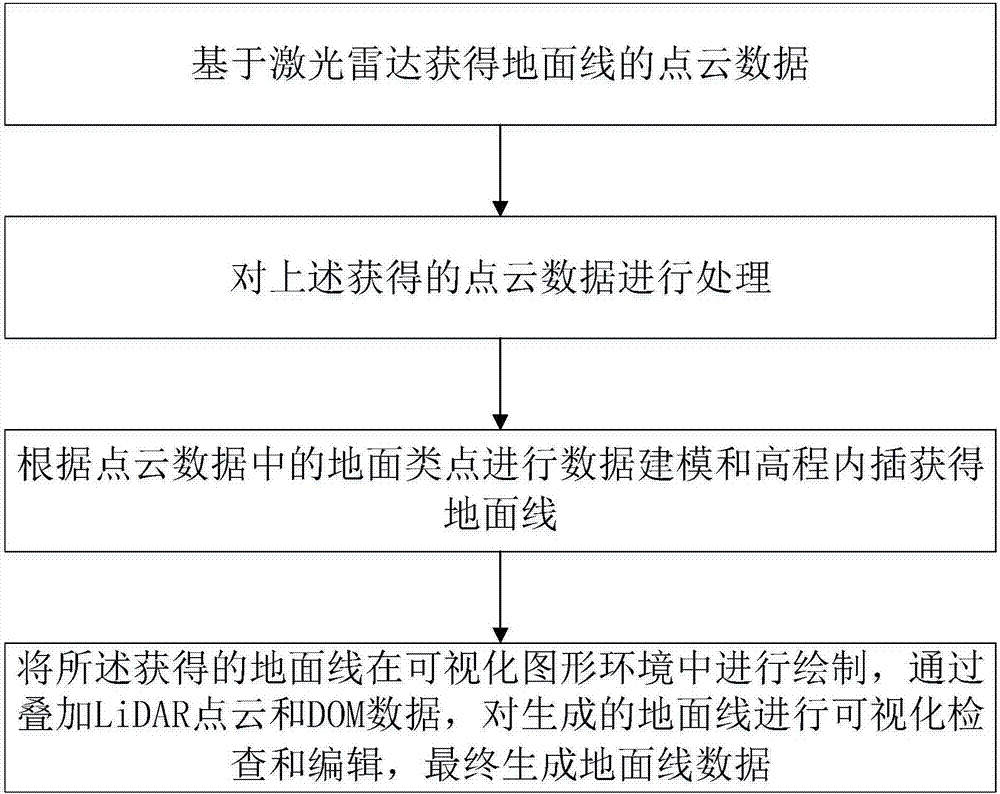
[0037] refer to Figure 1-Figure 2 As shown, the present invention provides a kind of automatic generation system of road surface line data, comprising:

[0038] Laser rad...


PUM


Abstract

The present invention provides a road ground surface line data automatic generation system and method. The system comprises a laser radar, a data processing system and an inspection and editing system; the laser radar is used for obtaining point cloud data of a ground surface line; the data processing system is used for processing the point cloud data and performing data modeling and elevation interpolation based on ground surface type points in the point cloud data to obtain a ground surface line; and the inspection and editing system is used for drawing the obtained ground surface line in a visual graph environment and superposing LiDAR point cloud and DOM data so as to perform visual inspection and editing on the generated ground surface line. With the system of the present invention adopted, rapid automatic extraction of a design ground surface line can be realized; laser radar measurement and road construction map design integration can be realized; and as for a region with many constructions, a ground surface line generated by using system can reflect the real ground surface information of microtopography more accurately compared with a digital-analog interpolation method.

Description

technical field [0001] The invention relates to the field of surveying and mapping, in particular to a system and method for automatically generating highway surface line data. Background technique [0002] At present, the efficiency and accuracy of obtaining ground line information in highway survey and design are low. The current mainstream method is to use total station or real-time differential positioning technology (rael-time kinematic, RTK) to stake out the middle pile first, and then use RTK to measure the elevation of each cross section. However, this method uses single-point contact measurement, which leads to a slow operation speed. At the same time, due to the limitations of natural conditions such as weather, traffic, and difficult terrain in the survey area, it is easy to cause low accuracy of surveying and mapping results, difficult to guarantee the construction period, and survey costs. increased adverse consequences. Contents of the invention [0003] In...

Claims


Application Information

Patent Timeline
IPC IPC(8): G01S17/89
CPCG01S17/89
Inventor 赵延平宋连凯王超朴东国魏立龙
Owner SHANGHAI HUACE NAVIGATION TECH
Why Eureka
Try Eureka