
Map construction and application

A technology of map construction and map information, applied in instruments, navigation, computing, etc., can solve the problem of large amount of map data, achieve the effect of small data collection, cost reduction, and easy real-time update

Inactive Publication Date: 2017-12-08
NIO CO LTD
View PDF10 Cites 55 Cited by
  • Summary
  • Abstract
  • Description
  • Claims
  • Application Information

AI Technical Summary

Problems solved by technology

This method of constructing high-precision maps relies on lidar sensors to collect information, and the amount of collected data and generated map data is very large, which poses challenges to storage and transmission

Method used


Image

  • Map construction and application
  • Map construction and application
  • Map construction and application

Examples


Embodiment Construction

[0077] The present invention will now be described more fully with reference to the accompanying drawings, in which exemplary embodiments of the invention are shown. However, this invention may be embodied in many different forms and should not be construed as limited to the embodiments set forth herein. Rather, these embodiments are provided so that this disclosure will be thorough and complete, and will fully convey the concept of the invention to those skilled in the art.

[0078] Some of the block diagrams shown in the drawings are functional entities and do not necessarily correspond to physically or logically separate entities. These functional entities may be implemented in software, or in one or more hardware modules or integrated circuits, or in different processing means and / or microcontroller means.

[0079] Such as figure 1 with figure 2 As shown, the map construction system of the embodiment of the present invention includes the map construction device 300 of ...


PUM


Abstract

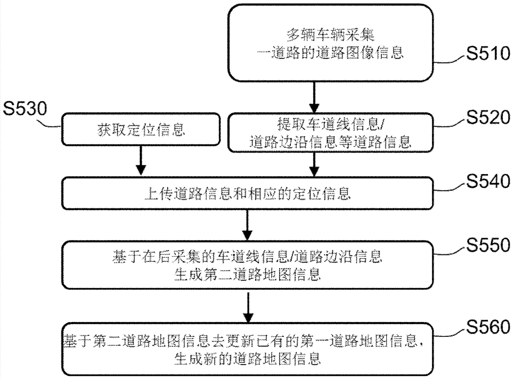
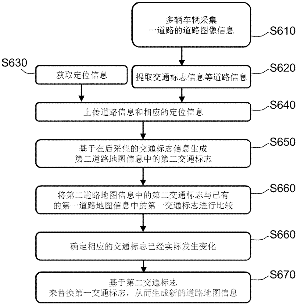
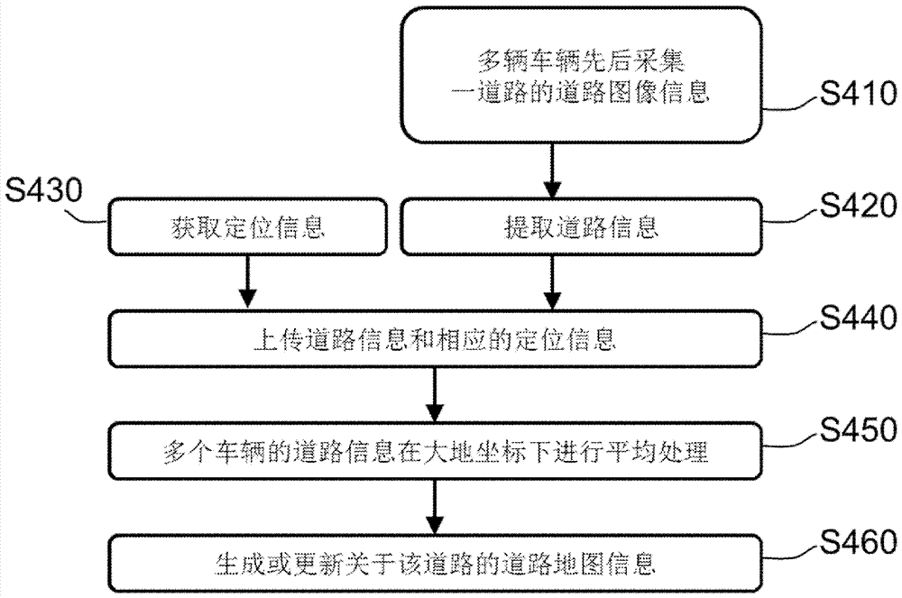
The invention relates to map construction and application, and belongs to the technical field of map construction. The map construction method comprises the steps of successively collecting road image information on a road by multiple vehicles running on the road, and obtaining locating information at a position point where the road image information is collected; extracting road information from the road image information; uploading the road information and the corresponding locating information obtained by the vehicles through the vehicles; and generating or updating road map information on the road based on the road information and the corresponding locating information of the vehicles.

Description

technical field [0001] The invention belongs to the technical field of map construction, and relates to the construction of a high-precision map based on road image information collected by an image sensor and its application. Background technique [0002] High-precision maps are different from traditional road-level maps, which have more detailed information about roads than road-level maps. High-precision maps are the data basis for automatic driving and an important input for automatic driving systems. They are of great significance for improving the performance of automatic driving. which performed. [0003] The accuracy of existing navigation maps is generally not high, and the entire road is used as an object to provide road information data or issue navigation instructions. This kind of navigation map is called a road-level map, which greatly simplifies the actual traffic environment and can provide The amount of information is small and the accuracy is low. [000...

Claims


Application Information

Patent Timeline
Patent Type & Authority Applications(China)
IPC IPC(8): G06K9/00G06K9/32G06K9/46
CPCG06V20/588G06V20/582G06V20/56G06V20/62G06V10/462G01C21/3867G01C21/3815G01C21/3837
Inventor 孙鹏
Owner NIO CO LTD
Learn More