Unmanned aerial vehicle route planning algorithm based on polygonal obstacle detection

An obstacle detection and polygonal technology, applied in vehicle position/route/height control, navigation calculation tools, non-electric variable control, etc., can solve problems such as route depressions

Inactive Publication Date: 2017-12-15
QIANXUN SPATIAL INTELLIGENCE INC
View PDF7 Cites 16 Cited by
  • Summary
  • Abstract
  • Description
  • Claims
  • Application Information

AI Technical Summary

Problems solved by technology

In the current UAV map test that contains various polygonal obstacle areas, it can gener

Method used


Image

  • Unmanned aerial vehicle route planning algorithm based on polygonal obstacle detection
  • Unmanned aerial vehicle route planning algorithm based on polygonal obstacle detection
  • Unmanned aerial vehicle route planning algorithm based on polygonal obstacle detection

Examples


Embodiment Construction

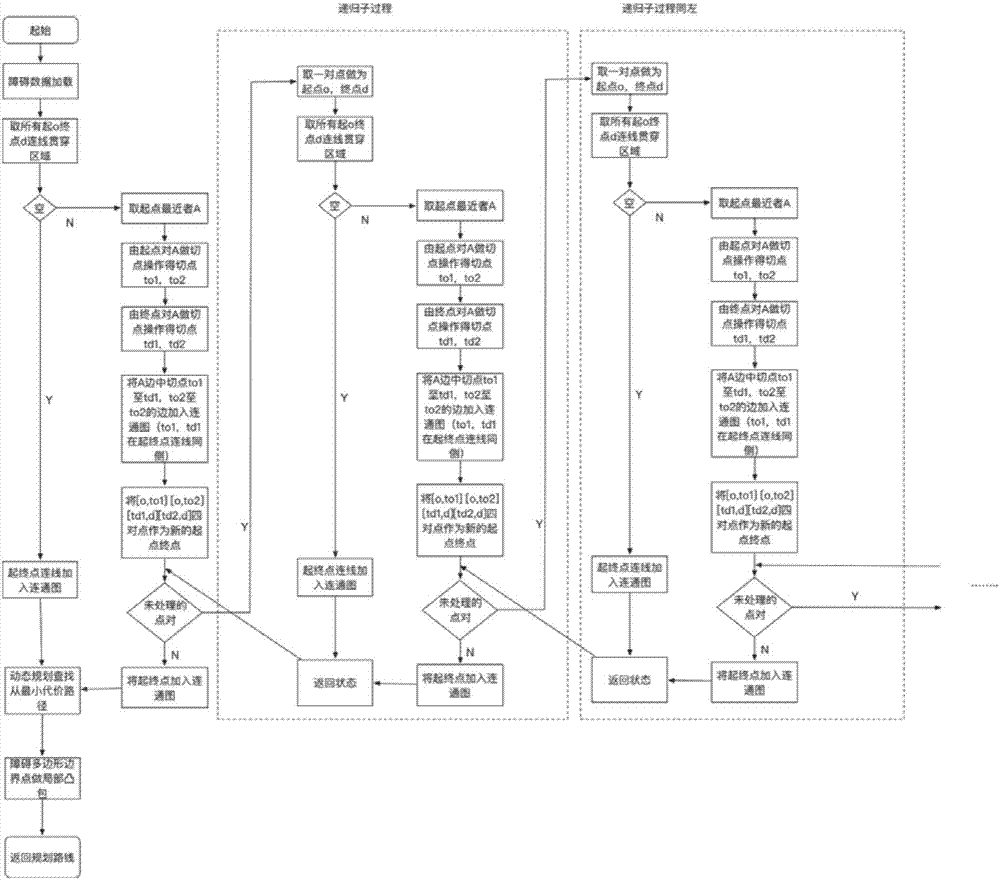
[0035] The invention provides a UAV route planning algorithm based on obstacle detection: 1) For the obstacle area closest to the starting point on the connection line between the starting point and the ending point, use the starting point and ending point to perform a point-cutting operation on it; The point is used as the new starting point and the ending point, and the tangent point from the ending point to the ending point is used as the new starting point and ending point, which is the main process of the algorithm for recursive planning. 2) Perform a point-cutting operation on the polygonal obstacle area from the point. 3) The local convex hull optimization operation of polygons based on virtual auxiliary points.

[0036] Hereinafter, the present invention will be further described in conjunction with the drawings and embodiments.

[0037] 1) The main process of UAV route planning algorithm

[0038] figure 1 It is a flow chart of the main process of the UAV route plan...


PUM


Abstract

The invention provides an unmanned aerial vehicle route planning algorithm based on polygonal obstacle detection. The unmanned aerial vehicle route planning algorithm mainly comprises two steps of connected graph establishment and route generation. The algorithm is based on the operation taking a point as a tangent point relative to an original polygon of an obstacle, recursion obstacle detection is performed from an original point to the tangent point, so that an initial detouring route is obtained, and convex hull operation is performed on part of the polygon to optimize a route result. An accurate global optimal route is produced. In the current unmanned aerial vehicle map testing containing carious polygonal obstacle regions, an accurate global optimal route can be produced, and a problem of route depression is solved. The algorithm is not limited to unmanned aerial vehicle route planning. Tangent point operation corresponding to specific shapes can further be arbitrarily selected according to scenes.

Description

technical field [0001] The invention relates to the technical field of UAV route planning, in particular to an UAV route planning algorithm based on polygonal obstacle detection. Background technique [0002] With the development of drone technology and market popularization, drones have also been widely used in civil fields such as aerial photography, inspection, agriculture, forestry and plant protection, environmental protection, and post-disaster rescue. However, in reality, there are many complicated restrictions on the flight routes of drones, such as buildings, airports, government agencies, schools, crowded areas and other no-fly zones. It will cause personal safety risks and even directly cause accidents. Therefore, planning a safe and globally optimal route that avoids all sensitive areas before UAV operation has become an urgent need. [0003] There are many constraints in the route planning of UAV flight. In addition to the kinematics and mobility limitations ...

Claims


Application Information

Patent Timeline
IPC IPC(8): G01C21/20G05D1/10
CPCG01C21/20G05D1/101
Inventor 窦金生
Owner QIANXUN SPATIAL INTELLIGENCE INC
Why Eureka
Try Eureka