Land change investigation information management system of three-checking unification

An information management system and information management technology, applied in the field of land change survey information management system, can solve the problems of long cycle, heavy workload, cumbersome process, etc., and achieve the effects of saving manpower and material resources, high work confidentiality, and high work efficiency.

Inactive Publication Date: 2017-12-26
青岛市房地产信息与交易资金监管中心 +1
View PDF3 Cites 40 Cited by
  • Summary
  • Abstract
  • Description
  • Claims
  • Application Information

AI Technical Summary

Problems solved by technology

These methods have certain defects and deficiencies: remote sensing means can only achieve macroscopic monitoring, and cannot obtain information on land use changes from local to plots; there is a lack of field survey data and efficient survey methods. The traditional aerial survey and mapping method is still used, which is inefficient; the data results of the field survey are basically paper-based data, which cannot be directly entered into the GIS database, requiring complicated internal processing; the traditional field survey method is inefficient and the workload Large, long period, unable to obtain short-term land use changes in time
For the superior review of the map and the processing of the returned map, the traditional mode is still continued, and the process is relatively cumbersome
[0004] It can be seen that the existing land change survey methods cannot fully meet the actual needs of users, and more accurate, fast and systematic solutions are needed

Method used


Image

  • Land change investigation information management system of three-checking unification
  • Land change investigation information management system of three-checking unification
  • Land change investigation information management system of three-checking unification

Examples


Embodiment Construction

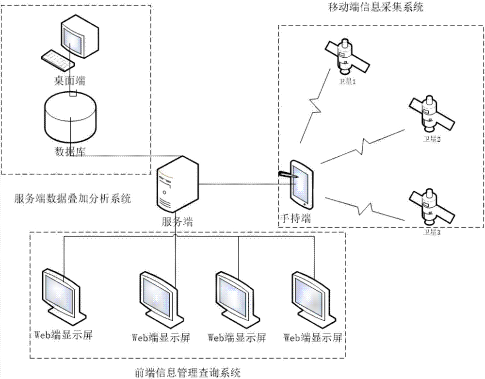
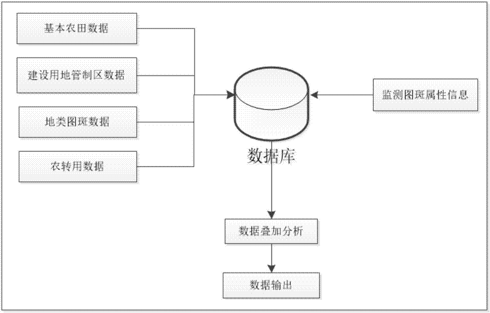
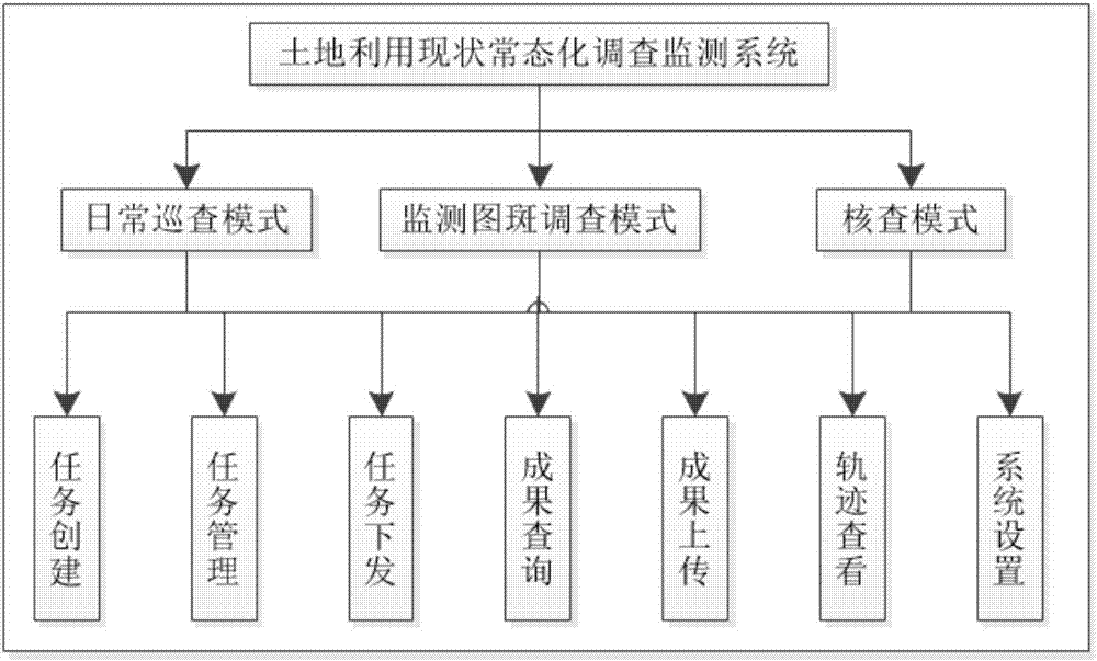
[0025] The invention provides a three-inquiry-in-one land change investigation information management system, specifically a land use status normalization investigation and monitoring system based on the Internet and a geographic information system. The present invention integrates the three common modules of inspection, monitoring pattern investigation and verification in land use status investigation, and four users including city-level users, district and city-level users, town-level users and investigators are identified through self-defined user naming rules. Connect with high-level users to realize the paperless integration function of the normalized investigation of land use status from distribution to investigation to upload to management review. The invention solves the problems of cumbersome and heavy workload in the current normalized investigation process of land use status. Users at all levels perform their own duties, and the superior can play the role of supervi...


PUM


Abstract

The invention discloses a land change investigation information management system of three-checking unification. The system comprises a server-side data superposition analysis system, a front-end information management query system and a mobile terminal information acquisition system. The server-side data superposition analysis system processes and analyzes pattern spot information and a land base database, and carries out storage and shares to a server through the front-end information management query system. The mobile terminal information acquisition system downloads data in an on-line mode, carries out real-time positioning and field-operation non-paper information acquisition, and returns to the server. The front-end information management query system is used to realize management and query, uploading and audit, and analysis and statistics of pattern spot data. In the invention, a pattern spot flow function of departments at all levels, in which patrol, investigation and checking are integrated into one body, is realized; a traditional flow is optimized and recombined; whole-course on-line operation of pattern spots is realized; and operating efficiency of investigation work is increased and a great safety meaning of the data is guaranteed.

Description

technical field [0001] The invention relates to a three-in-one land change investigation information management system, which belongs to the field of land change investigation management. Background technique [0002] Land is a non-renewable resource that human beings rely on for survival and development, and land resources are an important part of national land resources. With the rapid development of our country's economy, the status quo of land use has also undergone great changes. Timely and accurate acquisition of land use change information and regular update of the basic database of land use directly affect the government's decision-making and the management of land departments. The State Council issued relevant notices for the purpose of comprehensively investigating land use conditions, mastering real basic land data, establishing and improving land survey, statistics and registration systems, realizing socialized services for land survey information, and meeting th...

Claims


Application Information

Patent Timeline
Patent Type & Authority Applications(China)
IPC IPC(8): G06Q50/16G06F17/30
CPCG06F16/29G06Q50/165
Inventor 季民张春生徐学涛张欣杰靳奉祥李婷孙勇贾宁孙李城宁方志陈许霞金泽华刘佳周丽莎杨国超张国强付雁刘金霞陈柳阳李建伟贺天张弯
Owner 青岛市房地产信息与交易资金监管中心
Why Eureka
Try Eureka