
Building modeling method under the constraint of spatial topology relationship based on lidar point cloud

A technology of spatial topology and modeling method, applied in the field of building modeling, can solve the problems of building model building, easy to cause fragmentation, affecting the accuracy of building reconstruction results, etc., and achieve the effect of accurate reconstruction and good reconstruction effect.

Active Publication Date: 2021-04-27
长江空间信息技术工程有限公司(武汉)
View PDF6 Cites 1 Cited by
  • Summary
  • Abstract
  • Description
  • Claims
  • Application Information

AI Technical Summary

Problems solved by technology

[0004] At present, there are two main methods for building model configuration: one is to use the step edge and roof line features extracted from the LiDAR building point cloud as the basis for space division, and reconstruct the building boundary based on the BSP algorithm. Reconstruct the building model; the second is to reconstruct the building model based on the "Split-Merge-Shape" algorithm, where the two steps of split-merge are mainly to reconstruct the topological relationship between the building structure lines, Complete the closed polygon; the two methods have certain similarities in principle, the core lies in the space division process, the correctness of the space division results directly determines the effect of the final model reconstruction; however, because the spatial topology between the patches is not restored in advance There is a certain blindness in space division, which is easy to cause broken small spaces, thus affecting the accuracy of the final building reconstruction results
[0005] The application number is 201110218035.9, and the patent name is "A Method for Quickly Extracting 3D Outline Information of Buildings from Airborne LiDAR Data", which proposes a method for quickly extracting 3D outline information of buildings in airborne LiDAR data. The patent titled "Method for Extracting Building Outlines from Lidar Point Cloud Data Based on Curvature" proposed a method for extracting building outlines from Lidar point cloud data based on curvature, but did not further give how to extract building outlines based on the extracted A Method of Constructing Building Model Based on Contour Information

Method used


Image

  • Building modeling method under the constraint of spatial topology relationship based on lidar point cloud
  • Building modeling method under the constraint of spatial topology relationship based on lidar point cloud
  • Building modeling method under the constraint of spatial topology relationship based on lidar point cloud

Examples


Embodiment

[0085] The modeling method of a certain building in a certain place based on the spatial topological relationship constraints of the LiDAR point cloud is taken as an example to illustrate, and it also has a guiding role for other building modeling methods based on the spatial topological relationship constraints of the LiDAR point cloud.

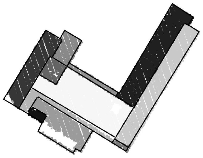
[0086] Step 1: Carry out point cloud segmentation processing and building contour extraction on the LiDAR point cloud of the building in the target area, and obtain the precise two-dimensional outer contour and elevation information of the building as well as the geometric primitives of the building roof (such as figure 2 shown);

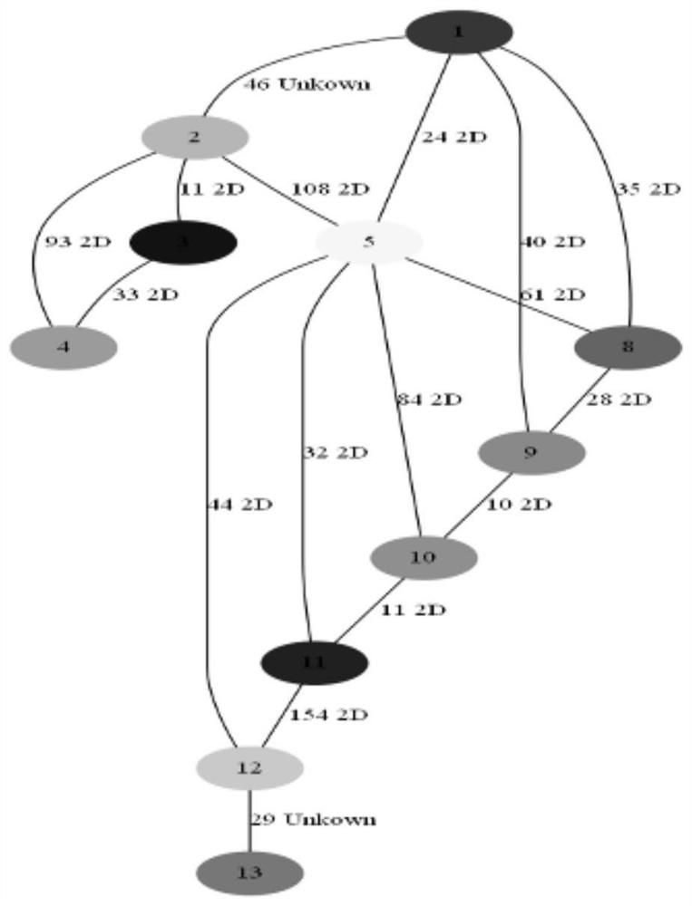
[0087] Step 2: For the building roof geometric primitives, extract adjacent point pairs between the adjacent building roof geometric primitives; calculate and analyze the spatial connection relationship between adjacent point pairs, and determine the relationship between the building roof geometric primitives The...


PUM


Abstract

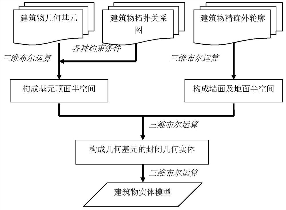
The invention discloses a building modeling method under the constraint of the spatial topological relation based on LiDAR point cloud. It includes the following steps: performing point cloud segmentation processing and building contour extraction on the LiDAR point cloud of the building in the target area, obtaining the precise two-dimensional outer contour of the building and the mathematical expression of the geometric primitives of the building roof; constructing the building The spatial topological relationship diagram of the geometric primitives of the roof of the building; the three-dimensional Boolean operation rules between the geometric primitives of the building roof are defined; after the three-dimensional Boolean operation is performed on the geometric primitive polyhedron of the roof of each building, the top half space of the primitive is obtained, according to Accurate two-dimensional outer contour and elevation information of the building to obtain the wall and ground half-space completely including the building entity model, and perform three-dimensional Boolean operations on the top half-space of the primitive and the half-space of the wall and the ground Intersection operation is performed to obtain the solid model of the building. It has the advantage of reducing the spatial fragmentation of the building model.

Description

technical field [0001] The invention relates to the technical field of airborne laser radar, more specifically, it is a building modeling method under the constraints of spatial topological relationship based on LiDAR point cloud. Background technique [0002] LiDAR (Light Detection And Ranging) is laser detection and measurement, which uses GPS (Global Position System) and IMU (Inertial Measurement Unit, inertial measurement unit) airborne laser scanning; the measured data is the Digital Surface Model (Digital Surface Model) , DSM) discrete point representation, the data contains spatial three-dimensional information and laser intensity information. Apply classification (Classification) technology to remove buildings, artificial objects, covering plants and other measuring points in these original digital surface models, and then obtain a digital elevation model (Digital ElevationModel, DEM), and at the same time obtain the height of the ground cover. [0003] The existing...

Claims


Application Information

Patent Timeline
Patent Type & Authority Patents(China)
IPC IPC(8): G06T17/10G06T7/13G06T7/12
Inventor 李云帆钟良喻静敏甘拯汤璇
Owner 长江空间信息技术工程有限公司(武汉)
Learn More