Surveying instrument based on land survey

A land surveying and mapping instrument technology, applied in the field of surveying and mapping instruments, can solve the problems of no support, time-consuming, limited size of the cloud platform, etc., to achieve the effect of reducing fatigue, avoiding sore hands, and preventing elbows

Inactive Publication Date: 2018-02-02
成都行泽科技有限公司
View PDF0 Cites 3 Cited by
  • Summary
  • Abstract
  • Description
  • Claims
  • Application Information

AI Technical Summary

Problems solved by technology

[0004] The technical problem to be solved by the present invention is that the surveying and mapping instruments are generally placed on the surveying and mapping instrument support for measurement; the traditional surveying and mapping instrument support is generally a tripod support, which requires manual lifting when moving, which is very time-consuming and labor-intensive. , the tripod bracket is generally a fixed pan platform, but the size of the fixed pan platform is limited

Method used


Image

  • Surveying instrument based on land survey
  • Surveying instrument based on land survey

Examples


Embodiment

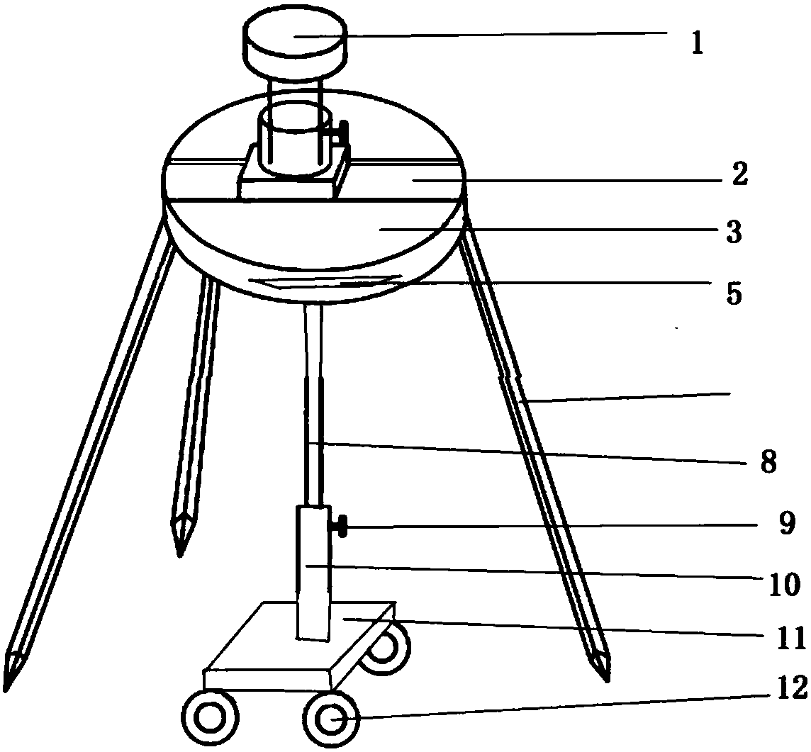
[0021] Such as Figure 1-2 As shown, the surveying instrument that the present invention uses based on land survey includes a cloud platform chassis 3, and three support feet 5 are arranged below the cloud platform chassis 3, and the support feet 5 are connected with the cloud platform chassis 3 rotating shafts, and the cloud platform chassis 3. There is also a sliding rod 8 below. The sliding rod 8 is connected to the upper surface of the mobile plate 11 through the sleeve 10. The lower surface of the mobile plate 11 is provided with pulleys 12. The number of the pulleys 12 is 4, and they are evenly arranged in a 2*2 array. The outer wall of the sleeve 10 is connected to the infrared detector 9, and the infrared detector 9 detects the road surface information in front of the sleeve 10 and sends it to the controller. The controller is arranged inside the moving plate 11, and the controller receives the infrared detector 9 The information controls the rotation of the motor shaf...


PUM


Abstract

The invention discloses that a surveying instrument used based on land surveying includes a pan-tilt chassis, and three support feet are arranged under the pan-tilt chassis, and the support feet are connected with the rotation shaft of the pan-tilt chassis, and a sliding rod is also arranged under the pan-tilt chassis, so that The sliding rod is connected to the upper surface of the mobile plate through a sleeve, and pulleys are arranged on the lower surface of the moving plate, and the number of the pulleys is 4, which are evenly arranged in a 2*2 array; the outer wall of the sleeve is connected to an infrared detector, and the infrared detector The sensor detects the road surface information in front of the sleeve and sends it to the controller. The controller is set inside the moving plate, and the controller receives the information from the infrared detector to control the rotation of the motor shaft; the motor shaft is set at the connection between the moving plate and the sleeve. . A sliding groove is set above the chassis of the cloud platform, and a sliding platform that can extend the sliding groove is arranged on the sliding groove, and the platform lifting plate is arranged on the top of the sliding platform through a lifting device, and the lifting device includes an adjustment handle; The chassis is provided with an interlayer with openings at both ends.

Description

technical field [0001] The invention relates to a tripod device, in particular to a surveying instrument used based on land surveying. Background technique [0002] Surveying and mapping instruments, simply speaking, are instruments and devices designed and manufactured for surveying and mapping operations such as data acquisition, processing, and output, and various orientation, ranging, and Angle, height measurement, mapping and photogrammetry, etc. The surveying instrument can also combine light, machinery and electricity to take the workpiece into the computer for processing and magnify it by 18 to 230 times, and display it on the screen. You can directly take pictures for archiving or do Surface observation, measurement, and drawing. The measurement data can be used for SPC statistics and made into EXCEL reports. The drawing files can be converted into AUTOCAD applications, and the AUTOCAD graphics can also be transferred to computer software for comparison with workpie...

Claims


Application Information

Patent Timeline
IPC IPC(8): G01C15/00
CPCG01C15/00
Inventor 罗世乐谭晓晶
Owner 成都行泽科技有限公司
Why Eureka
Try Eureka