
GIS-based hydrologic station data management system

A data management system and hydrological station technology, applied in the field of GIS-based hydrological station data management system, can solve the problems of inability to retrieve data, correlate analysis, and inability to perform comparative analysis of hydrological station data, and achieve maintenance security and ease of use. Effect

Inactive Publication Date: 2018-02-16
张永平 +2
View PDF3 Cites 2 Cited by
  • Summary
  • Abstract
  • Description
  • Claims
  • Application Information

AI Technical Summary

Problems solved by technology

[0005] 1. The data management method of the hydrological station is relatively simple
Using database or table management, the data of some hydrological stations has not yet been managed by computer system, and exists in the form of files. The consequence of this management method is that fast data retrieval cannot be performed, and even data loss
These data have valuable scientific research value. When using table retrieval, it is impossible to form a more effective data value analysis, and it cannot be related to the surrounding environment, actual geographical location, and regional association. Since the founding of the People’s Republic of China, geographical environment, administrative division, rivers and lakes There are many changes, and the data of hydrological stations in different years cannot be compared and analyzed. Manual processing is required before comparison, and the efficiency of manual processing is low
[0006] 2. Hydrological station data is not associated with other dimension data
When hydrological station data is maintained, it does not include other data, which leads to manual intervention when hydrological data is associated with population data or economic data, and several data are manually merged together for data collision analysis, and automatic analysis cannot be realized , or data collision analysis based on administrative regions and locations

Method used


Image

  • GIS-based hydrologic station data management system

Examples


Embodiment 1

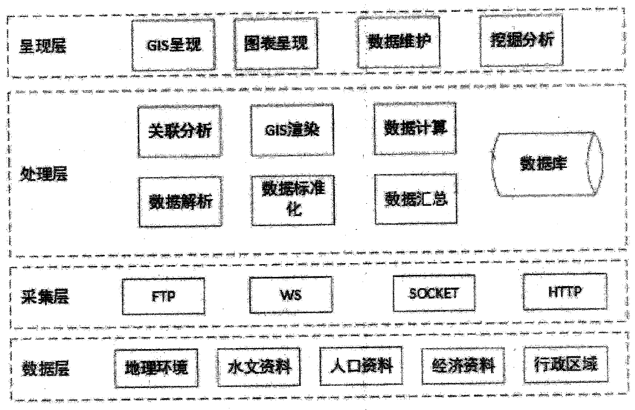
[0022] see figure 1 , in an embodiment of the present invention, a GIS-based hydrological station data management system is composed of a data layer, an acquisition layer, a processing layer, and a presentation layer. The data layer is the original data collected and used by the system. This system is a platform architecture. The acquisition layer has a variety of protocol adapters and has scalable functions. The new acquisition protocol can be directly expanded. The processing layer is the core of the management system, which undertakes the actual business processing, cleaning, integrating, correlating, calculating and summarizing the data. Obtain the hydrological station data that can be presented. After the processing is completed, the presentation layer can present the analysis and calculation results through the WEB interface, and some data can be used by system users for maintenance.

[0023] 1. Data layer:

[0024] The data layer represents the type of data accessed by...


PUM


Abstract

The invention discloses a GIS-based hydrologic station data management system. The system is composed of a data layer, a collection layer, a processing layer and a display layer, wherein the data layer is collected and used data of different data types; according to the collection layer, all the data in the data layer is collected through a protocol adapter; the processing layer is the core of themanagement system and undertakes actual service processing to clean, integrate, correlate, calculate and summarize all the data; and the display layer displays an analysis calculation result througha WEB interface. The processing layer comprises a data analysis module, a data standardization module, a data summarization module, a correlation analysis module, a GIS rendering module, a data calculation module and a database. The system can be persistently saved through a GIS and a chart, maintenance and query are performed through the GIS and the chart, a correlation collision analysis function of hydrologic station data and other industrial data is provided, the security and usability of the hydrologic station data are maintained, and a value analysis method for the hydrologic station data is provided.

Description

technical field [0001] The invention relates to the technical field of computer systems, in particular to a GIS-based hydrological station data management system. Background technique [0002] Hydrological stations are grassroots hydrological institutions that observe and collect hydrological and meteorological data of rivers, lakes, reservoirs and other water bodies. The hydrological elements observed by the hydrological station include water level, flow velocity, flow direction, wave, sand concentration, water temperature, ice regime, groundwater, water quality, etc.; meteorological elements include precipitation, evaporation, air temperature, humidity, air pressure, and wind. After these data are collected from hydrological stations, they are processed, standardized and printed to form a water conservancy yearbook or stored in a computer system. [0003] When using these data, there are two ways of reading the water conservancy yearbook or querying the computer system. ...

Claims


Application Information

Patent Timeline
Patent Type & Authority Applications(China)
IPC IPC(8): G06Q10/10
CPCG06Q10/103
Inventor 张永平张涛刘德东刘璐彭慧
Owner 张永平
Learn More