Ionosphere scintillation satellite signal simulation system and usage method thereof

A technology of satellite signal and simulation system, which is applied in the field of satellite signal simulation system, and can solve problems such as the environment where the ionospheric scintillation of BDS/GPS satellite signals cannot be reproduced

Active Publication Date: 2018-02-23
GUILIN UNIV OF ELECTRONIC TECH
View PDF7 Cites 9 Cited by
  • Summary
  • Abstract
  • Description
  • Claims
  • Application Information

AI Technical Summary

Problems solved by technology

[0004] The technical problem to be solved by the present invention is the technical problem existing in the prior art that cannot reproduce the ionospheric scintillation environment experienced in the BDS / GPS satellite signal propagation process

Method used


Image

  • Ionosphere scintillation satellite signal simulation system and usage method thereof
  • Ionosphere scintillation satellite signal simulation system and usage method thereof
  • Ionosphere scintillation satellite signal simulation system and usage method thereof

Examples


Embodiment 1

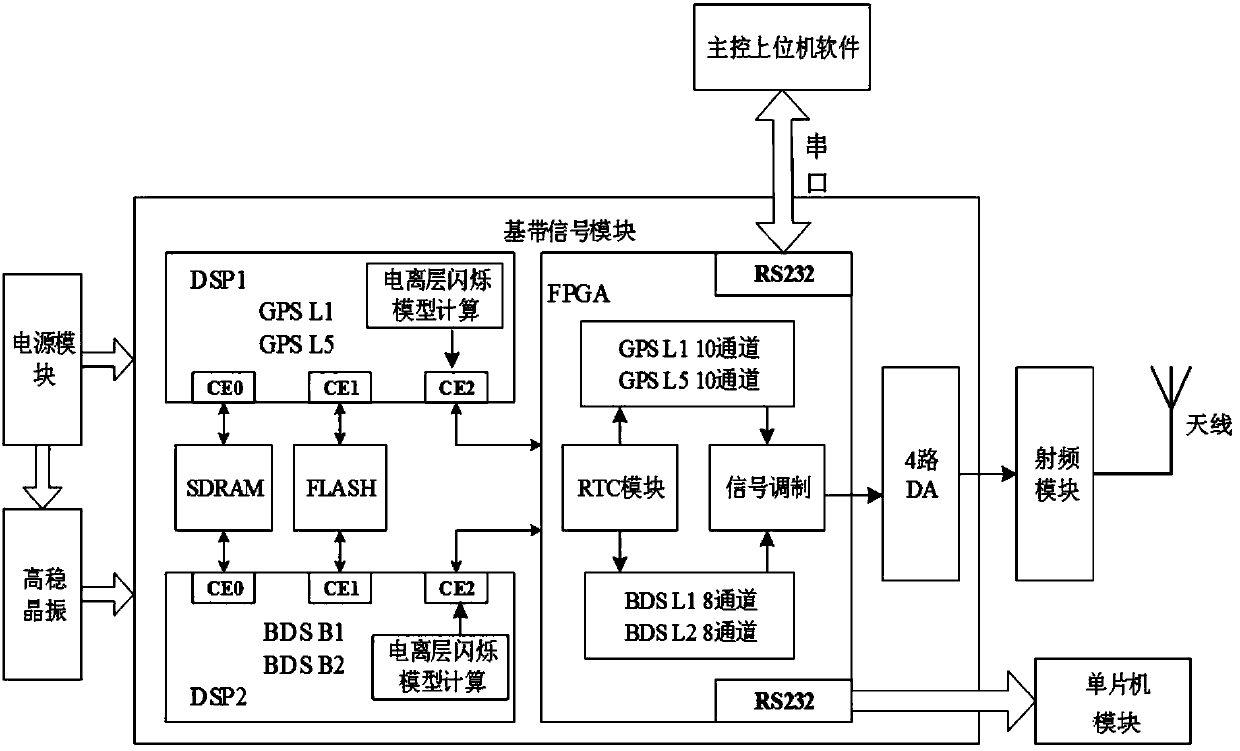
[0074] This embodiment provides a satellite signal simulation system for ionospheric scintillation, which is suitable for BDS / GPD satellite signals, such as figure 1 , including a hardware device connected through a serial port and an upper computer, the upper computer is configured with upper computer software, and the upper computer software is used to generate scene files required by the hardware device, configure simulation parameters and control the display hardware device; the hardware device includes a baseband Signal module, high stable crystal oscillator connected with baseband signal module, single-chip microcomputer module, DA module and power module, DA module is also connected with radio frequency module and antenna in turn, and the working frequency band of antenna covers BDS / GPS satellite signal frequency; The described single-chip microcomputer module is used It is used to process the simulator parameters sent by the baseband signal module through the serial por...


PUM


Abstract

The invention relates to an ionosphere scintillation satellite signal simulation system and a usage method thereof, is suitable for BDS/GPS satellite signals, and aims to solve the ionosphere scintillation environment technical problems in the BDS/GPS satellite signal propagation process; the satellite signal simulation system is suitable for the BDS/GPS satellite signals, and comprises a hardwaredevice and a host computer connected through a series port; the host computer is configured with host computer software; the host computer software is used for forming a hardware device needed scenefile and configuration simulation parameters, and controlling and displaying the hardware device; the hardware device comprises a baseband signal module, a high stability crystal oscillator connectedwith the baseband signal module, a single-chip microcomputer module, a DA module and a power supply module; the DA module is also connected in order with a radio frequency module and an antenna; the antenna work frequency range covers the BDS/GPS satellite signal frequencies. The ionosphere scintillation satellite signal simulation system can well solve said problems, and can be applied to the satellite navigation positioning field.

Description

technical field [0001] The invention relates to the field of navigation and positioning, in particular to an ionospheric scintillation satellite signal simulation system and a using method. Background technique [0002] With the continuous development and maturity of satellite navigation technology, the wide application of satellite navigation system has played a huge role in promoting national economic and social development, and in recent years, in precision agriculture, scientific research (field biology, meteorology, earth Science), environmental monitoring, emergency and disaster assessment, safety assurance, celestial and architectural engineering, and natural resource analysis have been increasingly used. At present, the mainstream satellite navigation systems in the world include GPS of the United States, GLONASS of Russia, Beidou of China and Galileo of Europe. GPS is the world's first mature satellite navigation system, which has omnipotent, global, all-weather co...

Claims


Application Information

Patent Timeline
Patent Type & Authority Applications(China)
IPC IPC(8): G01S7/40
CPCG01S7/4052G01S7/4082
Inventor 孙希延付文涛纪元法符强王守华严素清邓洪高吴孙勇欧阳缮
Owner GUILIN UNIV OF ELECTRONIC TECH
Why Eureka
Try Eureka