
A vehicle-mounted positioning and directional aiming system and aiming method integrating inertial and satellite

A satellite positioning, positioning and orientation technology, which is applied in satellite radio beacon positioning systems, radio wave measurement systems, instruments, etc., can solve the problems of poor positioning accuracy and reliability, and achieve strong environmental adaptability, fast positioning and orientation speed, high precision effect

Active Publication Date: 2020-08-07
BEIJING INST OF SPACE LAUNCH TECH +1
View PDF5 Cites 0 Cited by
  • Summary
  • Abstract
  • Description
  • Claims
  • Application Information

AI Technical Summary

Problems solved by technology

[0005] In order to solve the technical problems of poor reliability and poor positioning accuracy in the existing positioning, directional and aiming methods, the present invention innovatively proposes a vehicle-mounted positioning, directional and aiming system and targeting method that integrates inertia and satellites, combining the inertial vehicle positioning, directional and aiming scheme and Satellite vehicle positioning, orientation and aiming are effectively combined, and the inertial positioning and orientation data are reasonably fused with satellite positioning and orientation data to realize the complementary advantages of the two, and provide a redundant solution in case of accidents, ensuring that the positioning and orientation data are continuous, reliable, High-precision output completely solves technical problems such as poor reliability and poor positioning accuracy existing in the existing positioning, directional and aiming methods

Method used


Image

  • A vehicle-mounted positioning and directional aiming system and aiming method integrating inertial and satellite
  • A vehicle-mounted positioning and directional aiming system and aiming method integrating inertial and satellite
  • A vehicle-mounted positioning and directional aiming system and aiming method integrating inertial and satellite

Examples


Embodiment 1

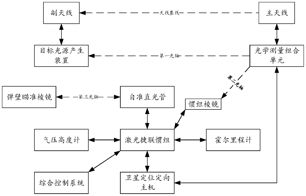
[0050] Such as Figures 1 to 3 As shown, the present invention discloses a vehicle-mounted positioning and orientation targeting system that integrates inertia and satellites. The system mainly includes inertial positioning and orientation equipment and satellite positioning and orientation equipment. The inertial positioning and orientation equipment mainly includes laser strapdown inertial groups, autocollimation light Tube, barometric altimeter, Hall odometer, dead reckoning unit, extended Kalman filter, standard Kalman filter, joint Kalman filter and cable network for signal transmission, satellite positioning and orientation equipment mainly includes main antenna, Auxiliary antenna, satellite positioning and orientation host, optical measurement combination unit and target light source generation device; among them, the optical measurement combination unit and target light source generation device together form an optical reference transmission subsystem, which completes t...

Embodiment 2

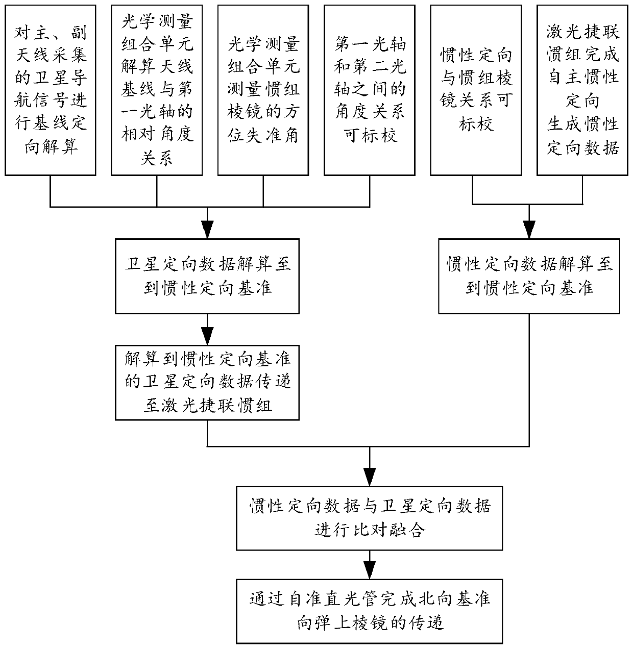
[0067] This embodiment is based on the same inventive concept as Embodiment 1, such as Figure 1-3 As shown, this embodiment specifically discloses a method for merging inertial and satellite-based vehicle positioning and targeting, or in other words, this embodiment actually discloses a method for aiming using fused inertial and satellite-based vehicle positioning and directional targeting. The method includes the following steps.

[0068] In the inertial orientation data acquisition step, the autonomous inertial orientation is completed through the laser strapdown inertial group, and the inertial orientation data is generated; in this embodiment, this step also includes the step of temperature compensation for the inertial devices in the laser strapdown inertial group. In this embodiment, temperature-related error compensation is performed on the laser gyroscope and accelerometer, and the continuous compensation model can be used to improve the compensation accuracy, so as t...


PUM


Abstract

The present invention discloses a system and a method for vehicle positioning and orientation aiming with fusion of inertia and a satellite. The system comprises a laser strapdown inertial measurementunit, an auto-collimation optical tube, an atmospheric pressure altimeter, a Hall odometer, a dead reckoning unit, an extended Kalman filter, a standard Kalman filter, a federated Kalman filter, a main antenna, a secondary antenna, a satellite positioning and orientation host, an optical measurement combination unit and a target light source generation device. The method comprises the steps of: an inertial orientation data obtaining step, a satellite orientation data obtaining step, an orientation data comparison and fusion step, an inertial positioning data obtaining step, a satellite positioning data obtaining step, a positioning data fusion step, and an orientation and positioning data transmission step. The system and the method for vehicle positioning and orientation aiming with fusion of the inertia and the satellite can achieve positioning and orientation functions with high precision, and can achieve that an orientation result is transmitted to a missile launch control system;and moreover, the system and the method are high in precision, fast in positioning and orientation speed and high in adaptive capacity to an environment, and can satisfy demands of the missile launchcontrol system to offhand rapid emission.

Description

technical field [0001] The present invention relates to the technical field of vehicle-mounted positioning, directional and aiming, more specifically, the present invention relates to a vehicle-mounted positioning, directional and aiming system and a targeting method that integrate inertia and satellites. Background technique [0002] At present, in order to realize the positioning, directional and aiming function of the launch vehicle, the inertial positioning and directional aiming method and the satellite positioning and directional aiming method are two commonly used means. However, both the existing inertial positioning directional aiming method and the satellite positioning directional aiming method have their own insurmountable defects. [0003] With long-term use, the gyroscope used in the inertial positioning and directional aiming method will produce random drift, and the positioning and orientation errors will accumulate over time. If the inertial device is not ca...

Claims


Application Information

Patent Timeline
Patent Type & Authority Patents(China)
IPC IPC(8): G01S19/45G01S19/47G01C21/16
CPCG01C21/165G01S19/45G01S19/47
Inventor 狄世超王盛王缜李海洲陈为段祉鸿邓志宝卫瑞陈鸿跃陈雨
Owner BEIJING INST OF SPACE LAUNCH TECH
Learn More