
Strap-down inertial navigation system/visual odometer integrated navigation method

A strapdown inertial navigation and visual odometer technology, applied in the field of integrated navigation, can solve problems such as impact and noise sensitivity, and achieve the effects of improving accuracy, reducing impact, improving positioning accuracy and robustness

Pending Publication Date: 2018-03-13
HARBIN ENG UNIV
View PDF4 Cites 32 Cited by
  • Summary
  • Abstract
  • Description
  • Claims
  • Application Information

AI Technical Summary

Problems solved by technology

However, FAST only processes a small number of pixels, so it is particularly sensitive to noise and is easily affected by the surrounding environment.

Method used


Image

  • Strap-down inertial navigation system/visual odometer integrated navigation method
  • Strap-down inertial navigation system/visual odometer integrated navigation method
  • Strap-down inertial navigation system/visual odometer integrated navigation method

Examples


Embodiment Construction

[0027] The present invention will be described in detail below in conjunction with specific implementation examples.

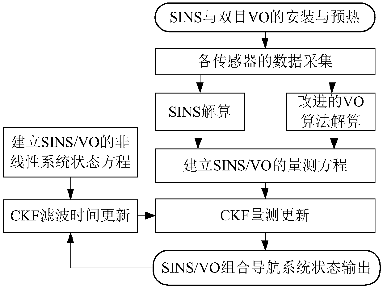
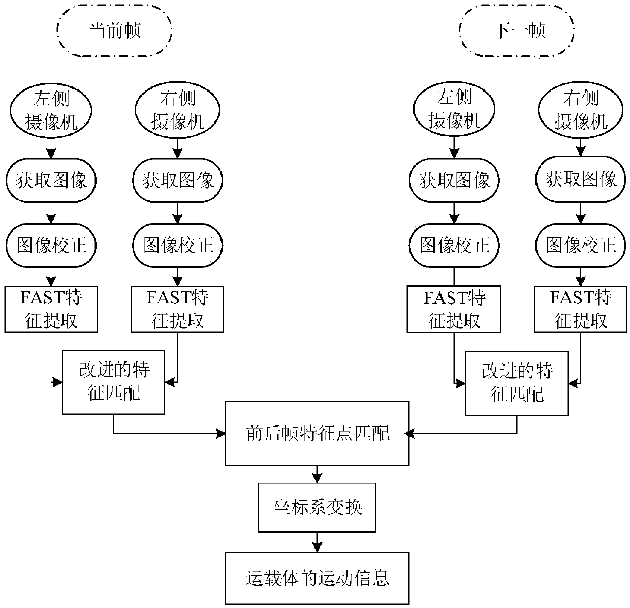
[0028] The present invention is an improved strapdown inertial navigation system / visual odometer combined navigation method based on random sampling consistency, combining Figure 1~2 Shown algorithm flow chart, its specific implementation mode is:

[0029] Step 1: Install binocular visual odometer, fiber optic gyro inertial navigation system and global positioning system on the vehicle, wherein the strapdown inertial navigation system and global positioning system work in the integrated navigation mode and serve as data reference. Preheat the sensors and equipment on the carrier, and collect the data of each sensor and equipment;

[0030] Step 2: Use the binocular camera in the visual odometer to collect the image sequence of the surrounding environment of the vehicle, and complete the correction of the image sequence; use the FAST method to perform segmenta...


PUM


Abstract

The invention provides a strap-down inertial navigation system / visual odometer integrated navigation method which comprises the following steps: mounting a binocular visual odometer and a fiber-opticgyroscope inertial navigation system on a transporter and collecting data of all sensors; extracting features in an image sequence with an FAST method, completing feature matching with a feature matching method based on random sample consensus and calculating movement information of the transporter; establishing a nonlinear state equation and a measurement equation of a strap-down inertial navigation system / visual odometer integrated navigation system; and completing time update and measurement update of the strap-down inertial navigation system / visual odometer integrated navigation system with a volume Kalman filter of a nonlinear filter, and estimating the state of the system, so as to realize the navigation and location of the strap-down inertial navigation system / visual odometer integrated navigation system. According to the strap-down inertial navigation system / visual odometer integrated navigation method, a feature matching algorithm is optimized, and a nonlinear volume Kalman filter algorithm is utilized, so that the location accuracy and the robustness of the integrated navigation system are improved.

Description

technical field [0001] The invention belongs to the field of combined navigation, in particular to a strapdown inertial navigation system / visual odometer combined navigation method. Background technique [0002] In recent years, the independent navigation sub-equipment or subsystem in the navigation field has been continuously developed, its performance is becoming more and more perfect, and its respective advantages and limitations are becoming more and more obvious. With the rapid development of science and technology, it is impossible for any single navigation sub-equipment or subsystem to fully realize the purpose of increasing navigation needs, so the application of integrated navigation technology that can realize complementary advantages is constantly expanding, and has been received increasingly widespread attention. [0003] Because the strapdown inertial navigation system (Strapdown Inertial Navigation System, SINS) has the advantages of low cost, small size, full...

Claims


Application Information

Patent Timeline
IPC IPC(8): G01C21/16
CPCG01C21/165
Inventor 孙骞刁鸣李一兵田宇
Owner HARBIN ENG UNIV
Learn More