Terrain path planning method based on directed network

A path planning and network technology, applied in special data processing applications, instruments, electrical digital data processing, etc., can solve problems such as large amount of calculation, and achieve the effect of improving efficiency and processing efficiency

Inactive Publication Date: 2018-03-16
NANJING NORMAL UNIVERSITY
View PDF3 Cites 6 Cited by
  • Summary
  • Abstract
  • Description
  • Claims
  • Application Information

AI Technical Summary

Problems solved by technology

[0007] At present, there are some existing technologies that integrate DEM and terrain path planning, such as "A New Method and Process for Path Planning Based on Regular Grid DEM Data", etc. Most of these methods belong to the path planning based on 2.5-dimensional DEM terrain data The search heuristic algorithm requires multiple iterative operations, which requires a large amount of calculation, and can only obtain suboptimal or local optimal solutions under time constraints.

Method used


Image

  • Terrain path planning method based on directed network
  • Terrain path planning method based on directed network
  • Terrain path planning method based on directed network

Examples


Embodiment Construction

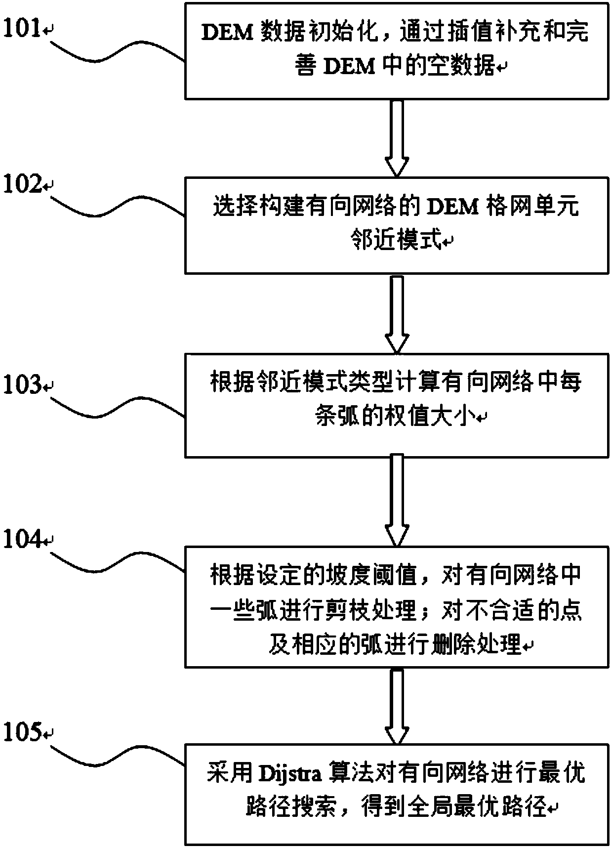
[0043] The technical solutions of the present invention will be described in detail below, but the protection scope of the present invention is not limited to the embodiments.

[0044] Such as figure 1 Shown, a kind of terrain route planning method based on directed network of the present invention comprises the following steps:

[0045] Step 1, DEM data initialization: scan the DEM grid elevation data according to the accuracy requirements, analyze whether there is empty data on some grid units, and if so, perform interpolation calculation to obtain the elevation data of this unit;

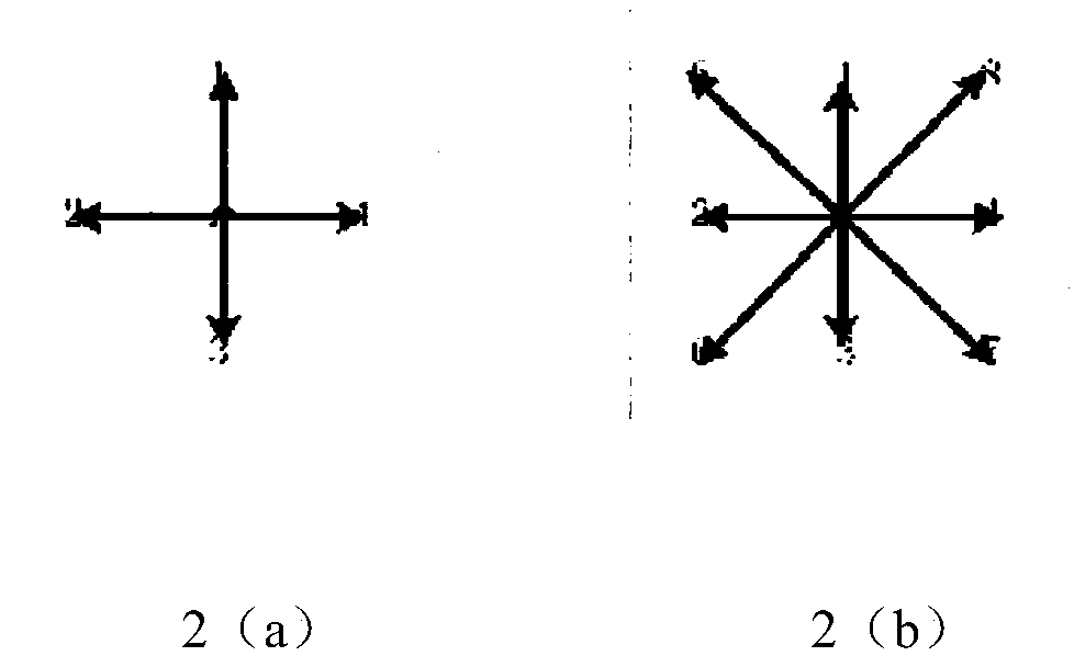
[0046] Step 2, select the proximity calculation mode: according to the path search accuracy requirements, select the grid cell proximity calculation mode for constructing the directed network, the proximity calculation mode types include 4 grid cell proximity mode (low precision) and 8 grid cell proximity mode (High precision);

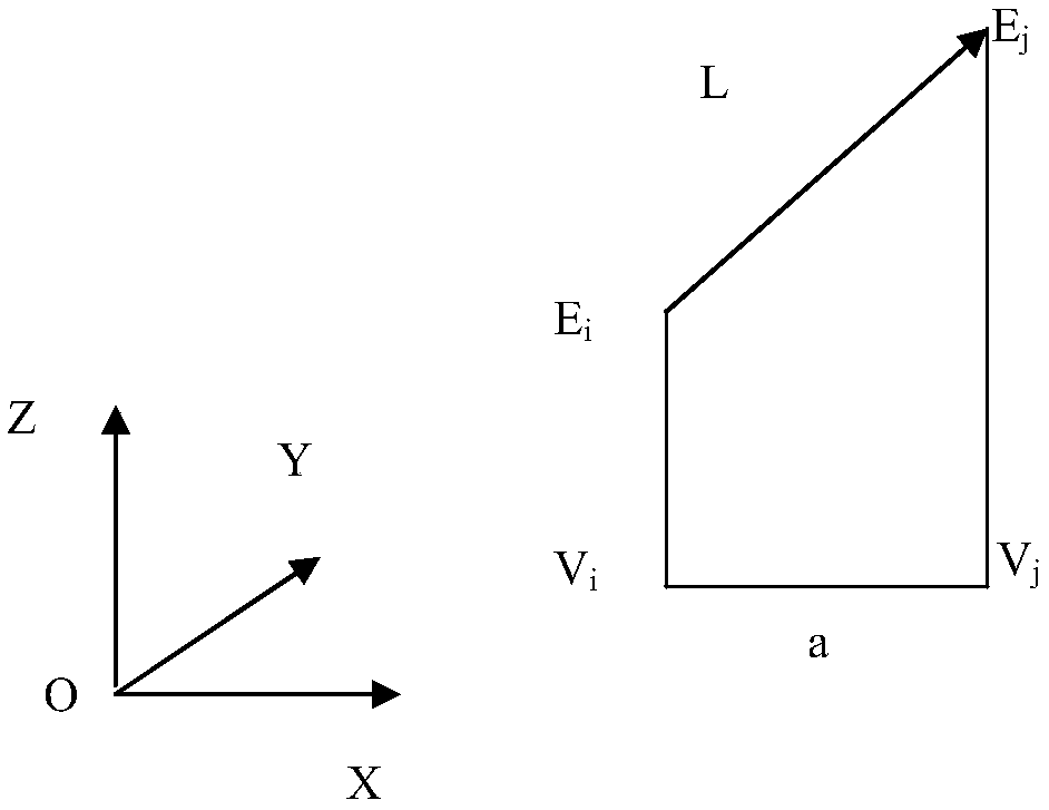
[0047] Step 3, calculate the weight of the arc connecting the ver...


PUM


Abstract

The invention discloses a terrain path planning method based on a directed network. The method comprises the following steps that: (1) carrying out data preparation, and scanning DEM (Digital Elevation Model) regular square grid data; (2) selecting a unit adjacency mode constructed by the directed network; (3) constructing a primary directed network; (4) carrying out pruning processing to obtain the effective directed network; and (5) carrying out path planning, giving a starting point and an end point, adopting a Dijsktra algorithm to carry out path searching on the directed network, and finally, obtaining a globally optimal terrain path. The method can be completely applied to the optimal path planning application of a terrain analysis field of large-scale mass data, and can be used forimproving the efficiency and the global optimum of path planning.

Description

technical field [0001] The invention belongs to digital terrain analysis technology, in particular to a terrain path planning method based on a directed network. Background technique [0002] Path planning has always been a research hotspot in the fields of geographic information science, computer science, operations research, and transportation. Many practical problems can be abstracted as network path planning problems, and its research has major practical value. The existing shortest path planning algorithm can realize the path planning problem well, but when the shortest path algorithm is applied to solve complex network problems, such as network flow optimization, resource allocation, etc., there are still disadvantages of low computational efficiency. [0003] Terrain path planning refers to finding the shortest route with a given starting point and end point on a three-dimensional terrain, which is widely used in traffic route planning, robot path selection and other...

Claims


Application Information

Patent Timeline
Patent Type & Authority Applications(China)
IPC IPC(8): G06F17/50G06Q10/04
CPCG06F30/20G06Q10/047
Inventor 窦万峰王艳丽
Owner NANJING NORMAL UNIVERSITY
Why Eureka
Try Eureka