Image semantic segmentation-based sea-sky-line detection method

A sea-line detection and semantic segmentation technology, applied in the field of image processing, can solve the problems of sea-line detection results error, sea-line cannot be effectively extracted from coastlines, and difficult to meet practical application requirements, etc., and achieves high accuracy and robustness. The effect of small distractions

Inactive Publication Date: 2018-03-16
SHANGHAI UNIV
View PDF1 Cites 20 Cited by
  • Summary
  • Abstract
  • Description
  • Claims
  • Application Information

AI Technical Summary

Problems solved by technology

However, due to the complex and changeable sea surface environment, the gray levels of seawater and sky areas are usually non-uniformly distributed, and it is difficult to accurately segment these two areas using the Otsu segmentation method, resulting in large errors in the final sea antenna detection results.
In addition, when there is a long coast background in the sea surface image, most of the existing sea antenna detection algorithms cannot effectively extract the coastline, which is difficult to meet the needs of practical applications

Method used


Image

  • Image semantic segmentation-based sea-sky-line detection method
  • Image semantic segmentation-based sea-sky-line detection method
  • Image semantic segmentation-based sea-sky-line detection method

Examples


Embodiment 1

[0073] A sea antenna detection method based on image semantic segmentation disclosed in the present invention will be described below with an example. The present embodiment adopts C++ programming language and OpenCV storehouse to realize, and concrete implementation steps are as follows:

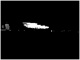
[0074] (1) Input the color sea surface image to be detected;

[0075] The sea surface image to be detected is a 24-bit RGB digital image with a resolution of 640x480, such as Figure 2a shown.

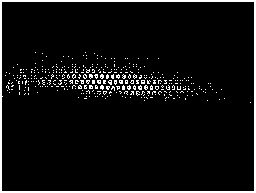
[0076] (2) Using Simple Linear Iterative Clustering Algorithm (SLIC) to perform superpixel segmentation on the input image;

[0077] Use the SLIC algorithm to perform superpixel segmentation on the input image, such as Figure 2b shown. Among them, the number of expected superpixels is set to 1500, and the number of superpixels finally generated may be slightly less than 1500 according to the actual pixel distribution of the image.

[0078] (3) Using superpixels as the basic unit, establish a p...

Embodiment 2

[0113] Fig. 3 is a preferred embodiment of the detection method of the present invention coastline. Its specific implementation steps are the same as those in Embodiment 1, so they are not repeated here. From the detection results of Embodiment 1 and Embodiment 2, it can be seen that the present invention can still detect the sea antenna or coastline in the sea surface image more accurately when there are clouds in the low altitude and islands and land in the distance.


PUM


Abstract

The invention discloses an image semantic segmentation-based sea-sky-line detection method. The method mainly includes the following steps that: (1) a to-be-detected image is inputted; (2) super-pixelsegmentation is performed on the inputted image by using the SLIC (Simple Linear Iterative Clustering) algorithm; (3) with super pixels as basic units, a probability graphical model for sea surface image semantic segmentation is established, and the image is segmented into a sky region, a land and haze mixed region and a seawater region from top to bottom through using the graphical model; (4) the seawater region is extracted, the mask image of the seawater region is obtained; (5) the demarcation points of the seawater region are extracted from the mask image of the seawater region accordingto the gradient information of a column direction; and (6) the RANSAC (Random Sample Consensus) algorithm is adopted to linearly fit the demarcation points of the seawater region, so that the linear parameter of a sea-sky-line can be determined. The image semantic segmentation-based sea-sky-line detection method of the invention not only can accurately detect a sea-sky-line in a complex environment, but also can effectively detect a coastline under a long seashore background, and has high accuracy and robustness.

Description

technical field [0001] The invention relates to the technical field of image processing, in particular to a sea antenna detection method based on image semantic segmentation. Background technique [0002] Sea antenna detection is an important research content of sea surface image processing. In the sea-air background image, if there are close-range targets on the sea surface, all or part of these targets must appear in the area below the sea antenna. Due to the above characteristics of the sea surface image, using the sea antenna information to guide the detection of close-range targets on the sea surface can reduce the detection range of the target on the one hand, thereby improving the execution efficiency of the algorithm, and on the other hand can eliminate the interference of clouds and haze in the sky , so as to improve the accuracy of target detection. [0003] At present, many scholars at home and abroad have studied the sea-antenna detection technology and propose...

Claims


Application Information

Patent Timeline
Patent Type & Authority Applications(China)
IPC IPC(8): G06T7/13G06T7/11
CPCG06T7/11G06T7/13G06T2207/30181
Inventor 刘靖逸李恒宇陈金波谢少荣罗均
Owner SHANGHAI UNIV
Why Eureka
Try Eureka