Forest single tree height estimation method based on lidar point cloud and synchronous remote sensing images

A remote sensing image and tree height technology, which is applied in the field of single tree height estimation in forests, can solve the problem of lack of solutions for airborne LiDAR data, and achieve the effect of improving accuracy

Active Publication Date: 2021-05-18
FUZHOU UNIV
View PDF2 Cites 0 Cited by
  • Summary
  • Abstract
  • Description
  • Claims
  • Application Information

AI Technical Summary

Problems solved by technology

However, the current research is mainly limited to areas with flat terrain and relatively independent trees. There is no corresponding solution for mountainous areas with high canopy density and steep slopes and for airborne LiDAR data with low sampling density.

Method used


Image

  • Forest single tree height estimation method based on lidar point cloud and synchronous remote sensing images
  • Forest single tree height estimation method based on lidar point cloud and synchronous remote sensing images
  • Forest single tree height estimation method based on lidar point cloud and synchronous remote sensing images

Examples


Embodiment Construction

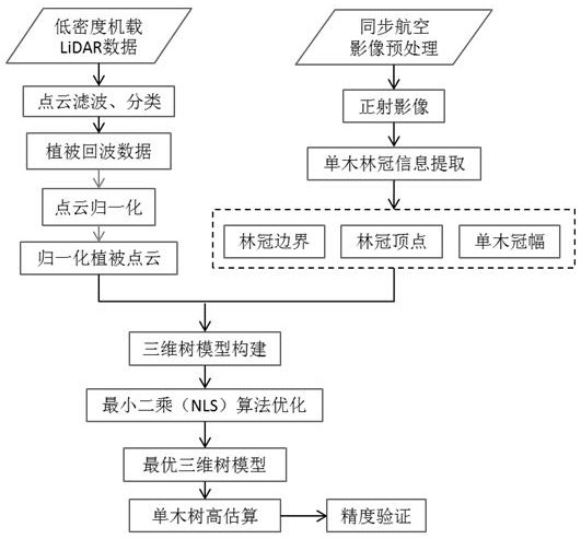
[0030] In order to allow those skilled in the art to better understand the technical solutions of the present invention, the present invention will be further described below in conjunction with the accompanying drawings and specific embodiments.

[0031] The present invention adopts the following technical scheme: a method for estimating the height of a forest single tree in combination with low-density airborne LiDAR point clouds and synchronous remote sensing images, which includes the following steps:

[0032] Step S1: Obtain low-density airborne LiDAR point cloud data and synchronized high spatial resolution aerial remote sensing images in forest areas

[0033] Step S2: By mosaicing and orthorectifying the synchronous aerial remote sensing images of the target area, a digital orthophoto map (DOM) of the target area is obtained, and the matching error between the image and the low-density airborne LiDAR point cloud data is required to be less than a;

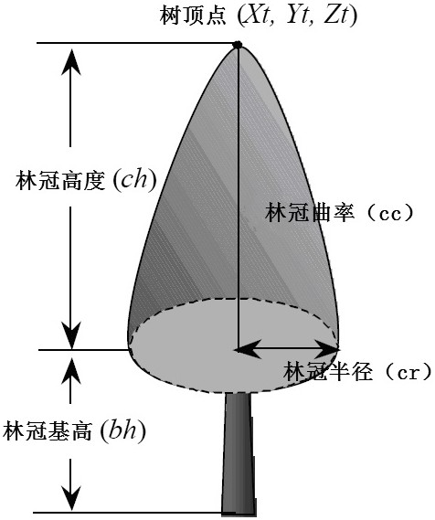
[0034] Step S3: Obta...


PUM


Abstract

The invention relates to a method for estimating the height of a single tree in a forest by combining LiDAR point clouds and synchronous remote sensing images: obtaining low-density airborne LiDAR point cloud data and synchronous high-resolution aerial remote sensing images in forest areas. By mosaicing and orthorectifying the synchronous aerial remote sensing images of the target area, the digital orthophoto map DOM of the target area is obtained; the single tree canopy position, canopy boundary information and single tree canopy information are obtained from the digital orthophoto map; The airborne LiDAR point cloud data is processed, combined with the obtained single tree canopy information to obtain the point cloud data corresponding to the single tree canopy; based on the above results, a three-dimensional tree height model is constructed; according to the number of laser points in the single tree canopy is greater than 1 , equal to 1 and no laser point to optimize and reconstruct the three-dimensional tree model, so as to calculate the height value of the corresponding forest canopy vertex. Raise the tree height estimation level to the single tree level, and effectively improve the accuracy of forest stand single tree height estimation.

Description

technical field [0001] The invention relates to a method for estimating the height of a single tree in a forest by combining low-density airborne LiDAR point clouds and synchronous remote sensing images. Background technique [0002] As one of the most important parameters in forest structure parameters, forest tree height information is the basis for inversion estimation of other forest parameters. At present, scholars at home and abroad have done a lot of research on using lidar data to extract forest tree height information. However, due to the influence of point cloud sampling density and forest habitat, most of them focus on the extraction of tree height information from high-density point cloud data, while There is a lack of research on low-density point cloud data. To this end, the present invention proposes to combine LiDAR data with synchronously acquired high-resolution aerial images, fully excavate and utilize the canopy elevation information provided by low-dens...

Claims


Application Information

Patent Timeline
Patent Type & Authority Patents(China)
IPC IPC(8): G06T7/60G06T17/05G06T17/20G06K9/00G01B11/06
CPCG06T15/005G01B11/0608G06T2207/10028G06V20/188
Inventor 周小成鲁林黄洪宇
Owner FUZHOU UNIV
Why Eureka
Try Eureka