Grid processing method for basin complex terrain

A processing method and technology for complex terrain, applied in image data processing, electrical digital data processing, special data processing applications, etc., can solve problems such as grid processing difficulties

Active Publication Date: 2018-04-03
WUHAN UNIV
View PDF4 Cites 2 Cited by
  • Summary
  • Abstract
  • Description
  • Claims
  • Application Information

AI Technical Summary

Problems solved by technology

However, there are still many difficulties in the grid processing of complex river terrains with narrow main channels but wide inlets, right-angle bends and U-shaped bends, Niuer lakes, sharp channel shrinkage, and Niuer lakes with inflow branches.
According to the irregular characteristics of terrain changes and actual needs, for river sections with huge terrain changes, the grid processing of river sections is very important. If the grid is not handled properly, the direction of the main grid does not match the river topography, it will not be able to overcome the complex Numerical simulation of water flow under terrain conditions faces difficulties such as calculation instability and poor format harmony

Method used


Image

  • Grid processing method for basin complex terrain
  • Grid processing method for basin complex terrain
  • Grid processing method for basin complex terrain

Examples


Embodiment Construction

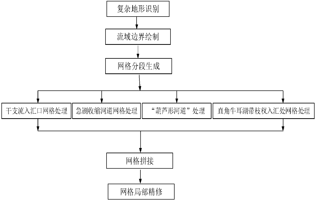
[0062] The grid processing method for the complex terrain of the watershed involved in the present invention will be described in detail below in conjunction with the accompanying drawings.

[0063]

[0064] Such as figure 1 As shown, the grid processing method for the complex topography of the watershed provided by this embodiment includes the following contents:

[0065] (1) Grid processing method of trunk and branch inflows and confluences

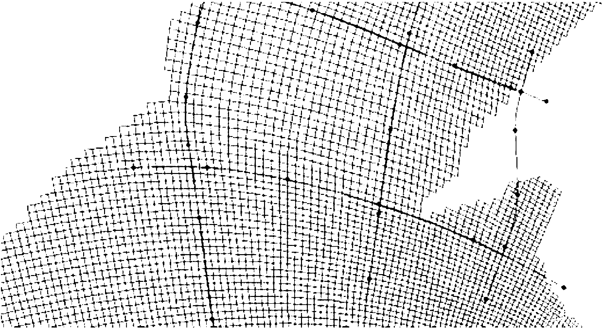
[0066] The grid processing method of main and tributary inflows and confluences refers to the grid processing method for drawing and splicing the grids of tributaries and main streams with relatively complex terrain and conforming to the actual terrain conditions. The method specifically includes the following steps:

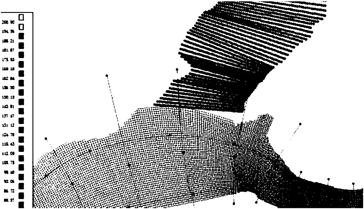
[0067] ①Grids are generated separately for main and tributary streams: such as figure 2 As shown, according to the terrain at the inlet and outlet of the main and tributary rivers, use the existing grid drawing tool ...


PUM


Abstract

The invention provides a grid processing method for a basin complex terrain. Through the method, standard, reasonable and simple processing of grids of the complex terrain can be realized. The methodis characterized by comprising (1) a grid processing method for confluence of trunk streams and tributaries, wherein a riverway relation within a research range is recognized, trunk riverway parts andbranch riverway parts are divided, and a riverway is segmented; two-dimensional grids of the trunk streams and the tributaries within a basin range are drawn respectively according to river reaches,two-dimensional grid data of each river reach is obtained, then splicing positions are judged according to a terrain trend and an adjacent relation at the confluence, and smooth splicing of the gridsat the confluence of the trunk streams and the tributaries is realized; (2) a grid processing method for a sharp contraction position of the riverway; (3) a grid processing method for a gourd-shaped position of the riverway; and (4) a grid processing method for right-angle Ox Ear Lake confluence with branches, wherein local T-shaped grids are drawn for the grids within the research range for mutual splicing.

Description

technical field [0001] The invention belongs to the field of fluid mechanics and environment simulation, and in particular relates to a grid processing method for complex topography of a watershed. technical background [0002] The grid is the premise of discretizing the whole unit and carrying out the finite element numerical refinement simulation calculation. With the continuous development of modern 2D and 3D hydrodynamic water quality models, problems such as complex topographic boundary shapes of calculation areas, large calculation areas, and different grid resolution requirements for different areas are often encountered. In order to carry out the calculation of water flow under complex terrain conditions, without losing the detailed features of the terrain and reducing the amount of calculation data, the structure grid adaptive algorithm can be dynamically changed with the evolution of the water flow, and local encryption and sparseness can be performed according to ...

Claims


Application Information

Patent Timeline
Patent Type & Authority Applications(China)
IPC IPC(8): G06F17/50G06T11/20G06T17/20
CPCG06F30/23G06F2119/06G06T11/203G06T17/20
Inventor 张万顺夏函王永桂刘宏宽彭虹
Owner WUHAN UNIV
Why Eureka
Try Eureka