Whole-space information system-oriented coordinate system conversion method

A technology of coordinate system transformation and information system, applied in geographic information database, program control design, structured data retrieval, etc., can solve the problem of seamless transformation of the whole space information system, achieve good scalability, good Achieve efficiency, improve accuracy and reliability results

Inactive Publication Date: 2018-04-06
ZHENGZHOU NORMAL UNIV
View PDF5 Cites 11 Cited by
  • Summary
  • Abstract
  • Description
  • Claims
  • Application Information

AI Technical Summary

Problems solved by technology

Spatial reference has been deeply researched and implemented in traditional GIS. Software and organizations such as Proj4, ArcGIS, OGC, and EPSG have described and implemented spatial reference in detail, but these descriptions are mainly for the geographic coordinate system and projection of earth space. The coordinate system cannot solve the complex space seamless transformation problem of the whole space information system, which expands from earth space to cosmic space, from macro space to micro space, and from a single planet space to many planet spaces.

Method used


Image

  • Whole-space information system-oriented coordinate system conversion method
  • Whole-space information system-oriented coordinate system conversion method
  • Whole-space information system-oriented coordinate system conversion method

Examples


Embodiment Construction

[0032] In order to make the purpose, technical solution, and advantages of the present invention more clear, the present invention will be further described in detail below in conjunction with the accompanying drawings.

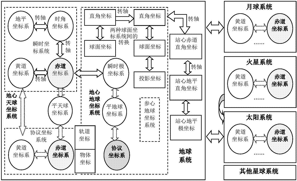
[0033] The specific implementation of the present invention is as follows: first define the description method of the spatial reference of the whole spatial information system, then design the coordinate system conversion framework of the whole spatial information system on this basis, and finally realize the conversion between the coordinate systems through the spatial reference tree. Specific steps are as follows:

[0034] 1. Input the measuring point coordinates

[0035] The measuring point coordinates are earth coordinate points or planetary coordinate points, and the acquisition of the measuring point coordinates includes GPS measurement or Beidou satellite navigation system measurement or vector acquisition, etc., and the measurement accuracy ca...


PUM


Abstract

The invention provides a whole-space information system-oriented coordinate system conversion method, and belongs to the field of geospatial information visualization. A space conversion framework ofa whole-space information system is established, and description of WKT on a space reference system is extended to enable the same to support definition of planets and coordinate systems of celestial-sphere coordinate systems, orbit coordinate systems and the like; and a space reference memory model based on a nine-degree-of-freedom space reference tree is designed, and thus maintenance of the space reference tree, calculation of relative status and plug-in realization of the coordinate system conversion method are realized. The method can effectively solve continuous whole-space-time modelingand simulation of the whole-space information system from macroscopic worlds (such as stars and planets in a solar system) to microcosmic worlds (such as indoor environments), from static status to dynamic status and from physical space-time to logical space-time, has good scalability and realization efficiency, and can be widely applied to many fields of satellite positioning and navigation, aerospace remote-sensing, smart cities, territorial planning, military application and the like.

Description

technical field [0001] The invention belongs to the field of geographic space information visualization, and relates to a coordinate system conversion method oriented to the whole space information system. Background technique [0002] After more than 50 years of development, GIS has developed into a comprehensive high-tech field including geographic information science, geographic information technology, and geographic information applications. It has been widely used in the fields of life and health, planning and regional design, and has become an indispensable part of today's information society. However, traditional GIS mainly studies the earth's surface system, focusing on the surface space closely related to human production and life. With the rapid development of technology, traditional GIS has gradually exposed its shortcomings and is facing new opportunities and challenges. For this reason, scholars represented by academician Zhou Chenghu of the Chinese Academy of...

Claims


Application Information

Patent Timeline
Patent Type & Authority Applications(China)
IPC IPC(8): G06F9/445G06F17/30
CPCG06F9/44526G06F16/29
Inventor 武玉国杜莹蒲欢欢马亚明孙汀韦原原
Owner ZHENGZHOU NORMAL UNIV
Why Eureka
Try Eureka