Unmanned aerial vehicle flight control system on basis of CORS (continuously operating reference station) network differential positioning

A flight control system and unmanned aerial vehicle technology, applied in satellite radio beacon positioning system, traffic control system, control/regulation system, etc. The effect of distance positioning accuracy reduction

Pending Publication Date: 2018-05-04
SHANGHAI HUACE NAVIGATION TECH
View PDF0 Cites 10 Cited by
  • Summary
  • Abstract
  • Description
  • Claims
  • Application Information

AI Technical Summary

Problems solved by technology

At present, the existing RTK differential flight control systems on the market mostly use self-installed base stations, and the RTK differential positioning scheme in which radio stations transmit differentia

Method used


Image

  • Unmanned aerial vehicle flight control system on basis of CORS (continuously operating reference station) network differential positioning

Examples


Embodiment Construction

[0023] In the following description, numerous specific details are given in order to provide a more thorough understanding of the present invention. It will be apparent, however, to one skilled in the art that the present invention may be practiced without one or more of these details. In other examples, some technical features known in the art are not described in order to avoid confusion with the present invention.

[0024] In order to thoroughly understand the present invention, detailed steps and detailed structures will be provided in the following description, so as to illustrate the technical solution of the present invention. Preferred embodiments of the present invention are described in detail below, however, the present invention may have other embodiments besides these detailed descriptions.

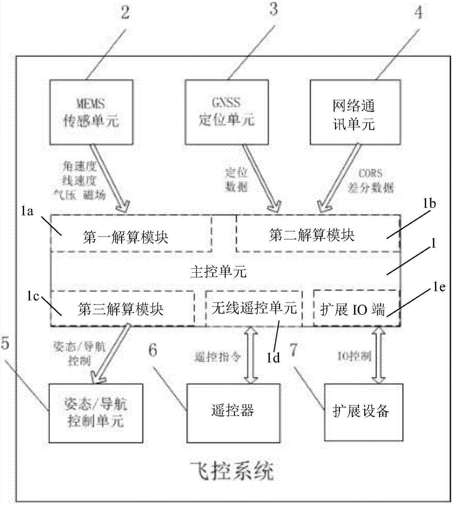
[0025] The invention provides a UAV flight control system based on CORS network differential positioning, including:

[0026] MEMS sensing unit 2, used to collect angular v...


PUM


Abstract

The invention provides an unmanned aerial vehicle flight control system on the basis of CORS (continuously operating reference station) network differential positioning. The unmanned aerial vehicle flight control system comprises an MEMS (micro-electromechanical system) sensing unit, a GNSS (global navigation satellite system) positioning unit, a network communication unit, an attitude/navigationcontrol unit and a master control unit. The MEMS sensing unit is used for acquiring angular velocity, linear velocity, air pressure and magnetic field data; the GNSS positioning unit is used for acquiring GNSS positioning data; the network communication unit is used for acquiring CORS differential data; the attitude/navigation control unit is used for controlling attitude and navigation of unmanned aerial vehicles; the master control unit is used for carrying out operation such as data processing, data fusion and system control between various functional units. The unmanned aerial vehicle flight control system has the advantages that the CORS base station differential data can be acquired by the aid of 3G (the 3rd generation telecommunication) networks, RTK (real-time kinematic) differential positioning of the unmanned aerial vehicle flight control system can be implemented, and centimeter-level positioning accuracy requirements of high-end consumption unmanned aerial vehicles and professional surveying and mapping unmanned aerial vehicles can be met; difference can be quickly and efficiently acquired by the aid of CORS networks as compared with RTK differential positioning schemesfor transmitting differential data by the aid of self-erected base stations and radio stations, the shortcomings of deterioration of long-distance positioning precision of radio station transmissionmodes and limited communication distances of the radio stations can be overcome, and the unmanned aerial vehicle flight control system conforms to the future RTK differential data network developmenttrend.

Description

technical field [0001] The invention relates to the field of GNSS receiver measurement, in particular to an unmanned aerial vehicle flight control system based on CORS network differential positioning. Background technique [0002] With the development of information technology, unmanned aerial vehicles have entered the field of consumer electronics from the military industry field, especially the rotor UAV market has shown a blowout growth in recent years. The demand is also growing stronger. Different from the manual control of toy drones, high-end consumer drones, professional surveying and mapping drones, etc. have higher and higher requirements for the automation and flight accuracy of drones, and the precise calculation of position information by the flight control system becomes its key. [0003] At present, GPS single-point positioning is usually used for UAV positioning, and the positioning accuracy is at the meter level, which is far from meeting the centimeter-l...

Claims


Application Information

Patent Timeline
IPC IPC(8): G01S19/49G01S19/41G05D1/10
CPCG01S19/41G01S19/49G05D1/101G01S19/42G01S19/43G01S19/52G01S19/53G05D1/10B64C39/024G08G5/0069B64U2201/10
Inventor 董胜飞王杰俊李彩萌谢华忠何伟
Owner SHANGHAI HUACE NAVIGATION TECH
Why Eureka
Try Eureka