Method for rapidly making safeguard risk maps of water resources of China in batches on basis of database drive

A database and water resource technology, applied in geographic information databases, resources, data processing applications, etc., can solve the problems of lack of map mapping mechanism, cumbersome mapping data update process, difficult consistency maintenance, etc., to achieve the benefit of incremental update and Multiple expressions, improving the lack of thematic symbols, and realizing the effect of integrated management

Pending Publication Date: 2018-05-08
BEIJING FORESTRY UNIVERSITY +1
View PDF7 Cites 7 Cited by
  • Summary
  • Abstract
  • Description
  • Claims
  • Application Information

AI Technical Summary

Problems solved by technology

The disadvantages of these strategies are: GIS lacks a map-making mechanism; the relationship between geographical elements and map elements is separated, and the acquisition function of geographic data is lacking in the map-making stage. When geographic data needs to be updated, expensive remedial measures have to be taken to repeatedly apply GIS data ; Repeated export and import of data is time-consuming and increases redundancy, and in multiple expressions, it is necessary to update data repeatedly for two systems, making it difficult to maintain consistency
[0003] At present, China does not have a complete water resource risk assurance map and its production method. The general mapping method cannot provide sufficient and targeted materials for this application, and the mapping method has problems such as simplification and cumbersome updating process of the mapping data.

Method used


Image

  • Method for rapidly making safeguard risk maps of water resources of China in batches on basis of database drive
  • Method for rapidly making safeguard risk maps of water resources of China in batches on basis of database drive
  • Method for rapidly making safeguard risk maps of water resources of China in batches on basis of database drive

Examples


preparation example Construction

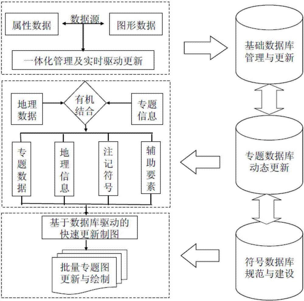
[0032] Step 3. Preparation of thematic data:

[0033] Using the original data of the vector layer of the second-level national water resources area and the vector layer of the national provinces, 197 evaluation units of the national second-level area and province were generated, and the thematic layer data was generated by using the union method in ArcGIS. According to the requirements of cartography, draw The national water resources thematic map of sub-provinces and the national water resources thematic map of secondary districts and provinces;

[0034] Step 4. Set the drawing size and drawing range:

[0035] Create a new drawing output layout, and set the layout size according to the scale and printer model, and set the position and size of the drawing according to the shape of the Chinese region and traditional drawing habits;

[0036] Step 5. Expression and display of thematic data:

[0037] Define feature classes, draw thematic layers, and use automatic labeling method...

specific Embodiment

[0065] (1) Production of national border symbols

[0066] Legend files are usually saved in the *.style format in ArcGIS, and are created and managed through the style management tool set (with the functions of Style References, Style Manager, and Export MapStyles) under the path of Arcmap—>Tools—>Styles. After the Style Manager is called up, the Symbol PropertyEditor interface can be called up to make legends.

[0067] The specific production steps of national border symbols are as follows:

[0068] 1. In the list on the left side of Style Manager, expand the ESRI.Style folder, select the Symbol type to be created, the national border line element, and select the Line Symbol file. Then right click in the list on the right -> New to create a new line element. The national border symbol of this patent is composed of 4 line types, from top to bottom, they are short vertical line, short horizontal line with dots, purple halo line and light pink halo line.

[0069] 3. Productio...


PUM


Abstract

The invention discloses a method for rapidly making safeguard risk maps of water resources of China in batches on the basis of database drive. By drive of a basic geographic database, a thematic database and a cartographic coincidence library, thematic maps are updated in batches, including making of legend items, a data preparation process, preparation of thematic data, size and drawing range ofset graphs, expression and displaying of thematic data, map finishing and layout and map outputting. Correction and storage of map target object level are facilitated; data redundancy is reduced; batched updating and multi-expression of maps are facilitated; and meanwhile, a traditional GIS map expression ability is convenient to extend. Integrated management of an attribute database and a graphic database and automatic configuration of a thematic map making data model and drawing symbols are realized, the bottleneck of shortage of thematic symbols, troublesome data updating and the like in existing drawing is improved, and the method is a rapid and effective method for drawing safeguard risk maps of water resources of China in batches, and can provide reference for thematic drawing of development of the national economy of China and national defense construction.

Description

technical field [0001] The invention relates to a method for computer digital drawing, in particular to a method for rapidly batch-making China's water resources security risk map based on database driving. Background technique [0002] At present, in the field of map information acquisition, transformation, storage, processing, analysis and graphic output, due to the lack of basic map design theory by some GIS users and the lack of sufficient map expression tools in GIS software itself, many maps produced by GIS The graphics are difficult to fully meet the needs. The symbolization of the map is completed in the GIS software, but the final stage of the map product has to be completed in the publishing software without the GIS database, and the workflow is interrupted; or two sets of data are used: one for map drawing and one for geography For analysis, data production units need to produce two versions of data. The disadvantages of these strategies are: GIS lacks a map-mak...

Claims


Application Information

Patent Timeline
Patent Type & Authority Applications(China)
IPC IPC(8): G06F17/30G06Q10/06
CPCG06Q10/0635G06F16/29G06F16/56
Inventor 张学霞郑景云齐元静吴文祥方宇高跃鹏张殿君张雪杨璐璐
Owner BEIJING FORESTRY UNIVERSITY
Why Eureka
Try Eureka