Silt tidal flat topography evolution method based on oblique photographing three-dimensional reconstruction technology

A technology of three-dimensional reconstruction and oblique photography, which is used in satellite radio beacon positioning systems, measuring devices, instruments, etc.

Inactive Publication Date: 2018-05-18
HOHAI UNIV
View PDF4 Cites 17 Cited by
  • Summary
  • Abstract
  • Description
  • Claims
  • Application Information

AI Technical Summary

Problems solved by technology

[0004] The purpose of the present invention is to provide a muddy tidal flat terrain evolution method based on oblique photographic three-dimensional reconstructio...

Method used


Image

  • Silt tidal flat topography evolution method based on oblique photographing three-dimensional reconstruction technology
  • Silt tidal flat topography evolution method based on oblique photographing three-dimensional reconstruction technology
  • Silt tidal flat topography evolution method based on oblique photographing three-dimensional reconstruction technology

Examples


Embodiment Construction

[0035] The present invention will be described in detail below in combination with specific embodiments.

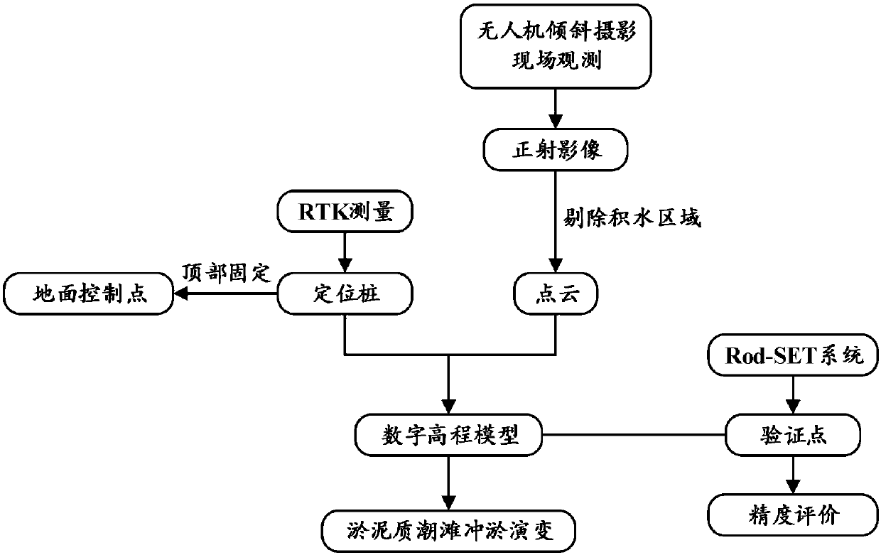
[0036] The present invention as figure 1 shown, including the following steps:

[0037] Step 1, determine the monitoring range and monitoring time range of muddy tidal flat topography;

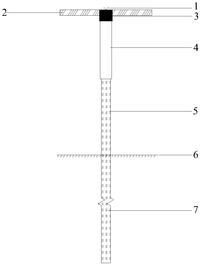
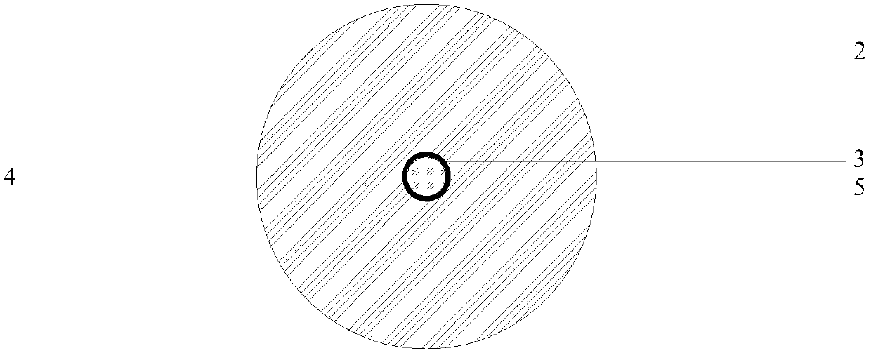
[0038] Step 2: Install positioning piles evenly in the area, use the Z-Max dual-frequency GPS-RTK positioning system to measure the elevation of the pile top control points, and re-measure after a period of time to ensure that no settlement occurs in the short term;

[0039] Step 3, fix the flying disc on the fixed point pile as the control point of the drone;

[0040] Step 4, plan the flight route of the UAV in the monitoring area, and fly once from four different directions with the camera lens tilted at an angle of 45 degrees, and the flight directions are perpendicular to each other;

[0041] Step 5, use drones in the monitoring area to collect aerial photos of the area;

[0042] ...


PUM


Abstract

The invention discloses a silt tidal flat topography evolution method based on an oblique photographing three-dimensional reconstruction technology. The silt tidal flat topography evolution method comprises the following steps: planning an air route of an unmanned aerial vehicle in a target measurement region of a tidal flat and distributing and uniformly driving positioning piles in the region; fixing a flying disc on the piles to be used as a control point; carrying out static data acquisition on the control point by adopting a GPS (Global Positioning System); acquiring aerial photographs ofthe region by utilizing the unmanned aerial vehicle; generating a point cloud and an ortho-image of the region through the photographs photographed by the unmanned aerial vehicle by utilizing three-dimensional modeling software; identifying a water ponding region from the ortho-image and eliminating the water ponding region from point cloud data; coupling acquired static data into the processed point cloud data and establishing a three-dimensional model of the region, so as to obtain tidal flat elevation information of the region; verifying model errors by utilizing a Rod-SET system; carryingout periodic monitoring modeling on the same region, so as to monitor scour and silting evolution of the region. The silt tidal flat topography evolution method disclosed by the invention has the beneficial effect that the elevation precision of topography measurement reaches a centimeter grade.

Description

technical field [0001] The invention belongs to the technical field of geological survey, and relates to a muddy tidal flat terrain evolution method based on oblique photography three-dimensional reconstruction technology. Background technique [0002] my country's tidal flats are widely distributed, and large-scale land reserve resources can be formed through reclamation and development. Since the mid-1980s, one of the advances in the study of tidal flat sedimentation is the field observation of the tidal flat deposition process and landform evolution. The muddy tidal flat is wide, flat, and the water depth is small, and the nonlinear effects of tidal currents and waves on the beach surface are strong; silt, silt, sand and other substrates are clearly sorted in the horizontal direction of the tidal flat, and the law of sediment movement is in the horizontal direction of the tidal flat. Larger changes. Therefore, a reliable on-site topographic measurement method is needed ...

Claims


Application Information

Patent Timeline
IPC IPC(8): G01C11/02G01S19/13
CPCG01C11/02G01S19/13
Inventor 戴玮琦李欢赵堃张长宽路翠卓杨华韬李定远耿亮张孝严
Owner HOHAI UNIV
Why Eureka
Try Eureka