Rapid monitoring method of large-scale land desertification

A large-scale, land-based technology, applied in soil material testing, material inspection products, etc., can solve the problems of complex, labor-intensive, and time-consuming data processing, and achieve the effect of avoiding workload.

Inactive Publication Date: 2018-05-18
INST OF GEOGRAPHICAL SCI & NATURAL RESOURCE RES CAS
View PDF3 Cites 4 Cited by
  • Summary
  • Abstract
  • Description
  • Claims
  • Application Information

AI Technical Summary

Problems solved by technology

[0005] Looking at the above dynamic desertification monitoring methods, most of them focus on the regional scale. Although the results are relatively accurate, if they are applied to the ...

Method used


Image

  • Rapid monitoring method of large-scale land desertification
  • Rapid monitoring method of large-scale land desertification
  • Rapid monitoring method of large-scale land desertification

Examples


Embodiment 1

[0046] Example 1: Example area preparation

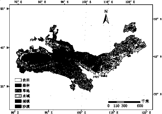
[0047] Such as figure 1 As shown, the desertification areas in northern China mainly involve 222 counties in northern extreme arid, arid, semi-arid, and semi-humid areas such as Inner Mongolia, Xinjiang, Qinghai, Gansu, Sichuan, Ningxia, Shanxi, and Shaanxi.

[0048] The desertification distribution zone is roughly between 77°14´E-122°41´E, 32°43´N-49°35´N, far away from the ocean and deep inland, and the ocean air flow is not easy to reach, forming an obvious temperate zone, frigid zone Temperate continental climate, at the same time, most of these areas have less precipitation, concentrated precipitation, dry climate, strong sunlight, windy weather, sandstorms, rainstorms, droughts and other harsh climate disasters occur frequently.

[0049] According to the geographical location and climate characteristics of the monitoring area, it is divided into three sandy areas: the Northwest arid area, the Sanjiangyuan area, Inner Mongolia...

Embodiment 2

[0055] Example 2: Data preparation

[0056] The data sources used for monitoring are shown in Table 2.

[0057] Considering the lowest resolution among all data, the present invention uniformly resamples or converts all grid and vector data into spatial data with a resolution of 8km×8km.

[0058] Table 2 Basic data sources

[0059] .

Embodiment 3

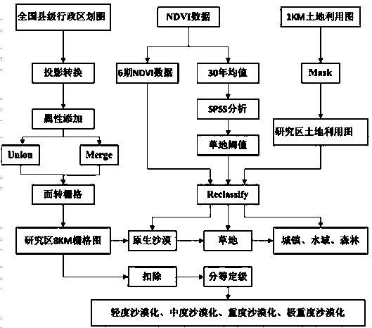
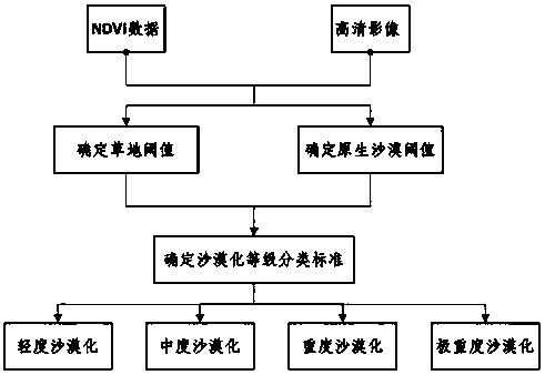
[0060] Example Three: Technical Route

[0061] Using multi-source data, including basic geographic data, multi-temporal remote sensing data, elevation data, land use data, etc. to monitor land desertification in northern China, specific technical routes figure 2 shown. The overall process of desertification monitoring is as follows: image 3 shown.


PUM


Abstract

The invention discloses a rapid monitoring method of large-scale land desertification and aims to develop a rapider and more accurate large-scale desertification monitoring method based on easily available data. The method comprises steps as follows: a research time domain is selected, and the period is divided; a research zone is selected, and changes in a town, a water area, a forest and a farmland in six periods are obtained by use of LUCC data; the average value of NDVI data of recent three years is defined as NDVI data of each period; grassland information and native desert information are acquired through NDVI with a decision tree classification method; a non-desertification region and a native desert region are removed from the research area, so that the desertification region is obtained; 15-degree correction of a slope is performed through auxiliary DEM data. According to the method, easily obtained data are adopted, heavy workload of manual interpretation is avoided, a scientific basis is provided for treatment of desertified land, and the method has great practical significance in guiding desertification control and desertification decision.

Description

technical field [0001] The invention relates to the technical field of ecological protection, in particular to a rapid monitoring method for large-scale land desertification. Background technique [0002] Inner Mongolia, Xinjiang and other parts of our country are deeply troubled by desertification. The impact of desertification on our country mainly includes the following aspects: First, it endangers the development of agriculture. The harm of desertification to agriculture is mainly reflected in the sandy soil, and the seedlings are killed by drought or buried by wind and sand. At the same time, the income of farmers cannot be guaranteed; the second is the harm to the grassland, the degradation of the grassland caused by desertification, the dominant grass species suitable for livestock consumption are gradually reduced, or even completely lost, and the livestock carrying capacity of the pasture is greatly reduced; the third is the harm to water resources, desertification ...

Claims


Application Information

Patent Timeline
IPC IPC(8): G01N33/24
CPCG01N33/24
Inventor 许端阳
Owner INST OF GEOGRAPHICAL SCI & NATURAL RESOURCE RES CAS
Why Eureka
Try Eureka