Patrol robot simultaneous localization and mapping method in underground space based on depth-inertial odometer

A technology for inspection robots and underground spaces, applied in two-dimensional position/channel control, instruments, calculations, etc., can solve problems such as low positioning accuracy, lack of simultaneous positioning and map construction, and weak robustness, and achieve The effect of improving accuracy

Active Publication Date: 2018-05-18
CHINA UNIV OF MINING & TECH
View PDF6 Cites 13 Cited by
  • Summary
  • Abstract
  • Description
  • Claims
  • Application Information

AI Technical Summary

Problems solved by technology

Although the method of using a separate sensor has a small amount of calculation, the positioning accuracy is not high and the robustness is not strong
Simultaneous localization and mapping meth

Method used


Image

  • Patrol robot simultaneous localization and mapping method in underground space based on depth-inertial odometer
  • Patrol robot simultaneous localization and mapping method in underground space based on depth-inertial odometer
  • Patrol robot simultaneous localization and mapping method in underground space based on depth-inertial odometer

Examples


Embodiment Construction

[0039] The present invention will be further described through specific embodiments below in conjunction with the accompanying drawings.

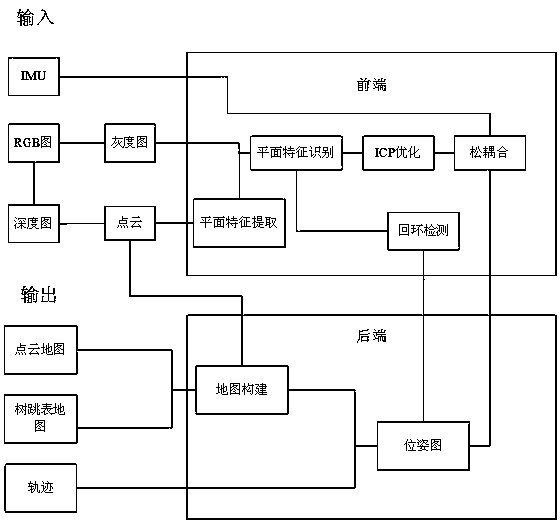
[0040] Such as Figure 1 to Figure 6 As shown, a method for simultaneous localization and map construction of an inspection robot in underground space based on a depth inertial odometer. The simultaneous localization method is: using a depth camera and an inertial measurement unit for loose coupling, and obtaining a point cloud through a depth map collected by a depth camera information to extract plane features. The RGB image collected by the depth camera and the plane feature are fused, and the iterative closest point (ICP) algorithm is used for optimization; the ICP optimized data is loosely coupled with the inertial measurement unit (IMU) data, and the pose is improved by using loop closure (Loop closure) map accuracy, to obtain the inspection robot's running trajectory, point cloud map and tree jump table map.

[0041] The depth came...


PUM


Abstract

A patrol robot simultaneous localization and mapping (SLAM) method in an underground space based on a depth-inertial odometer. The method comprises loosely coupling a depth camera and an inertial measurement unit, acquiring point cloud information through a depth map acquired by the depth camera, and extracting a plane feature; converting an RGB image acquired by the depth camera into a grayscalemap to be fused with the plane feature, using an iterative closest point algorithm for optimization; loosely coupling the data subjected to the iterative closest point optimization and the data of theinertial measurement unit, using loop detection to improve the accuracy of a pose image and to obtain the trajectories of the patrol robot, a point cloud map, and a tree skip list map so as to achieve an indoor SLAM effect of the patrol robot. The method improves the simultaneous localization accuracy and robustness of the patrol robot in the underground space, and has a SLAM effect of the patrolrobot in the underground space. When the patrol robot operates in the underground space, the method has good robustness under a strong rotating environment.

Description

technical field [0001] The invention relates to the field of simultaneous positioning of inspection robots, in particular to a method for simultaneous positioning and map construction of an inspection robot in underground space based on a depth inertial odometer. Background technique [0002] With the advancement of science and technology, inspection robots are more and more widely used in industrial, military and other fields. In many cases, the information of the workspace of the inspection robot is complex and unknown. If the inspection robot wants to realize indoor autonomous navigation, target recognition, automatic obstacle avoidance and other functions, its precise and simultaneous positioning is particularly important. Most of the traditional simultaneous positioning methods are based on the simultaneous positioning of global satellites such as GPS and Beidou, but the simultaneous positioning accuracy of ordinary GPS sensors is low, which cannot meet the precise sim...

Claims


Application Information

Patent Timeline
IPC IPC(8): G05D1/02G06T7/80
CPCG05D1/0251G05D1/0268G06T7/80
Inventor 朱华陈常李振亚汪雷杨汪庆李鹏赵勇由韶泽
Owner CHINA UNIV OF MINING & TECH
Why Eureka
Try Eureka