Sea area information management system based on drone monitoring

An information management system and unmanned aerial vehicle technology, which is applied in the field of Internet of Things development system construction, can solve the problems of unmanned aerial vehicle data network sharing difficulties, untimely sea area management information, and inability to realize data sharing, etc., so as to improve monitoring efficiency and monitor The effect of area enlargement and accurate detection

Inactive Publication Date: 2018-05-25
BEIJING UNIV OF TECH
View PDF3 Cites 19 Cited by
  • Summary
  • Abstract
  • Description
  • Claims
  • Application Information

AI Technical Summary

Problems solved by technology

However, it is difficult to remotely access UAV remote sensing data (including UAV video data, pos positioning data, and UAV positioning and photo data) to the command center in real time and realize network sharing of UAV data.
[0003] At present, the technology adopted at home and abroad is to use microwave communication and satellite communication. These two methods have the following defects: the use of microwave technology for communication, short transmission distance, and unstable signals; and the use of satellite communication is expensive.
This system is a new type of multimedia monitoring technology that can make significant progress in the supervision of sea areas and maritime affairs. It can repair the problems of untimely management information in sea areas and the inability to realize data sharing at this stage.

Method used


Image

  • Sea area information management system based on drone monitoring
  • Sea area information management system based on drone monitoring
  • Sea area information management system based on drone monitoring

Examples


Embodiment Construction

[0024] The present invention will be further described below in conjunction with the accompanying drawings.

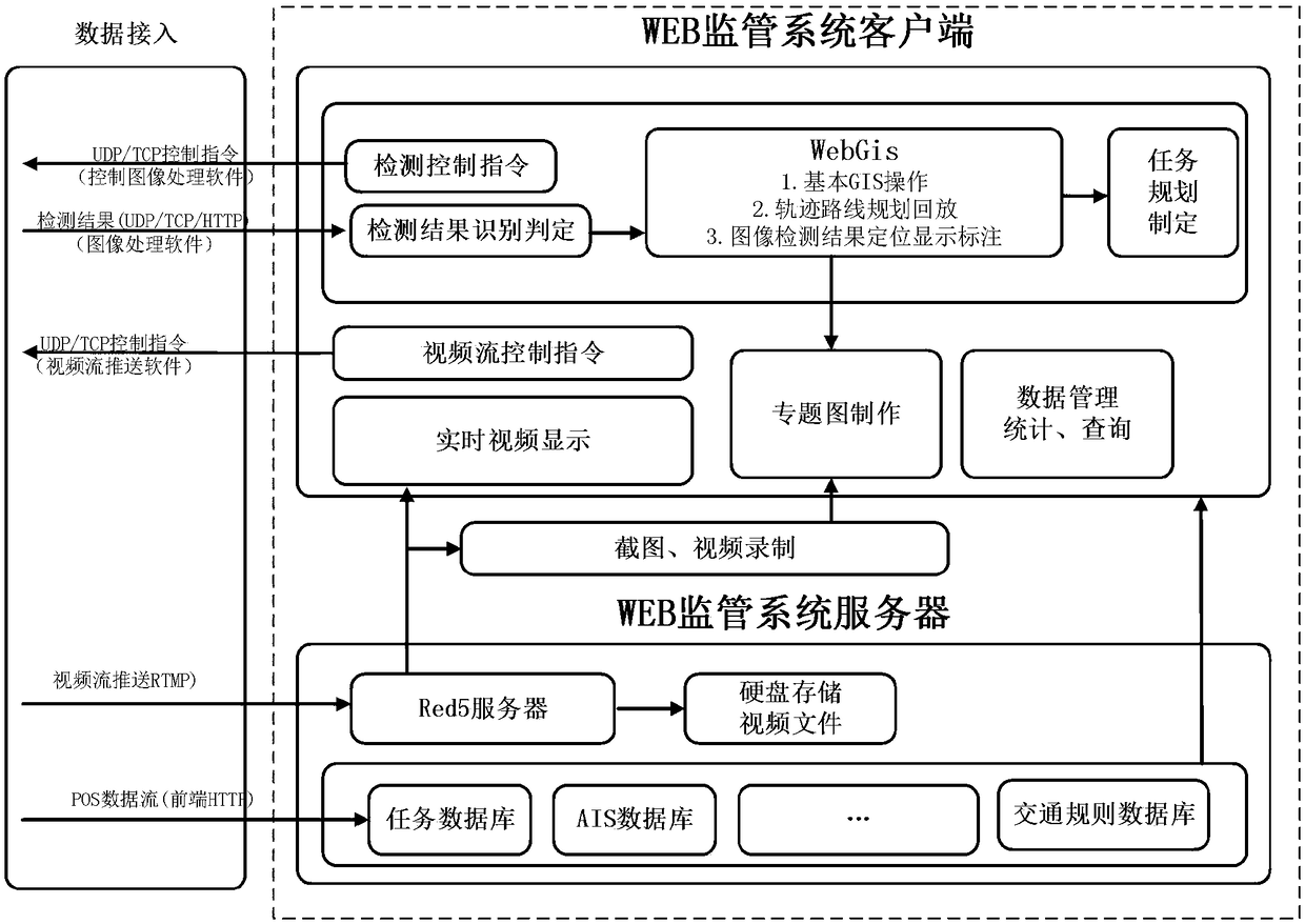
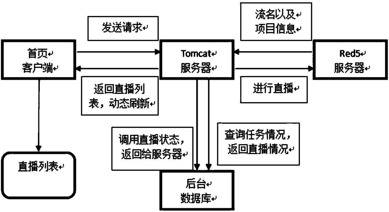
[0025] The design scheme of the system of the present invention is as figure 1 As shown, it is mainly divided into three parts: data access phase, client design, and Web server design. Among them, the transmission method of the data access terminal adopts the latest 4G transmission method, which can effectively ensure that the input data transmission speed is fast and the distance is long; the client is designed to complete all detection functions; the Web server connects the GIS server with the streaming media server and the background database Interact to achieve effective management and collection of data, which is convenient for various detection operations in the future.

[0026] 1. Data access module:

[0027] It is mainly to return the data of the video information and its own attitude data captured synchronously by the UAV when it is performing a flight missi...


PUM


Abstract

The invention discloses a sea area information management system based on drone monitoring. The system comprises a sea area geographic information database, a server setup unit, a server backstage, adrone management system and a ship detection and judgment function module based on an AIS; the sea area geographic information database comprises drone information data and all map vector data; the server setup unit comprises a Web, a streaming media and a GIS. By means of the sea area information management system based on drone monitoring, real-time monitoring is achieved through a drone, the shortcomings of monitoring at fixed points in the prior art are overcome, so that the monitoring area is expanded, and the monitoring efficiency is greatly improved; meanwhile, a WebGIS technology and the AIS are introduced for ship query, so the drone more comprehensively monitors ships, multiple pieces of information are applied for interactive monitoring, the detecting efficiency is improved, andthe detection can also be more precise; meanwhile, through access of a client side, visualization of field detection of the drone by all marine board lobbies is guaranteed, and the monitoring efficiency and convenience of the drone are sensed.

Description

technical field [0001] The invention relates to a sea area information management system based on drone monitoring, and relates to the technical field of WebGIS, the field of Red5 streaming media server development, the field of AIS ship information data transmission, the 4G transmission data mode, and the construction of the Internet of Things development system and other related fields. Background technique [0002] In recent years, UAV access technology has been integrated into ocean monitoring and cruising at home and abroad. The use of UAV technology for ocean monitoring is of great significance for maintaining maritime sovereignty and protecting the sea environment. However, it is difficult to remotely access UAV remote sensing data (including UAV video data, pos positioning data, and UAV positioning and photographing data) to the command center in real time and realize network sharing of UAV data. [0003] At present, the technology adopted at home and abroad is to us...

Claims


Application Information

Patent Timeline
Patent Type & Authority Applications(China)
IPC IPC(8): G06F17/30
CPCG06F16/29G06F16/904
Inventor 赵德群张楠西孙光民邓钱华
Owner BEIJING UNIV OF TECH
Why Eureka
Try Eureka