Regional carbon flux estimation method based on remote sensing data

A carbon flux and data technology, applied in the field of regional carbon flux estimation based on remote sensing data, can solve the problem of unreliable GPP simulation

Inactive Publication Date: 2018-06-05
STATE GRID JIANGSU ELECTRIC POWER CO ELECTRIC POWER RES INST +3
View PDF2 Cites 8 Cited by
  • Summary
  • Abstract
  • Description
  • Claims
  • Application Information

AI Technical Summary

Problems solved by technology

However, NDVI has been reported to be very sensitive to atmospheric conditions, soil background and closed canopy saturation (Huete, et al., 1997), which may lead to unreliable simulation of GPP (Gross Primary Productivity)

Method used


Image

  • Regional carbon flux estimation method based on remote sensing data
  • Regional carbon flux estimation method based on remote sensing data
  • Regional carbon flux estimation method based on remote sensing data

Examples


Embodiment 1

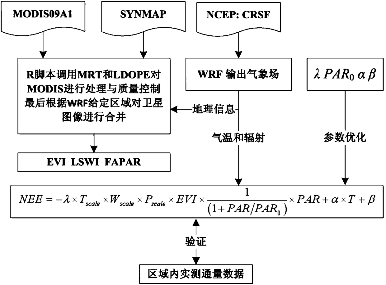
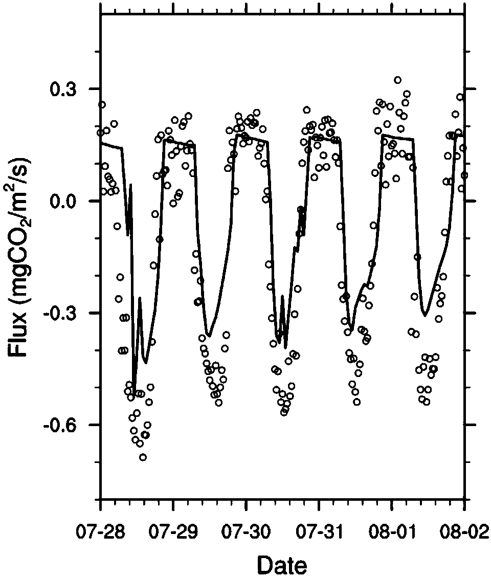
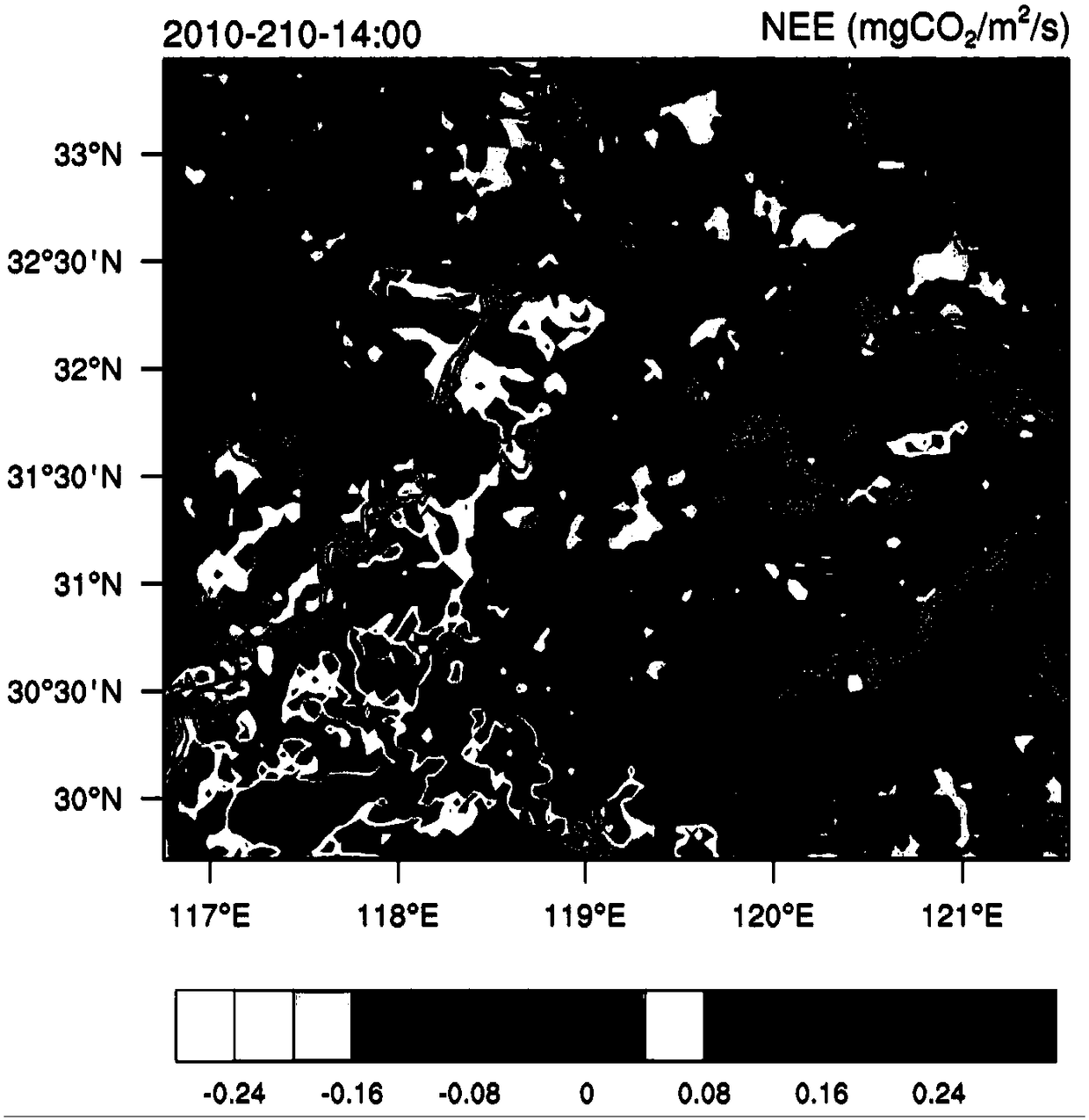
[0030] Example 1: Taking the Yangtze River Delta region as an example, high-resolution spatial information, air temperature and downward short-wave radiation are obtained through WRF simulation (such as triple nesting, the innermost layer is the Nanjing region, and the resolution is 4km x 4km).

[0031] Surface vegetation index (EVI, LSWI) is obtained from MODIS satellite retrieval data. We use the 8d average land surface albedo product MOD09A1 on the MODIS sensor carried by the NASA Terra satellite, and its spatial resolution is 500m. The data of blue (459-479nm), red (620-670nm), NIR (841-875nm) and SWIR (1628-1652nm) bands are used to calculate the vegetation index. The changes of EVI and LSWI due to 8d interval are relatively stable. The vegetation index can be calculated by the following formula:

[0032]

[0033]

[0034] where G=2.5, C 1 = 6, C 2=7.5, L=1. ρ stands for the surface albedo of the corresponding band, and the subscripts nir, red, blue and swir st...


PUM


Abstract

The invention discloses a regional carbon flux estimation method based on remote sensing data. A mesoscale meteorological model (WRF) is used to output results, to provide spatial information within atarget region range and required meteorological field data for a vegetation photosynthetic respiration model (VPRM). High-precision vegetation type data (SYNMAP with a resolution of 1 km) is extracted, to classify land use types in a target area; an enhanced vegetation index (EVI) and a land surface water index (LSWI) are obtained by inversion of medium-high-resolution remote sensing data (MODIS09A1); parameters such as the EVI and the LSWI are placed in a target area grid by a spatial difference method; for different regional characteristics, more than one year of historical observation datais used, and these parameters are optimized by using a light response equation (Michaelis-Menten); and finally, based on the data, the carbon flux calculation is performed on the target area using the VPRM model.

Description

technical field [0001] The invention relates to a method for estimating regional carbon flux based on remote sensing data, which uses high-resolution remote sensing data, high-precision vegetation type data and spatial geographic information to estimate the carbon flux in a given region. Background technique [0002] Since Monteith (1972) proposed the theory of linear correlation between net primary productivity (NPP, Net primary production) and plant-absorbed photosynthetically active radiation (FAPAR, The Fraction of Absorbed Photosynthetically Active Radiation), and with the promotion and application of remote sensing technology and products, Light Use Efficiency (LUE, Light Use Efficiency) models based on satellite remote sensing data have developed rapidly, such as CASA (Carnegie–Ames–Stanford Approach; Potter et al., 1993,1998), CFix (Carbon Fix; Veroustraete et al., 2002), CFlux (Carbon Flux; Turner et al., 2006; King et al., 2011), EC-LUE (EddyCovariance-Light Use Ef...

Claims


Application Information

Patent Timeline
Patent Type & Authority Applications(China)
IPC IPC(8): G06F17/50
CPCG06F30/20
Inventor 高嵩刁一伟刘洋毕晓甜张龙张量梁伟
Owner STATE GRID JIANGSU ELECTRIC POWER CO ELECTRIC POWER RES INST
Why Eureka
Try Eureka