Indoor and independent drone navigation method based on three-dimensional vision SLAM

A three-dimensional vision, autonomous navigation technology, applied in navigation, mapping and navigation, navigation calculation tools, etc., can solve the problems of unrecognized features, inaccurate pose estimation, feature loss, etc., to solve the problems of complexity and robustness , to avoid the effect of inability to locate and estimate the pose and pose accurately

Active Publication Date: 2018-07-20
江苏中科智能科学技术应用研究院
View PDF4 Cites 56 Cited by
  • Summary
  • Abstract
  • Description
  • Claims
  • Application Information

AI Technical Summary

Problems solved by technology

[0003] The sensors used to study SLAM are usually lasers and cameras. Laser positioning is more accurate, but the cost is high, and rich features cannot be recognized. Ordinary cameras are sensitive to l

Method used


Image

  • Indoor and independent drone navigation method based on three-dimensional vision SLAM
  • Indoor and independent drone navigation method based on three-dimensional vision SLAM
  • Indoor and independent drone navigation method based on three-dimensional vision SLAM

Examples


Embodiment Construction

[0024] The following description and drawings illustrate specific embodiments of the invention sufficiently to enable those skilled in the art to practice them. Other embodiments may incorporate structural, logical, electrical, process, and other changes. The examples merely represent possible variations. Individual components and functions are optional unless explicitly required, and the order of operations may vary. Portions and features of some embodiments may be included in or substituted for those of other embodiments. The scope of embodiments of the present invention includes the full scope of the claims, and all available equivalents of the claims.

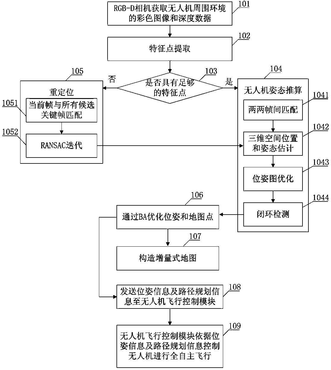
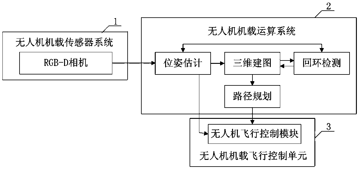
[0025] Such as figure 2 As shown, the SLAM system includes: UAV onboard sensor system 1 , UAV onboard computing system 2 and UAV onboard flight control unit 3 .

[0026] The RGB-D camera of the drone's onboard sensor system 1 is used to acquire color images and depth data of the drone's surrounding environment. The UA...


PUM


Abstract

The invention provides an indoor and independent drone navigation method based on three-dimensional vision SLAM. The indoor and independent drone navigation method comprises the steps that an RGB-D camera obtains a colored image and depth data of a drone surrounding environment; a drone operation system extracts characteristic points; the drone operation system judges whether enough characteristicpoints exist or not, if the quantity of the characteristic points is larger than 30, it shows that enough characteristic points exist, the drone attitude calculation process is conducted, or, relocating is conducted; a bundling optimizing method is used for global optimization; an incremental map is built. Drone attitude information is given with only one RGB-D camera, a three-dimensional surrounding environment is rebuilt, the complex process that a monocular camera solves depth information is avoided, and the problems of complexity and robustness of a matching algorithm in a binocular camera are solved; an iterative nearest-point method is combined with a reprojection error algorithm, so that drone attitude estimation is more accurate; a drone is located and navigated and independentlyflies indoors and in other unknown environments, and the problem that locating cannot be conducted when no GPS signal exists is solved.

Description

technical field [0001] The invention belongs to the technical field of indoor positioning and navigation of unmanned aerial vehicles, and in particular relates to an indoor autonomous navigation method for unmanned aerial vehicles based on three-dimensional vision SLAM. Background technique [0002] At present, the mainstream navigation system for UAV positioning is the integrated navigation system of GPS and inertial navigation system, but this method cannot be used indoors or in unknown environments where GPS cannot be used. The problem of SLAM research is that the robot performs its own positioning according to the position estimation and the map while moving in the unknown environment, and at the same time constructs an incremental map on the basis of its own positioning to realize the autonomous positioning and navigation of the robot. [0003] The sensors used to study SLAM are usually lasers and cameras. Laser positioning is more accurate, but the cost is high, and ri...

Claims


Application Information

Patent Timeline
IPC IPC(8): G01C21/20
CPCG01C21/206
Inventor 肖冉王伟杜浩徐朝文
Owner 江苏中科智能科学技术应用研究院
Why Eureka
Try Eureka