Unmanned aerial vehicle laser ranging device for monitoring construction storey height and applied to construction site and ranging method

A technology of laser rangefinder and laser rangefinder, which is applied in the field of building structures, can solve problems such as large data, potential safety hazards, and insufficient detection data accuracy

Pending Publication Date: 2018-07-20
JINLING INST OF TECH
View PDF0 Cites 5 Cited by
  • Summary
  • Abstract
  • Description
  • Claims
  • Application Information

AI Technical Summary

Problems solved by technology

Traditional construction site detection tools are too dependent on manpower, and the accuracy of detection data is not enough. Faced with various problems in line with the rapid and steady development of the modern construction industry, they can no longer meet the needs of modern construction. The construction industry detects intelligent tools on construction sites. currently blank
The problems caused by the current artificial construction site inspection tools are as follows: 1. The labor cost is high. Because the traditional construction site inspection tools require workers to go to the first site to measure and have a lot of data, it takes a long time for the workers to measure the numerous inspection data. 2. The risk factor is high, and some traditional high-rise inspection data also need to be measured by workers. The inspection of high-rise buildings has brought many safety hazards, which is not conducive to the safety of workers; 3. Affecting the building construction cycle, the traditional construction site inspection is to check the quality of the construction part after the construction has reached a certain stage, but through the workers to test, it will inevitably affect the normal operation of the next construction period and the progress of the project , at the same time, some workers participate in the inspection, which will inevitably affect the number of people in further construction

Method used


Image

  • Unmanned aerial vehicle laser ranging device for monitoring construction storey height and applied to construction site and ranging method
  • Unmanned aerial vehicle laser ranging device for monitoring construction storey height and applied to construction site and ranging method
  • Unmanned aerial vehicle laser ranging device for monitoring construction storey height and applied to construction site and ranging method

Examples


Embodiment Construction

[0021] Below in conjunction with accompanying drawing and specific embodiment the present invention is described in further detail:

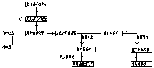
[0022] The invention provides an unmanned aerial vehicle laser ranging device and a ranging method for monitoring construction floor heights for construction sites. After adoption, it can replace traditional construction site detection tools. The use of four rotors and main rotors can ensure the stability of measurement, thereby greatly improving detection. Efficiency, reduced labor costs, and improved operational safety.

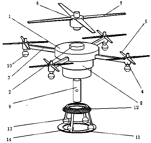
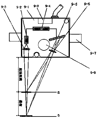
[0023] As an embodiment of the structure of the present invention, the present invention provides a UAV laser ranging device for monitoring construction floor heights on construction sites, including a UAV main body 1, a top motor mount 2, a side bracket 3, a side rotor motor 4, a side Rotor blade 5, main rotor motor 6, main rotor blade 7, range finder mounting seat 8, laser range finder 9, underframe 11, support frame 12 and...


PUM


Abstract

The invention relates to an unmanned aerial vehicle laser ranging device for monitoring construction storey height and applied to a construction site. The top of an unmanned aerial vehicle main body is provided with a top motor mounting seat; the top motor mounting seat is provided with a main rotor motor; the outer side of the rotating shaft of the main rotor motor is provided with main rotor blades; the outer side of the unmanned aerial vehicle main body is provided with four side brackets; the outer side ends of the side brackets are provided with side rotor motors; the rotating shafts of the side rotor motors face upwards; the outer sides of the rotating shafts of the side rotor motors are provided with side rotor blades; the bottom of the unmanned aerial vehicle main body is providedwith a range finder mounting seat; the upper part of a laser range finder is installed in the range finder mounting seat; a supporting frame is arranged under the unmanned aerial vehicle laser main body in a matched manner; a circular landing groove is formed at the center of the supporting frame; and the supporting frame is connected with a bottom frame through a supporting rod. With the unmannedaerial vehicle laser ranging device of the invention adopted, a traditional construction site detecting tool can be replaced; a four-rotor and one-main rotor structure is adopted, so that stationarity during measurement can be greatly improved, and therefore, detection efficiency can be greatly improved, and operation safety can be improved.

Description

technical field [0001] The invention relates to the field of building structures, in particular to an unmanned aerial vehicle laser ranging device and a ranging method for monitoring the height of a construction floor on a construction site. Background technique [0002] With the further development of my country's building informatization, the country proposes the construction of Industry 4.0 in 2020, and the country vigorously advocates the automation and periodicization of building construction. Traditional construction site detection tools are too dependent on manpower, and the accuracy of detection data is not enough. Faced with various problems in line with the rapid and steady development of the modern construction industry, they can no longer meet the needs of modern construction. The construction industry detects intelligent tools on construction sites. Currently blank. The problems caused by the current artificial construction site inspection tools are as follows:...

Claims


Application Information

Patent Timeline
Patent Type & Authority Applications(China)
IPC IPC(8): G01S17/08
CPCG01S17/08
Inventor 诸谧琳李俊儒
Owner JINLING INST OF TECH
Why Eureka
Try Eureka