A Dynamic Analysis Method of Soil Erosion in County Area-Small Watershed-Runoff Area

A technology for soil erosion and runoff cells, which is used in instruments, complex mathematical operations, design optimization/simulation, etc., to achieve the effect of meeting the needs of mutual correction

Active Publication Date: 2019-02-12
HOHAI UNIV
View PDF5 Cites 0 Cited by
  • Summary
  • Abstract
  • Description
  • Claims
  • Application Information

AI Technical Summary

Problems solved by technology

[0003] Purpose of the invention: In order to solve the problem that the existing technology cannot analyze the status quo of soil erosion at other scales through the analysis results of one scale, the present invention provides a dynamic analysis method of soil erosion in the county area-small watershed-runoff area

Method used


Image

  • A Dynamic Analysis Method of Soil Erosion in County Area-Small Watershed-Runoff Area

Examples


Embodiment Construction

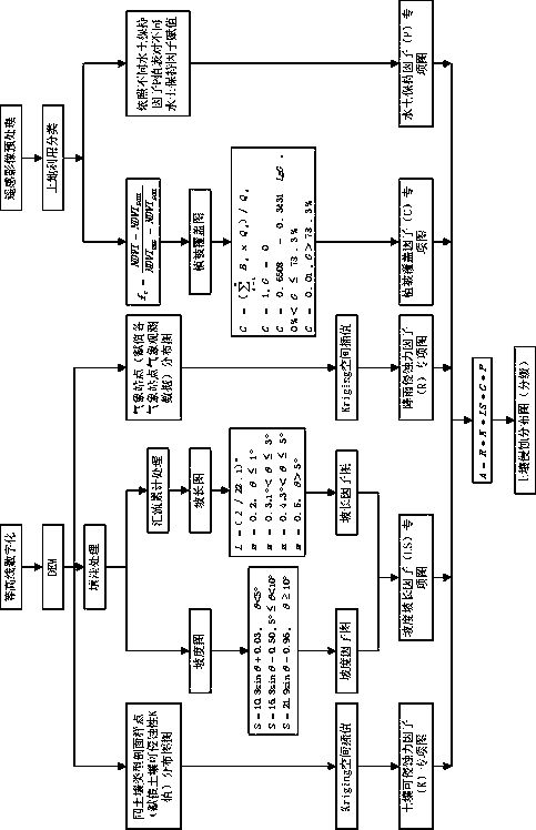
[0033] The present invention will be further described below in conjunction with the accompanying drawings and specific embodiments.

[0034] Such as figure 1 As shown, the soil erosion dynamic analysis method of county-small watershed-runoff plot includes the following steps:

[0035] Step 1: Based on the county topographic map and remote sensing images, make a soil erosion distribution map of the county remote sensing data, and analyze the county soil erosion modulus. The method of making the soil erosion distribution map of county-level remote sensing data is as follows:

[0036] (11) Provide county-level topographic maps and remote sensing images, use R2V software to digitize county-level topographic maps, use Arcgis software to define geographic coordinates for vectorized digital layers, and use the 3D Analyst module in Arcgis software to create DEM layers based on county-level topographic maps ;

[0037] According to the DEM layer, first use Arcgis software to make th...


PUM


Abstract

The invention discloses a soil erosion dynamic-analysis method of a county-small basin-runoff plot mode. A county soil erosion distribution graph is produced; actually measured small-basin and runoff-plot soil erosion moduli are used to respectively correct corresponding remote-sensing data; a county-small basin, county-runoff plot and small basin-runoff plot soil erosion modulus correction coefficient table is established; county and small-basin soil erosion moduli, soil erosion intensity levels and soil erosion potential-risk areas and runoff-plot soil erosion moduli and soil erosion intensity levels are obtained by the remote-sensing data according to the correction coefficient table; and the county and small-basin soil erosion moduli, soil erosion intensity levels and soil erosion potential-risk areas and the runoff-plot soil erosion moduli and soil erosion intensity levels are obtained by actually measured small-basin or runoff-plot data. According to the method, demand of large-scale digitization analysis and mutual correction of actually measured results can be satisfied, and manpower and material resources can also be saved.

Description

technical field [0001] The invention relates to environmental monitoring technology, in particular to a dynamic monitoring and analysis method for soil erosion proposed based on the relationship between monitoring data of different scales of soil erosion from monitoring points to small watersheds to counties. Background technique [0002] Soil erosion has always been a global environmental problem. The water and soil loss caused by soil erosion has seriously hindered China's economic development, destroyed China's land resources, and seriously affected China's ecological environment. In 2013, the results of the "First National Census of Water and Soil Conservation" (the base year of the census was 2011) were released, and the soil erosion area in China was 2.9491 million Km2 (excluding Hong Kong, Macao Special Administrative Region and Taiwan Province), accounting for China's land area 31.12% of that, but China's soil erosion situation is severe. The analysis methods of dif...

Claims


Application Information

Patent Timeline
Patent Type & Authority Patents(China)
IPC IPC(8): G06F17/50G06F17/18
CPCG06F17/18G06F30/20
Inventor 危闫事攀赵坚陶小虎刘东升张俊秀
Owner HOHAI UNIV
Why Eureka
Try Eureka