Polarized light SLAM method based on extended Kalman filter

A technology that extends Kalman and polarized light, and is applied in complex mathematical operations, navigation calculation tools, etc. It can solve the problems of difficulty in determining the drone's own position, inaccurate composition, poor environmental adaptability, etc., to achieve enhanced adaptability and high precision. , the effect of improving the accuracy

Active Publication Date: 2018-08-10
NORTH CHINA UNIVERSITY OF TECHNOLOGY +1
View PDF5 Cites 13 Cited by
  • Summary
  • Abstract
  • Description
  • Claims
  • Application Information

AI Technical Summary

Problems solved by technology

[0006] The main problem to be solved by the present invention is: how to apply the polarization information to the UAV SLAM to solve the problems in the simultaneous positioning and composition of the UAV, such as difficulty in determining its own position, poor environmental adaptability, and inaccurate composition.

Method used


Image

  • Polarized light SLAM method based on extended Kalman filter
  • Polarized light SLAM method based on extended Kalman filter
  • Polarized light SLAM method based on extended Kalman filter

Examples


Embodiment Construction

[0056] The present invention will be further described below in conjunction with the accompanying drawings and specific embodiments.

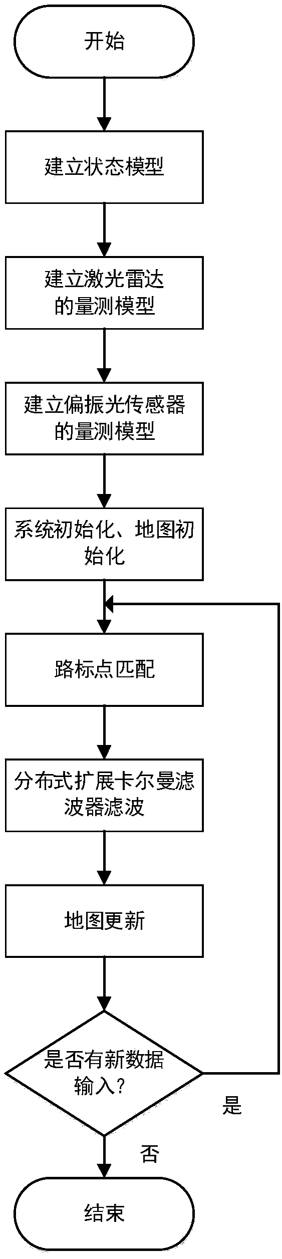
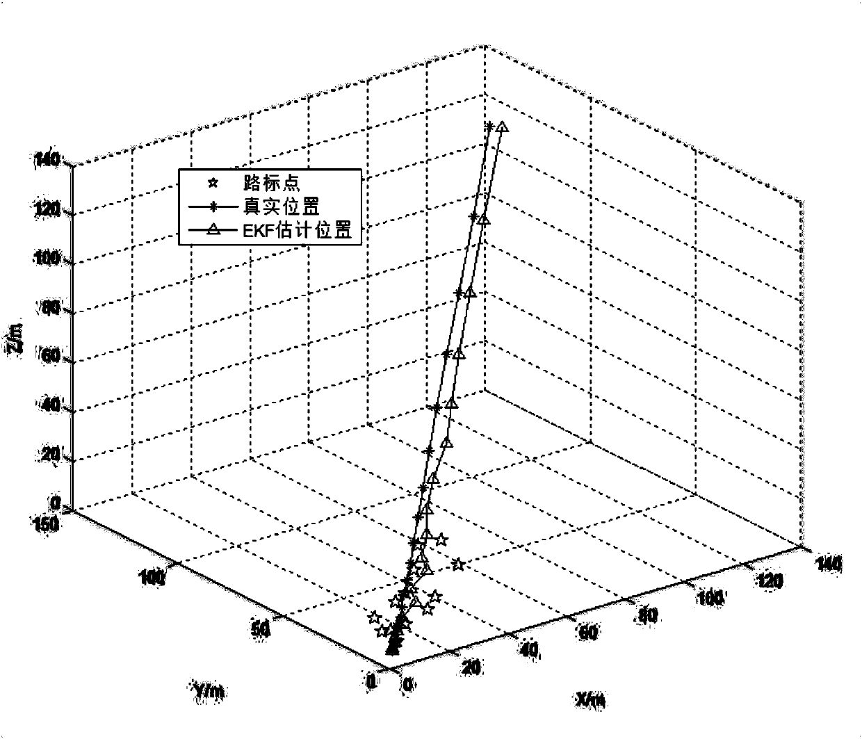
[0057] Such as figure 1 Shown, a kind of polarized light SLAM method based on extended Kalman filtering of the present invention comprises the following steps:

[0058] (1) Select the attitude, speed, position and landmarks of the UAV as the system state, and establish the dynamic model of the UAV;

[0059] Described step (1) selects the attitude, speed, position and landmark point of unmanned aerial vehicle as system state, sets up the dynamics model of unmanned aerial vehicle; Take the unmanned aerial vehicle starting position as the world coordinate system of origin, i.e. w system, Take the north direction as the positive direction of the x-axis of the world coordinate system, take the due west direction as the positive direction of the y-axis of the world coordinate system, and determine the positive direction of the z-axis of the world co...


PUM


Abstract

The invention discloses a polarized light SLAM method based on extended Kalman filter, and belongs to the field of autonomous navigation of unmanned aerial vehicles. The method realizes the determination of the position of an unmanned aerial vehicle and the construction of a surrounding environment map through an EKF algorithm that is distributed extended Karl filter by establishing the state model of the unmanned aerial vehicle and a measurement model based on a laser radar sensor and a polarized light sensor, and the characteristics of matching, complementation and no outside interference ofpolarized light information and laser radar information are used to improve the accuracy of simultaneous positioning and composing of the unmanned aerial vehicle.

Description

technical field [0001] The present invention relates to UAV Simultaneous Positioning and Mapping (SLAM), which belongs to the category of UAV autonomous navigation, and specifically relates to a polarized light SLAM method based on extended Kalman filtering, how to determine its own position and perceive the external environment for UAVs The problem is that the SLAM system aims to complete the positioning of the UAV and the drawing of the surrounding environment through the UAV system model and the corresponding filtering method. Background technique [0002] SLAM is the abbreviation of Simultaneous Localization and Mapping, which means "simultaneous positioning and mapping". It refers to the process in which a moving object calculates its own position and builds an environmental map based on the information of the sensor. At present, SLAM technology has been used in drones, unmanned driving, robots, AR, smart home and other fields. [0003] SLAM research focuses on using ...

Claims


Application Information

Patent Timeline
Patent Type & Authority Applications(China)
IPC IPC(8): G01C21/20G06F17/16
CPCG01C21/20G06F17/16
Inventor 杜涛白鹏飞郭雷王华锋刘万泉王月海
Owner NORTH CHINA UNIVERSITY OF TECHNOLOGY
Why Eureka
Try Eureka