Sub-watershed division method of large-scale complicated topography area distributed hydrologic model

A distributed hydrology and complex terrain technology, applied in special data processing applications, instruments, electrical digital data processing, etc., to achieve the effect of taking into account accuracy and efficiency requirements and good applicability

Inactive Publication Date: 2018-08-14
CHINA INST OF WATER RESOURCES & HYDROPOWER RES
View PDF5 Cites 23 Cited by
  • Summary
  • Abstract
  • Description
  • Claims
  • Application Information

AI Technical Summary

Problems solved by technology

[0003] The technical problem to be solved by the present invention is to overcome the defects existing in the existing sub-basin division technology, based on the topological coding rules of DEM river network branches and bra...

Method used


Image

  • Sub-watershed division method of large-scale complicated topography area distributed hydrologic model
  • Sub-watershed division method of large-scale complicated topography area distributed hydrologic model
  • Sub-watershed division method of large-scale complicated topography area distributed hydrologic model

Examples


Embodiment Construction

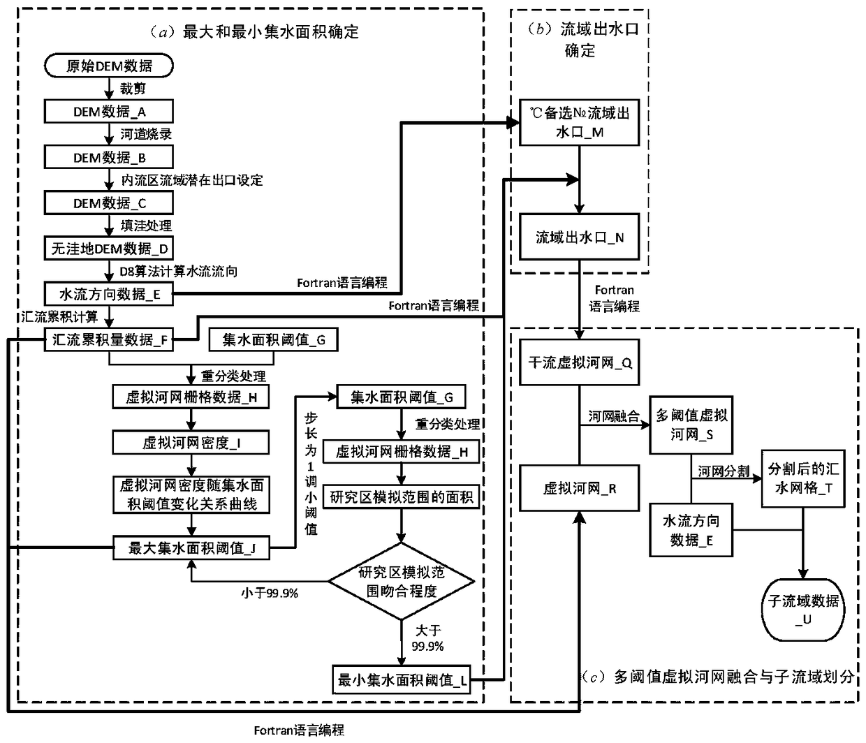
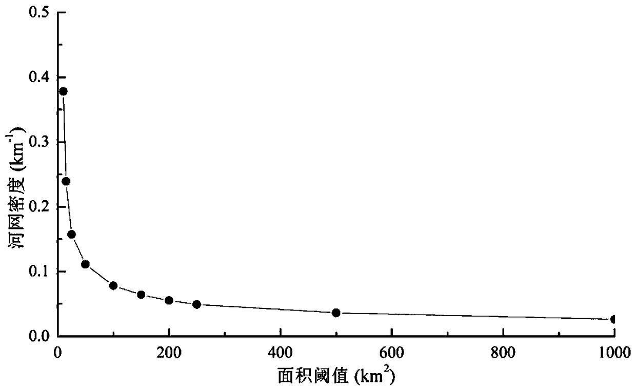
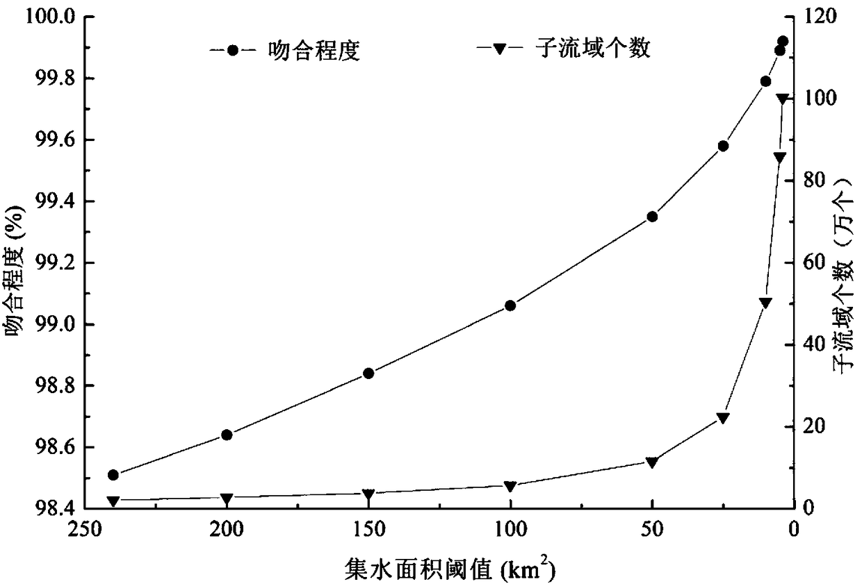
[0039] Below in conjunction with accompanying drawing and specific embodiment, the present invention is described in further detail:

[0040] my country is a typical large-scale and complex topographical area, with the following salient features: 1) Large area, spanning about 50 latitudes from north to south, and 61 longitudes from east to west; 2) Numerous rivers and lakes, internal and external water systems Coexistence; 3) The coastline is long, and the topography of the offshore area fluctuates drastically. Taking my country as an example, it is quite representative.

[0041]The DEM data used is the 90m×90m SRTM raster data jointly measured and produced by the National Space Administration (NASA) and the National Mapping Agency (NIMA) of the Ministry of National Defense. It is resampled to the 1km×1km DEM raster data as this example Expanded base data. At the same time, the national 1:4 million measured water system and nationwide areal vector map data are used to correct...


PUM


Abstract

The invention discloses a sub-watershed division method of a large-scale complicated topography area distributed hydrologic model. The method includes the steps: maximum and minimum water-collecting area threshold value determination; watershed water outlet determination; multi-threshold virtual river network fusion; sub-watershed division. According to the method, watershed water outlets can be automatically, efficiently and rapidly identified, the method primarily solves the problem of extraction distortion of river networks in an internal flow area, and topological relationships among divided sub-watersheds can be accurately described, the number of the sub-watersheds is effectively controlled when research area ranges are accurately fitted, and accuracy and efficiency requirements of model simulation are comprehensively considered. The method has good applicability on the sub-watershed division in large-scale complicated topography area, and relevant results can provide strong support for construction of the macro-scale area distributed hydrologic models.

Description

technical field [0001] The invention relates to the technical field of water conservancy engineering, in particular to a sub-watershed division method, in particular to a sub-watershed division method for a distributed hydrological model in a large-scale complex terrain area. Background technique [0002] According to the geographical characteristics of the research object, distributed hydrological simulation can be divided into two categories: one is distributed hydrological simulation for complete watersheds, and the other is regional distributed hydrological simulation for administrative regions or artificially demarcated areas. When the spatial scale of the research object is large, in order to take into account the accuracy and efficiency of the simulation, GIS is generally used as the platform, and the virtual river network is extracted based on the grid DEM, and the research area is divided into a certain number of sub-basins, and the sub-basin is used as the basic sim...

Claims


Application Information

Patent Timeline
IPC IPC(8): G06F17/50
CPCG06F30/20
Inventor 杜军凯刘欢刘佳嘉贾仰文牛存稳仇亚琴
Owner CHINA INST OF WATER RESOURCES & HYDROPOWER RES
Why Eureka
Try Eureka