Combined navigation system based on OMAP-L138 processor

An integrated navigation system and processor technology, applied in the field of integrated navigation system based on OMAP-L138 processor, can solve the problems of difficult to achieve self-alignment, lack of initial state information, difficult to navigate for a long time, etc., to improve navigation accuracy and reliability effects

Inactive Publication Date: 2018-08-17
NANJING UNIV OF POSTS & TELECOMM
View PDF4 Cites 0 Cited by
  • Summary
  • Abstract
  • Description
  • Claims
  • Application Information

AI Technical Summary

Problems solved by technology

Its disadvantage is that the error will gradually accumulate over time, it is difficult to use it alone for long-term navigation, and it lacks initial state information, making it difficult to achieve self-alignment

Method used


Image

  • Combined navigation system based on OMAP-L138 processor
  • Combined navigation system based on OMAP-L138 processor
  • Combined navigation system based on OMAP-L138 processor

Examples


Embodiment Construction

[0036] The present invention will be further described below in conjunction with the accompanying drawings.

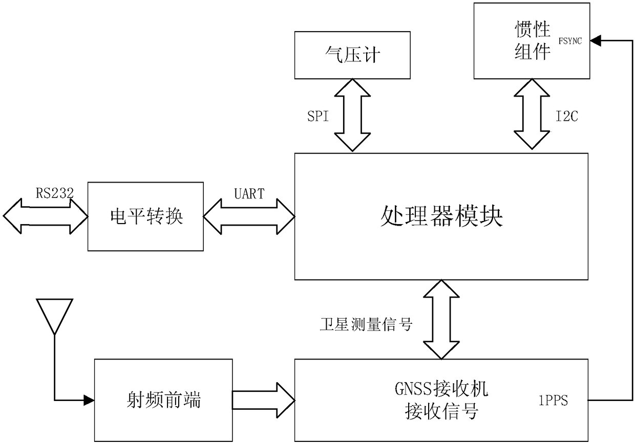
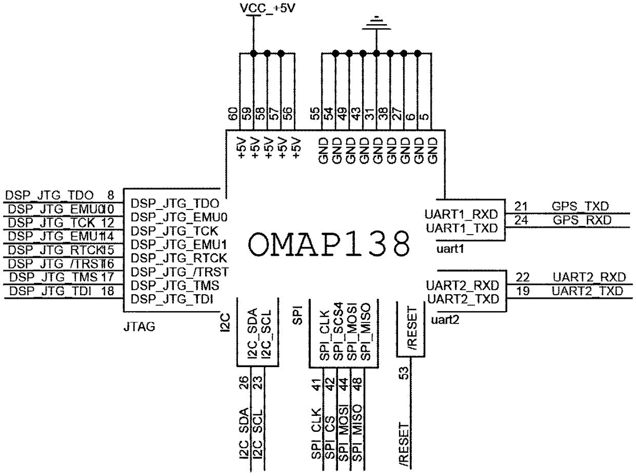
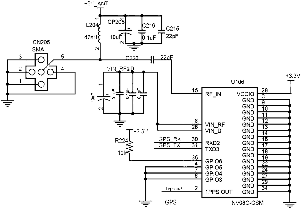
[0037] An integrated navigation system based on an OMAP-L138 processor includes a processor module, a satellite navigation data receiving module, a navigation auxiliary module, a communication module, and a power supply module.

[0038] The data received by the processor module comes from the satellite navigation data receiving module and the inertial component MPU9150 and barometer MS5611 in the auxiliary module, such as figure 1 shown. Among them: 1) The satellite navigation data module receives satellite signals through the antenna of the RF front end, and sends the received signals to the embedded computer through the connection between UART2 of the receiver and the controller with the BINR data exchange protocol; 2) the auxiliary module I 2 The C communication method sends the read information to the processor, and the barometer MS5611 uses the SPI communication...


PUM


Abstract

The invention discloses a combined navigation system based on an OMAP-L138 processor. The system comprises a processor module, a satellite navigation signal receiver module, a navigation auxiliary module, a communication module and a power supply module. The processor module is the master control module of the system. The satellite navigation signal receiver module comprises an NV08C-CSM receiverand an external antenna radio frequency circuit. The navigation auxiliary module comprises an inertial component MPU9150 and a barometer MS5611. The communication module is an UART to RS232 module. The power supply module provides +5V and +3.3V levels for a platform. In the invention, through using ARM+DSP combination, the ARM is mainly used to control the whole system and carry out data acquisition, including the satellite navigation data of the NV08C-CSM receiver and the data of the inertial component MPU9150 and the barometer MS5611. And the DSP is mainly used to calculate a navigation algorithm with high complexity. The system can satisfy requirements to a calculation capability, data precision, synchronization, real-time operation, data sharing and the like in combined navigation information processing.

Description

technical field [0001] The invention belongs to the technical field of integrated navigation systems, and in particular relates to an integrated navigation system based on an OMAP-L138 processor. Background technique [0002] The satellite navigation system has developed into an important facility foundation for human activities and social development. At present, the Global Navigation Satellite System (GNSS, Global Navigation Satellite System) includes all satellite navigation systems, including the GPS of the United States, GLONASS of Russia, GALILEO of the European Union, and BDS of China. Continuous 3D position, 3D velocity and time information. The basic principle of the satellite navigation system is to calculate the distance between the sending and receiving endpoints by measuring the radio propagation time, combined with the propagation speed, and then calculate the location information of the receiving end according to the previously determined location of the send...

Claims


Application Information

Patent Timeline
IPC IPC(8): G01S19/49
CPCG01S19/49
Inventor 王冬生陆永杰
Owner NANJING UNIV OF POSTS & TELECOMM
Why Eureka
Try Eureka