Multi-line laser radar ground point separation method, device, vehicle

A multi-line laser and radar ground technology, used in measurement devices, image analysis, radio wave measurement systems, etc., can solve the problems of inaccurate separation of obstacle point clouds and ground point clouds, low real-time performance, and long time consumption.

Active Publication Date: 2018-08-21
BEIJING ZHIXINGZHE TECH CO LTD
View PDF4 Cites 29 Cited by
  • Summary
  • Abstract
  • Description
  • Claims
  • Application Information

AI Technical Summary

Problems solved by technology

The ground point cloud separation technology in the existing technology still has many shortcomings such as inac

Method used


Image

  • Multi-line laser radar ground point separation method, device, vehicle
  • Multi-line laser radar ground point separation method, device, vehicle
  • Multi-line laser radar ground point separation method, device, vehicle

Examples


Example Embodiment

[0021] In the drawings, the same or similar reference signs are used to indicate the same or similar elements or elements with the same or similar functions. The embodiments of the present invention will be described in detail below in conjunction with the drawings.

[0022] The multi-line lidar ground point separation method provided in this embodiment includes the following steps:

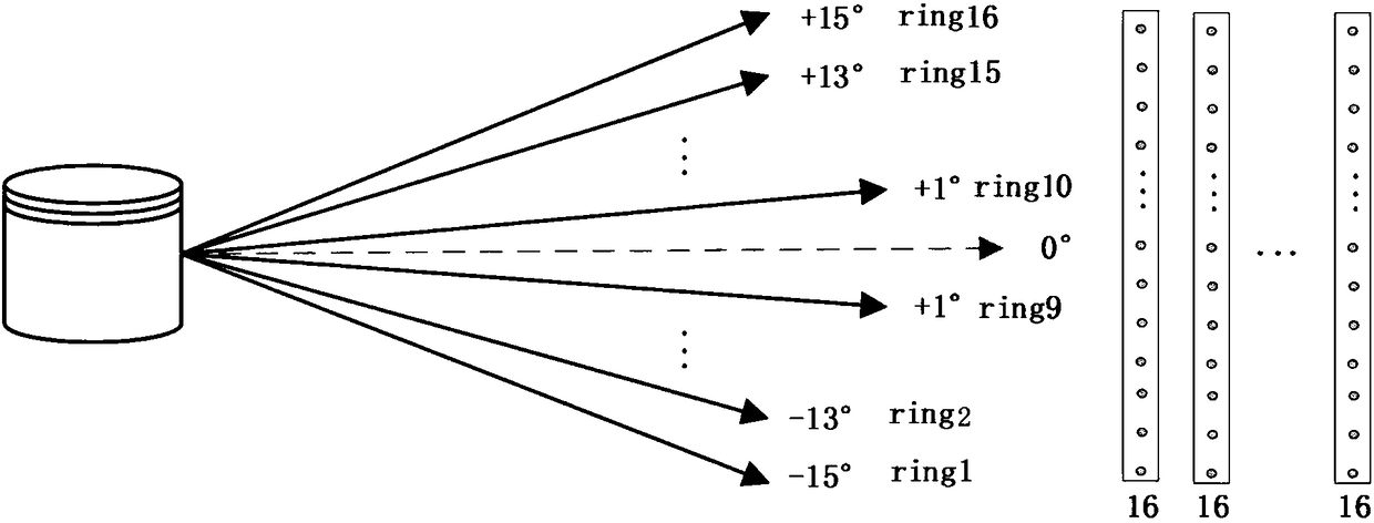
[0023] Step 100: Scan the detection area in a horizontally rotating manner through the laser lines emitted by the multi-line lidar to obtain point cloud data collected by the multi-line lidar. The following describes the implementation method of this step through 16-line lidar.

[0024] Such as figure 1 As shown, the straight line with arrows in the figure shows the laser line emitted by the 16-line lidar. In the lidar coordinate system, each laser head emits and undergoes internal coordinate conversion to the same origin coordinate system, that is, the lidar coordinate system. The horizontal plane i...


PUM


Abstract

The invention discloses a multi-line laser radar ground point separation method, a multi-line laser radar ground point separation device, and a vehicle. The method includes the following steps that: 100, a detection area is scanned in a horizontal rotation manner with laser lines emitted by a multi-line laser radar, so that point cloud data collected by the multi-line laser radar can be obtained;step 200, a three-dimensional grid chart is generated according to the point cloud data; step 300, the attributes of each node of the grid chart are calculated; and step 400, each node in the grid chart is traversed, whether a node is a ground point is judged, if the node is a ground point, the node is deleted, if the node is not a ground point, the node is reserved, and the reserved node is an obstacle point cloud. According to the multi-line laser radar ground point separation method of the invention, the three-dimensional grid chart is adopted; whether each point cloud scanned by the multi-line laser radar is a ground point is judged by means of the calculation of the attributes of the point cloud and the attribute spread of adjacent points; a foreground and a background can be accurately separated from each other; and thus, a smooth road surface can be well processed, the method can be applicable to various road conditions, and time consumption can always be controlled at about 50ms, and the method has high real-time performance.

Description

Technical field [0001] The invention relates to the technical field of ground point cloud separation, in particular to a method and device for ground point separation of a multi-line lidar, and a vehicle. Background technique [0002] Obstacle detection based on multi-line lidar is one of the most critical technologies in intelligent driving systems. Its accuracy and real-time performance are important indicators to measure intelligent driving systems. For obstacle detection of multi-line lidar, in order to be able to accurately identify the obstacle, it is necessary to accurately separate the obstacle (that is, foreground) point cloud and ground (background) point cloud. The ground point cloud separation technology in the prior art still has many shortcomings, such as inaccurate separation of obstacle point clouds and ground point clouds, long time-consuming, and low real-time performance. [0003] Therefore, it is desired to have a technical solution to overcome or at least alle...

Claims


Application Information

Patent Timeline
IPC IPC(8): G01S17/93G06K9/00G06T7/00G06T7/521G06T17/20
CPCG06T7/0002G06T7/521G06T17/20G06T2207/30261G06T2207/10028G06T2207/10044G01S17/931G06V20/58
Inventor 张德兆王肖李晓飞李慧慧陈东
Owner BEIJING ZHIXINGZHE TECH CO LTD
Why Eureka
Try Eureka