
Intelligent Beidou RTK device based on TypeC+OTG and positioning method thereof

A positioning method and equipment technology, applied in satellite radio beacon positioning systems, instruments, measurement devices, etc., can solve the problems of time-consuming and laborious search for geological targets, difficulties in data carrying and management, and narrow survey field of view, and improve field operations. Efficiency, easy portability of equipment, and the effect of many user groups

Active Publication Date: 2018-09-07
湖北智途北斗空间信息技术有限公司
View PDF11 Cites 6 Cited by
  • Summary
  • Abstract
  • Description
  • Claims
  • Application Information

AI Technical Summary

Problems solved by technology

[0002] Traditional field geological work methods are completed with paper media plus manual recording to paper media, which makes it difficult to carry and manage background data, text records, sketch maps, catalog maps, geological photos, and sampling information, making the investigation field narrow and geological. Goal finding is time-consuming and labor-intensive
At the same time, when high-precision position coordinates are required (such as drilling), a surveyor must work together
Traditional surveyors need to set up two professional GPS receivers, one as a reference station to provide a differential source, and one as a rover stakeout point, this mode is not only expensive but also time-consuming and laborious

Method used


Image

  • Intelligent Beidou RTK device based on TypeC+OTG and positioning method thereof
  • Intelligent Beidou RTK device based on TypeC+OTG and positioning method thereof

Examples


Embodiment Construction

[0025] In order to make the purpose, technical solution and advantages of the present invention clearer, the embodiments of the present invention will be further described below in conjunction with the accompanying drawings.

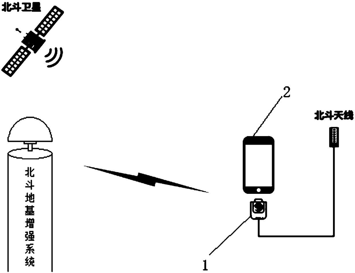
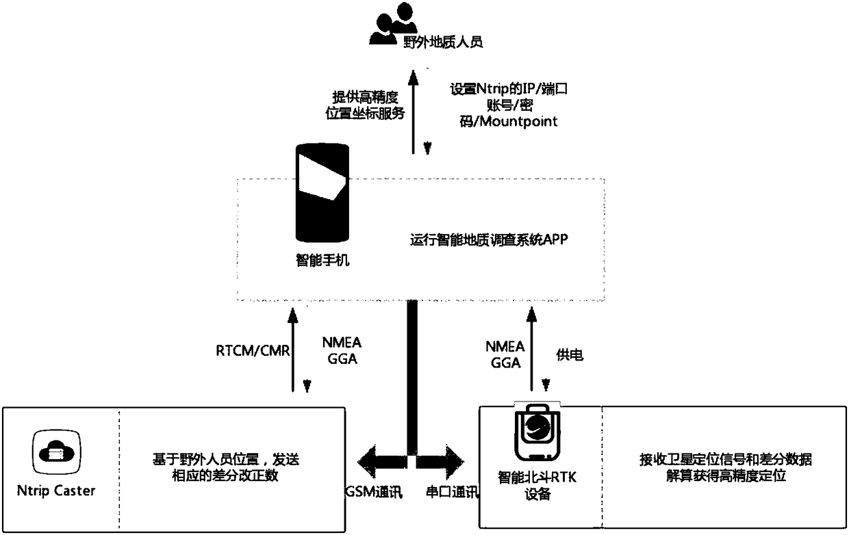
[0026] Please refer to figure 1 , the embodiment of the present invention provides an intelligent Beidou RTK device based on TypeC+OTG, and inserts the RTK device 1 receiving Beidou satellite and its ground-based augmentation system into the mobile phone 2 by using the TypeC+OTG technology.

[0027] The RTK device 1 has a small appearance, like the size of a USB flash drive. It has a Type-C socket and an external antenna interface. It has a built-in high-precision Beidou chip and an RTK algorithm module, and is capable of autonomous positioning and external differential data-assisted positioning. It can be powered by mobile phone 2, and the external indicator light can reflect the positioning mode through different colors: 1) Yellow light: single point p...


PUM


Abstract

The invention discloses an intelligent Beidou RTK device based on the TypeC+OTG. The RTK device for receiving a Beidou satellite and a foundation enhancing system thereof is plugged in a cell phone, an intelligent geological survey system is installed in the cell phone, and high-precision positioning information can be obtained through the intelligent geological survey system in the cell phone. The invention further discloses a positioning method of the intelligent Beidou RTK device based on the TypeC+OTG. A geologist can rapidly obtain high-precision positioning, labor is saved, meanwhile themeasured section and crack collecting can be conducted, and the geological field work efficiency is greatly improved.

Description

technical field [0001] The invention relates to the field of intelligent geological surveying and mapping equipment, in particular to an intelligent Beidou RTK equipment based on TypeC+OTG and a positioning method thereof. Background technique [0002] Traditional field geological work methods are completed with paper media plus manual recording to paper media, which makes it difficult to carry and manage background data, text records, sketch maps, catalog maps, geological photos, and sampling information, making the investigation field narrow and geological. Goal finding is time-consuming and laborious. At the same time, when high-precision position coordinates are required (such as drilling), a surveyor must work together. Traditional surveyors need to set up two professional GPS receivers, one for the reference station to provide differential sources, and one for the rover to stake out points. This mode is not only expensive but also time-consuming and laborious. Nowada...

Claims


Application Information

Patent Timeline
IPC IPC(8): G01S19/41G01S19/43
CPCG01S19/41G01S19/43
Inventor 肖泽云
Owner 湖北智途北斗空间信息技术有限公司
Learn More