Method for estimating annual sea ice thickness by using optical remote sensing images

An optical remote sensing image and annual technology, applied in the field of remote sensing, can solve the problems of insufficient practicality of the model, lack of stability, insufficient quantification of the model, etc., and achieve the effect of reducing sea ice estimation error and improving accuracy

Active Publication Date: 2018-09-11
NATIONAL MARINE ENVIRONMENTAL MONITORING CENTRE
View PDF9 Cites 5 Cited by
  • Summary
  • Abstract
  • Description
  • Claims
  • Application Information

AI Technical Summary

Problems solved by technology

[0004] However, these models using optical, thermal infrared and microwave remote sensing images as data sources for estimating the thickness of sea ice in the Bohai Sea are slightly insufficient in quantification, biased and empirical.
The parameters in many models need to be determined empirically, which does not have wide applicability; or the parameters in the model change with time and space, and are not stable; or the parameters in the model are determined to be inoperable, making the model not practical enough

Method used


Image

  • Method for estimating annual sea ice thickness by using optical remote sensing images
  • Method for estimating annual sea ice thickness by using optical remote sensing images
  • Method for estimating annual sea ice thickness by using optical remote sensing images

Examples


Embodiment

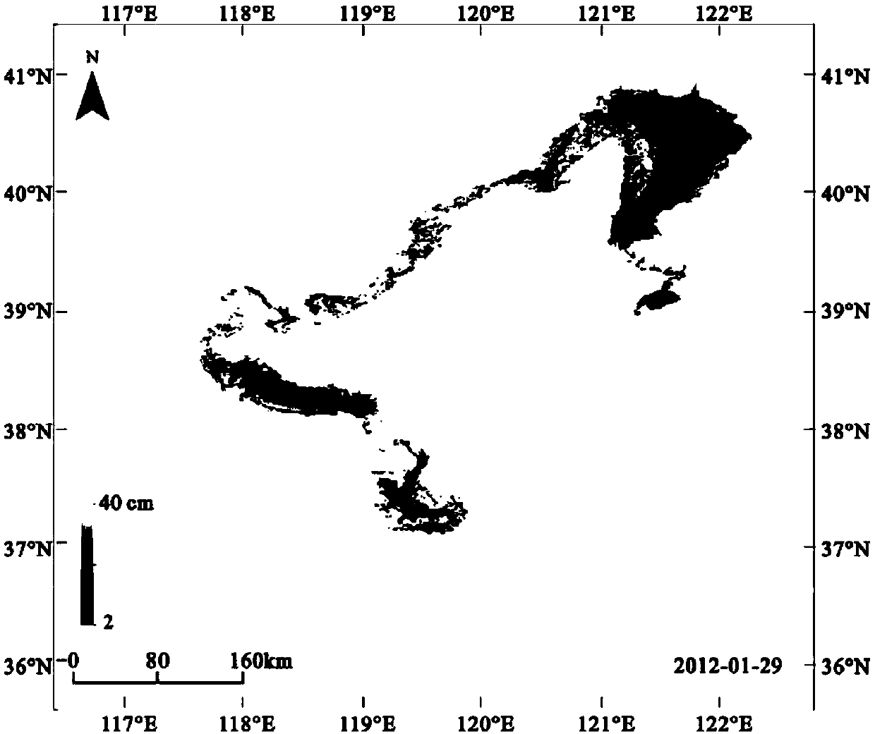
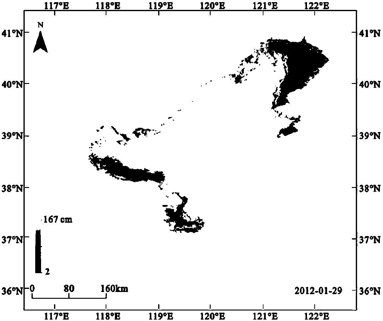
[0049] In order to verify the effect of the present invention, the Bohai Sea of ​​China is selected as the target sea area. The implementation method of this embodiment is as described above, and the Bohai sea ice thickness estimation is implemented according to the following steps:

[0050] 1) Collect images of bands 1, 2, 4, 5, and 7 from the Moderate-resolution imaging spectroradiometer (MODIS) in the Bohai Sea. The imaging date is January 29, 2010, and the imaging time is 11:00 Beijing time . The corresponding center wavelengths are 645nm, 859nm, 555nm, 1240nm and 2130nm respectively. Select the clear sky in the field to use ASD to measure the reflection spectrum data and corresponding ice thickness data of Bohai sea ice and seawater in the range of 400-2500nm. The output spectrum sampling interval of the ASD spectrometer is 1nm. The total amount of data is 37, and the collection of calibration data is completed;

[0051] 2) Calibrate the parameters in the annual sea ic...


PUM


Abstract

The invention discloses a method for estimating the annual sea ice thickness by using optical remote sensing images, which can quickly and accurately estimate the annual sea ice thickness in a wide range and obtain the sea ice thickness distribution map. The method for estimating the annual sea ice thickness by using the optical remote sensing images includes the following steps: (1) collecting the required target sea area optical remote sensing data and ground calibration data; (2) calibrating parameters in an annual sea ice thickness estimation model; (3) preprocessing the optical remote sensing images to obtain a required reflectivity image; (4) extracting a sea ice range and obtaining a sea ice mask; and (5) calculating the sea ice thickness by using the calibrated annual sea ice thickness estimation model according to the sea ice mask, and obtaining the sea ice thickness distribution map. The method for estimating the annual sea ice thickness by using the optical remote sensing images can greatly improve the estimation efficiency of the annual sea ice, and realize the large-scale, fast and accurate acquisition of the sea ice thickness distribution map in the target sea area.

Description

technical field [0001] The invention relates to the field of remote sensing, in particular to a method for estimating annual sea ice thickness from optical remote sensing images. Background technique [0002] High-latitude coastal waters are areas where annual sea ice frequently occurs (such as the Bohai Sea and the Baltic Sea). Although the thickness of annual sea ice is mostly a few centimeters to tens of centimeters, the annual winter sea ice poses a threat to maritime traffic safety, marine farming, and offshore oil platforms. serious harm. On the other hand, the sea ice desalination research being carried out by Chinese researchers can convert sea ice (brackish water) into fresh water through desalination treatment, providing a new fresh water resource for socioeconomic development in coastal areas. Therefore, regardless of whether it is considered from the perspective of disasters or from the perspective of resources to consider turning sea ice into wealth, timely gra...

Claims


Application Information

Patent Timeline
IPC IPC(8): G01B11/06G06T7/00
CPCG01B11/0625G06T7/0002G06T2207/10032G06T2207/30184
Inventor 袁帅刘成玉刘雪琴
Owner NATIONAL MARINE ENVIRONMENTAL MONITORING CENTRE
Why Eureka
Try Eureka