
Quantitative evaluation method for urban heat island effect

A technology for quantitative evaluation of urban heat island effect, applied in the field of quantitative evaluation of urban heat island effect, and can solve problems such as lack of quantitative models

Inactive Publication Date: 2018-09-18
WUHAN UNIV OF TECH
View PDF4 Cites 9 Cited by
  • Summary
  • Abstract
  • Description
  • Claims
  • Application Information

AI Technical Summary

Problems solved by technology

[0004] Based on the research status at home and abroad, the research on the coupling relationship between urban heat island and land use type is mainly manifested in the qualitative analysis and simulation of the heat island effect by using different technical methods, but there is a lack of more quantitative models to better characterize the urban heat island effect. the numerical relationship between them, so new methods and models need to be introduced

Method used


Image

  • Quantitative evaluation method for urban heat island effect
  • Quantitative evaluation method for urban heat island effect
  • Quantitative evaluation method for urban heat island effect

Examples


Embodiment Construction

[0017] Below in conjunction with accompanying drawing and specific embodiment the present invention is described in further detail:

[0018] A kind of quantitative evaluation method method of urban heat island effect designed by the present invention, it comprises the steps:

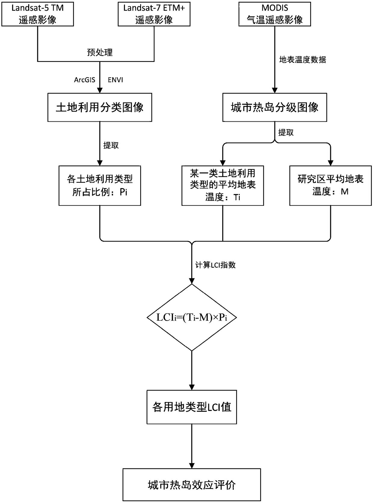
[0019] Step 1: Obtain the original remote sensing image data of the city in the study area, and use the computer (ArcGIS and ENVI software) to perform atmospheric correction, projection transformation, image registration and cropping, and image preprocessing of geometric correction on the acquired original remote sensing image of the city in the study area , and based on the support vector machine classification method in supervised classification, the remote sensing images after image preprocessing are divided into five land use types: water body, construction land, forest land, cultivated land and unused land, and the urban land use classification map of the study area is obtained, and Combining land u...


PUM


Abstract

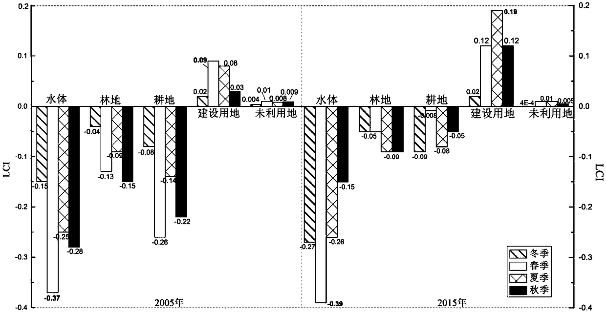
The invention discloses a quantitative evaluation method for an urban heat island effect. The method comprises the following steps of 1, performing data acquisition and preprocessing; 2, calculating an urban heat island intensity and grading; 3, calculating a land utilization contribution index LCI; and 4, coupling urban heat island effect evaluations of the land utilization type based on an LCI index model. The quantitative evaluation method is used for more accurately quantifying the relation between different land utilization types of the city and the urban heat island effect, and the influence of land utilization layout change to the heat island effect. The change of an urban underlying surface is used as a most important factor which affects the urban heat island effect. According tothe quantitative evaluation method, the relation between the land utilization type and the urban heat island effect is quantitatively evaluated, and a scientific guidance basis is laid for reasonableutilization and configuration of the urban land resource.

Description

technical field [0001] The invention relates to the field of earth science and technology, in particular to a quantitative evaluation method for urban heat island effect. Background technique [0002] Since the mid-20th century, urbanization has become one of the most important human activities. The influx of rural population into cities and the consequent conversion of urban green spaces to impervious surfaces often leads to an ecological imbalance between urban and rural areas. With the development of urbanization, the thermal properties of the underlying surface of the city have changed, which is reflected in the high temperature zone in the urban center and the low temperature zone in the suburbs near the urban area, that is, the urban heat island effect (Urban Heat Island). In the related research of urban heat island effect, the relationship between urban heat island and land use type has attracted extensive attention of many scholars and has become an important resea...

Claims


Application Information

Patent Timeline
Patent Type & Authority Applications(China)
IPC IPC(8): G06K9/00G06Q10/06
CPCG06Q10/0639G06V20/13Y02A30/60
Inventor 黄解军黄秋萍赵力学梁友嘉詹云军
Owner WUHAN UNIV OF TECH
Learn More