Non-uniform high-precision surface grid water flow and water quality simulation and visualization method and system

A high-precision, curved surface model technology, applied in general water supply conservation, climate change adaptation, design optimization/simulation, etc., can solve problems such as poor real-time performance, insufficient immersion, and inability to balance model calculation efficiency and accuracy, and achieve improved Simulation accuracy, effects of improving simulation accuracy and efficiency

Active Publication Date: 2021-07-20
CHINA INST OF WATER RESOURCES & HYDROPOWER RES
View PDF0 Cites 0 Cited by
  • Summary
  • Abstract
  • Description
  • Claims
  • Application Information

AI Technical Summary

Problems solved by technology

In actual engineering, the calculation domain often includes narrow river channel areas and dikes with significant terrain changes, relatively flat river channel beaches and large floodplain areas. Using unified grid modeling will not be able to balance the calculation efficiency and accuracy of the model
At present, the processing of the underlying surface in complex terrain areas is rarely involved in the current water flow and water quality simulation, and the existing pre-processing software is usually used for modeling. The modeling method used by these software is mainly based on the inverse distance weighting method, and the modeling accuracy cannot be guaranteed.
Most water flow and water quality simulation calculations use visualization after the calculation is completed, and most of them are two-dimensional visualization, which lacks real-time intervention methods for the calculation process and visualization lacks the real environment, making it impossible to perform accurate spatial positioning, lack of immersion, and real-time performance. Not strong

Method used


Image

  • Non-uniform high-precision surface grid water flow and water quality simulation and visualization method and system
  • Non-uniform high-precision surface grid water flow and water quality simulation and visualization method and system
  • Non-uniform high-precision surface grid water flow and water quality simulation and visualization method and system

Examples


Embodiment 1

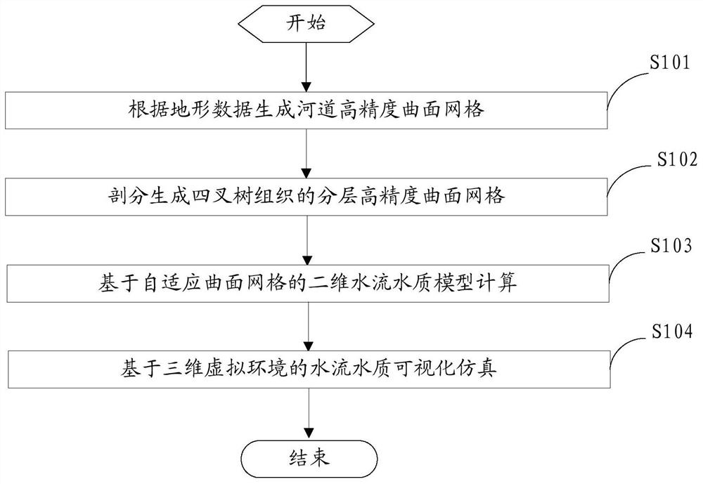
[0044] figure 1 It is a flow chart of the steps of the method for simulating and visualizing the water flow and quality of the non-uniform high-precision curved surface grid provided by the embodiment of the present invention.

[0045] refer to figure 1 As shown, the specific steps include:

[0046] S101: Generate a high-precision surface grid according to the topographic data of the river channel.

[0047]Using the pre-acquired scattered point data of the river topography and the boundary of the research area, select a preset spatial grid scale, and establish a high-precision surface model of the river topography according to the spatial grid scale; for the high-precision surface model of the river topography Carry out discrete solution to generate the initial topographic high-precision surface mesh M 1 .

[0048] The high-precision surface model is as follows:

[0049] According to the basic definition of surface theory (Somasundaram, 2005), when the first basic quantit...

Embodiment 2

[0174] figure 2 The structural block diagram of the non-uniform high-precision curved surface grid water flow and water quality simulation and visualization system provided by the embodiment of the present invention.

[0175] refer to figure 2 As shown, the non-uniform high-precision curved surface grid water flow and water quality simulation and visualization system provided in this embodiment specifically includes a data acquisition module 10, a curved surface modeling module 20, a layered modeling module 30, a model calculation module 40 and a virtual simulation module 50.

[0176] The data acquisition module is used to acquire the scattered point data of the river topography, and the scattered point data includes some or all of the terrain data, boundary condition data, satellite remote sensing data, vector data, engineering design data and texture data.

[0177] The surface modeling module is used to generate high-precision surface meshes based on river terrain data. ...


PUM


Abstract

The embodiment of the present invention provides a non-uniform high-precision surface grid water flow and water quality simulation and visualization method and system. Specifically, the method and system are as follows: firstly, using the obtained river channel terrain data to select a preset spatial scale, establish and solve a high-precision surface model, and generate River channel high-precision surface mesh M 1 ; Second, for M 1 The grid units that meet the terrain gradient change conditions and the key research areas are subdivided and encrypted to generate a layered high-precision surface grid M 2 ; Furthermore, based on M 2 Discretely solve the two-dimensional water flow and water quality model, in the model calculation, M 2 According to the changing state of the water flow and water quality, the grid cells that meet the conditions can be dynamically divided and merged; finally, the constructed 3D virtual simulation platform is used to visually map the water flow and water quality status information to realize the visual simulation of the water flow and water quality based on the 3D virtual environment. In this way, it can provide a support platform for the implementation of flood control and disaster reduction, water environment protection, river chief system and the strictest water resources management system.

Description

technical field [0001] The invention relates to the technical field of water conservancy engineering, in particular to a non-uniform high-precision curved surface grid water flow and water quality simulation and visualization method and system. Background technique [0002] In the process of numerical simulation of water flow and water quality, the generalization accuracy of terrain in the calculation domain and the adaptability of calculation grid cells to the change of water flow and water quality have a great influence on the simulation results. In actual engineering, the calculation domain often includes narrow channel areas and dikes with significant topographical changes, relatively flat channel beaches, and large floodplains. Modeling with a unified grid will fail to balance the calculation efficiency and accuracy of the model. At present, the processing of the underlying surface in complex terrain areas is rarely involved in water flow and water quality simulation, a...

Claims


Application Information

Patent Timeline
Patent Type & Authority Patents(China)
IPC IPC(8): G06F30/20
CPCG06F30/20Y02A10/40Y02A20/152
Inventor 冶运涛梁犁丽曹引蒋云钟顾晶晶龚家国王建华杜军凯
Owner CHINA INST OF WATER RESOURCES & HYDROPOWER RES
Why Eureka
Try Eureka