Mobile robot navigation method based on binocular camera and two-dimensional laser radar

A two-dimensional lidar, binocular camera technology, applied in navigation computing tools, instruments, re-radiation of electromagnetic waves, etc.

Active Publication Date: 2018-10-16
SOUTH CHINA UNIV OF TECH
View PDF15 Cites 46 Cited by
  • Summary
  • Abstract
  • Description
  • Claims
  • Application Information

AI Technical Summary

Problems solved by technology

[0008] The purpose of the present invention is to overcome the deficiency that the two-dimensional laser sensor can only detect obstacles on a single plane, and use the binocular camera to perform data fusion with the two-dimensional laser radar, so that the robot system can detect objects below and above the laser radar plane through the binocular camera. obstacles, a mobile robot navigation method based on a binocular camera and a two-dimensional

Method used


Image

  • Mobile robot navigation method based on binocular camera and two-dimensional laser radar
  • Mobile robot navigation method based on binocular camera and two-dimensional laser radar
  • Mobile robot navigation method based on binocular camera and two-dimensional laser radar

Examples


Embodiment

[0088] Embodiment: The mobile robot navigation based on the binocular camera and the two-dimensional laser radar is completed on the KOBUKI mobile robot platform.

[0089] (1) Two-dimensional grid map model

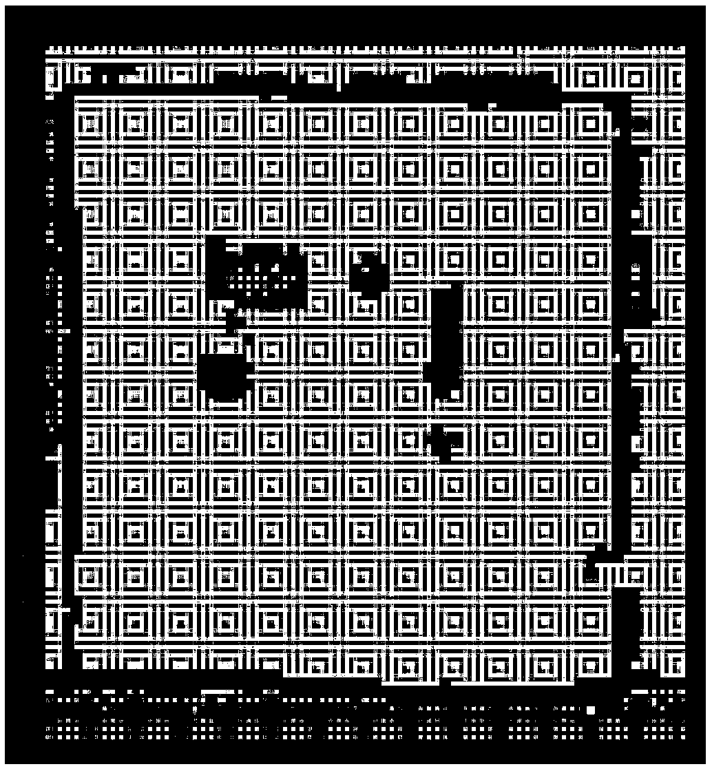
[0090] 2D raster map such as figure 1 As shown, the stored information includes the number of pixels in each row and the total number of rows of the map image. Each pixel in the map represents a plane area with a length and width of 5 cm in the real environment. Black pixels represent obstacles in this area, and white pixels represent this area. There are no obstacles.

[0091] In this example, the width of the map image is 50 pixels, and the height is 60 pixels, which represents an experimental site with a width of 2.5 meters and a length of 3 meters, such as figure 2 shown.

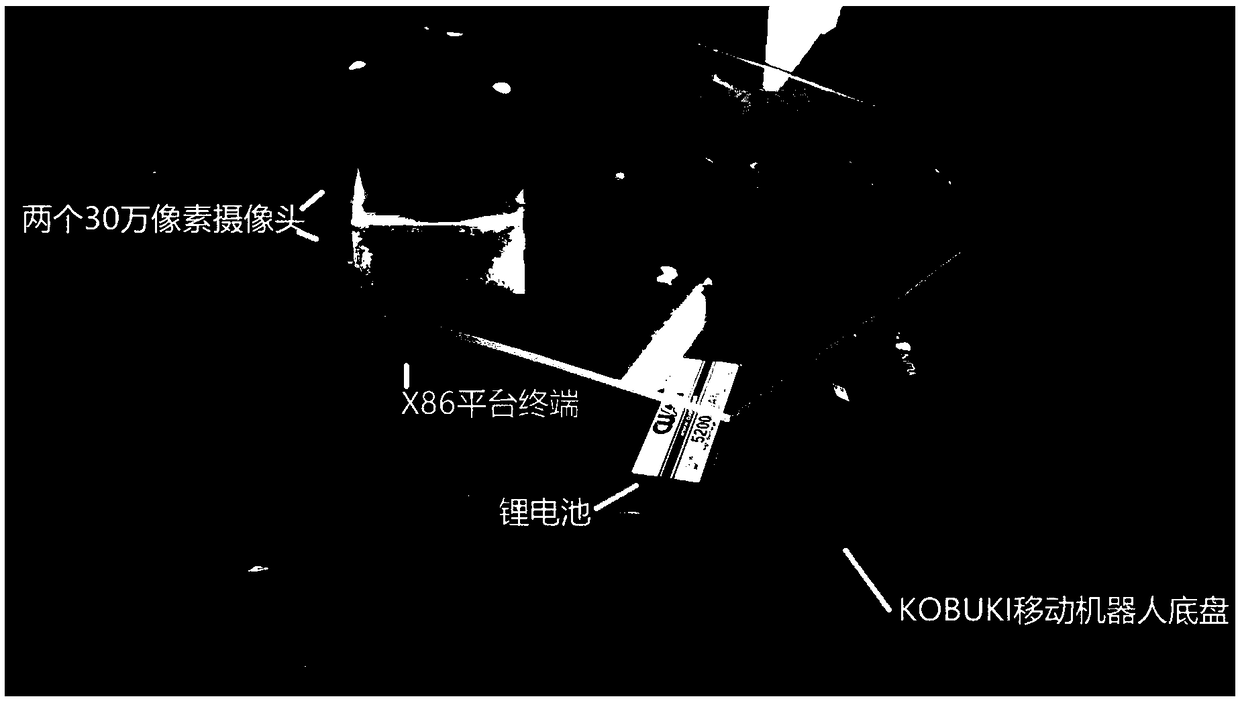
[0092] (2) Mobile robot platform model

[0093] In the selection of the mobile robot hardware platform, KOBUKI universal mobile robot base, LSLIDAR2D lidar and two ordinary 300,000-pixel camer...


PUM


Abstract

The invention discloses a mobile robot navigation method based on a binocular camera and a two-dimensional laser radar. The mobile robot navigation method includes the steps that a two-dimensional grid map model is built; a mobile-robot pose model is built; a laser radar data model is built; a joint calibration model of the binocular camera and the laser radar is established; route planning and obstacle avoidance navigation are carried out with the Dijkstra algorithm and the A-Star algorithm. According to the mobile robot navigation method, the relative position and the relative orientation ofthe binocular camera and the two-dimensional laser radar can be determined with the triangle joint calibration method; in the known-environment two-dimensional grid map environment, the binocular camera can be used for detecting barriers higher than and lower than the two-dimensional laser radar plane, the barriers can be mapped into an environment map, through the shortest path algorithm and heuristic search optimization, a navigation path line capable of avoiding the barriers is obtained, and a mobile robot can reach the destination along a path capable of avoiding the barriers in the movement process.

Description

technical field [0001] The invention relates to the technical field of mobile robot navigation, in particular to a mobile robot navigation method based on a binocular camera and a two-dimensional laser radar. Background technique [0002] With the high development of science and technology, the application fields of robot system are more and more extensive, such as industry, agriculture, medical treatment and so on. With the widespread application of robotic systems, intelligence has become an important direction of its development, and mobile robots use environmental maps to navigate is an important work in the field of intelligent robotics. [0003] In recent years, mobile robots have made gratifying achievements in many fields such as creating maps, tracking and positioning, autonomous planning, autonomous navigation, and autonomous obstacle avoidance in real environments. The basic theoretical basis of mobile robot navigation has been developed, and various implementati...

Claims


Application Information

Patent Timeline
IPC IPC(8): G01S17/02G01S17/93G01C21/20
CPCG01C21/20G01S17/93G01S17/86
Inventor 毕盛冯里千董敏张粤王永兴张英杰闵华清
Owner SOUTH CHINA UNIV OF TECH
Why Eureka
Try Eureka