Polarization navigation real-time positioning method based on all skylight degree of polarization information

A technology of real-time positioning and polarization navigation, applied in astronomical navigation, ground navigation, etc., to achieve the effects of strong adaptability, good stability, and strong environmental adaptability

Active Publication Date: 2018-11-06
BEIHANG UNIV
View PDF8 Cites 28 Cited by
  • Summary
  • Abstract
  • Description
  • Claims
  • Application Information

AI Technical Summary

Problems solved by technology

The Chinese patent 201410088363.5 that has been applied for, "Positioning system and positioning method based on multi-directional polarized light navigation sensor", uses two polarization sensor structures to measure the polarization vector

Method used


Image

  • Polarization navigation real-time positioning method based on all skylight degree of polarization information
  • Polarization navigation real-time positioning method based on all skylight degree of polarization information
  • Polarization navigation real-time positioning method based on all skylight degree of polarization information

Examples


Embodiment Construction

[0034] The present invention will be further described below in conjunction with the accompanying drawings and specific embodiments.

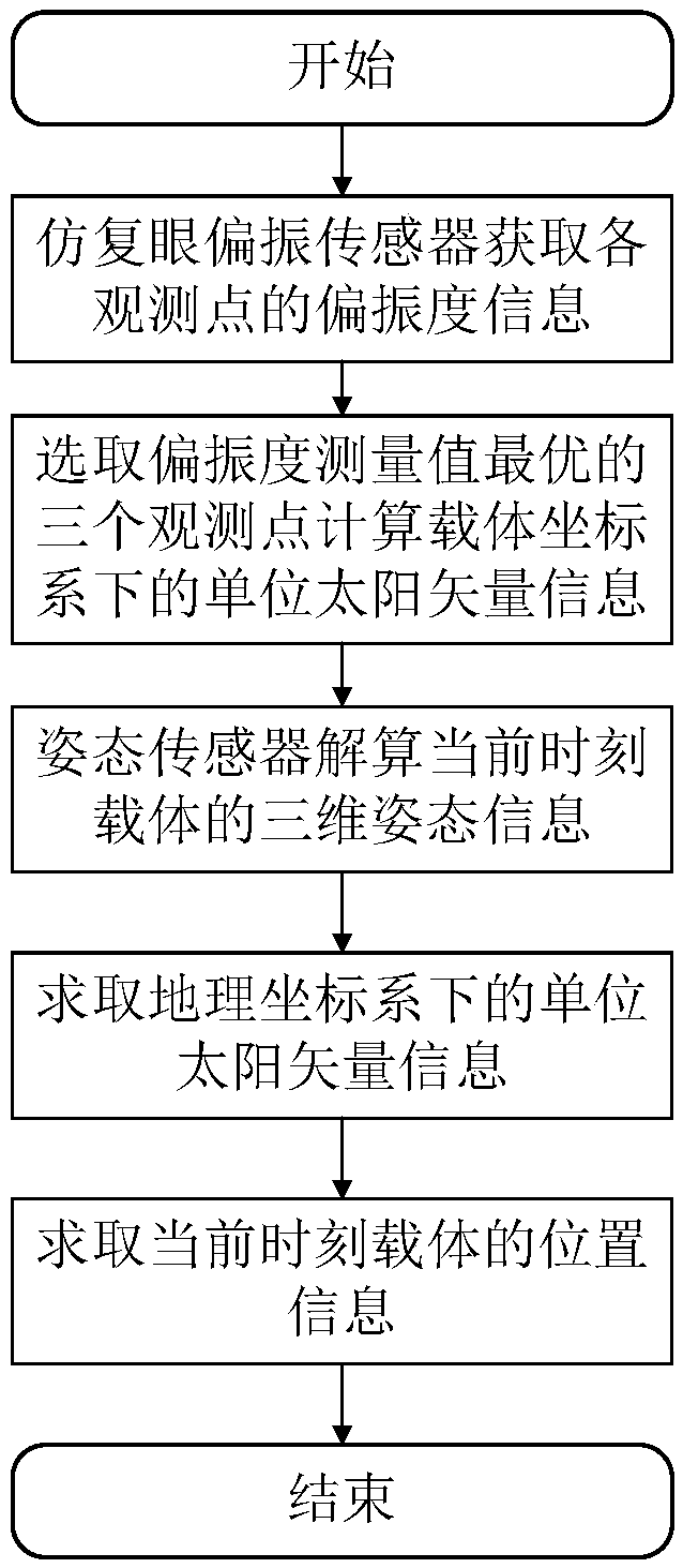
[0035] Such as figure 1 As shown, the specific implementation steps of a polarization navigation real-time positioning method based on the polarization degree information of the whole sky in the present invention are as follows:

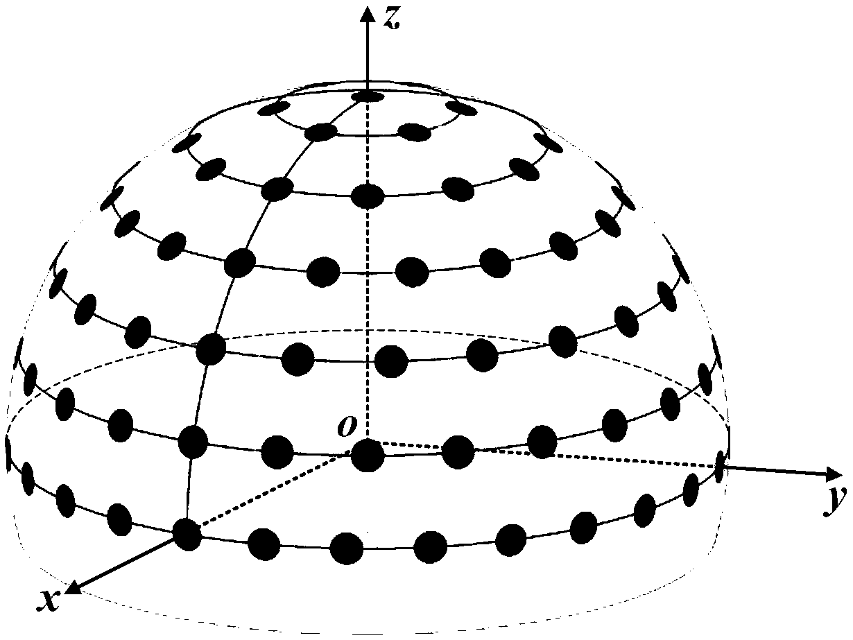
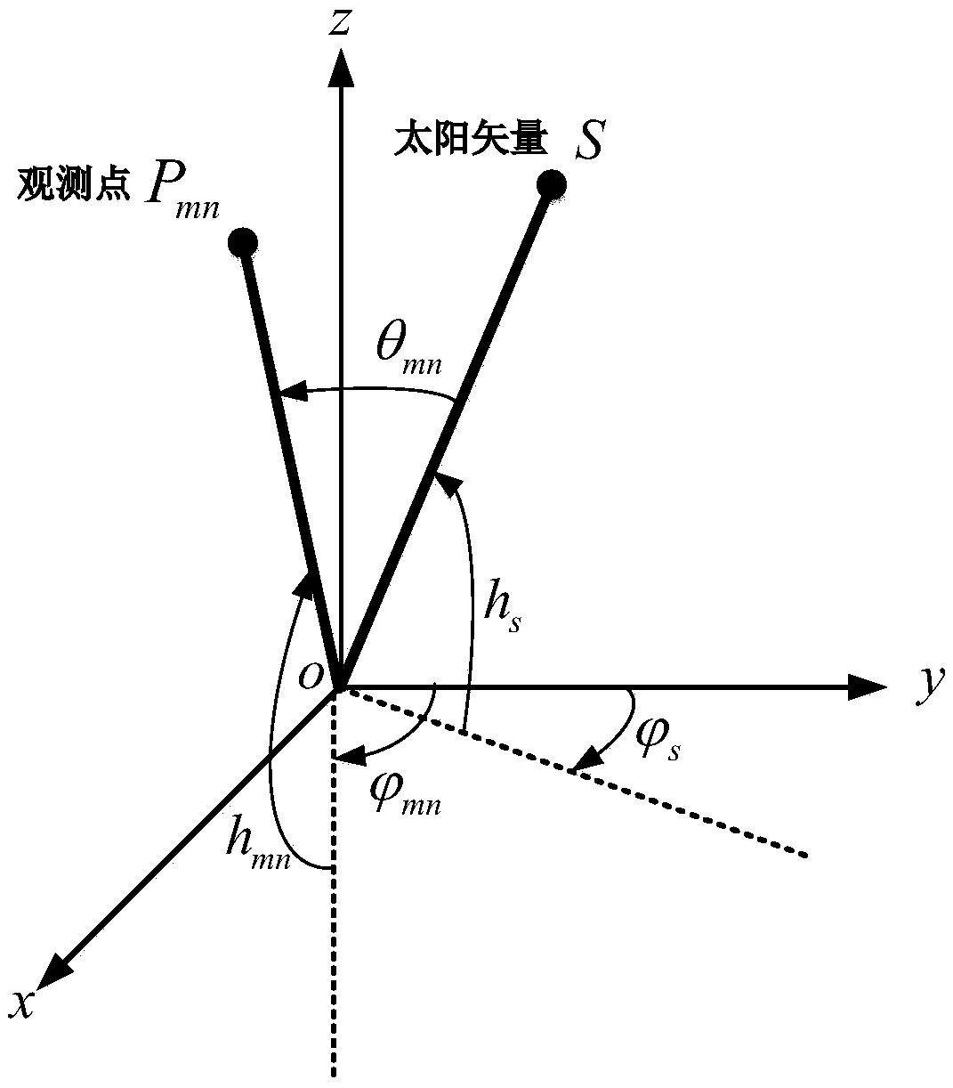
[0036] 1. The imitation compound eye polarization sensor in the sensor coordinate system is distributed on the longitude circle and latitude circle on the surface of the hemisphere in an array of polarization sensors, and the overall viewing angle can reach 180° (such as figure 2 shown). The observation point corresponding to each polarization sensor can be expressed as P mn , the corresponding degree of polarization information is d mn , where m is expressed as the mth latitude circle downward from the apex of the hemisphere, and n is expressed as the nth observation point clockwise from the y-axis. The observat...


PUM


Abstract

The invention relates to a polarization navigation real-time positioning method based on all skylight degree of polarization information. Aiming at the polarization navigation positioning problem, atfirst, the degree of polarization information of observation points of all skylight is acquired by a compound eye simulated polarization sensor, three optimal observation points in the degree of polarization information measured by the compound eye simulated polarization sensor are selected, the degrees of polarization of the three observation points are used as resolving input information, and are combined with the space geometry relation among the selected three observation points to obtain unit sun vector information in a vector system; then the three-dimensional attitude information of a vector at the current moment is acquired by an attitude sensor, and an attitude conversion matrix is acquired; next, the unit sun vector in the vector system is converted into a unit sun vector in a geography system by the attitude conversion matrix; and at last, through inquiring position information of a module calculation vector through an astronomical ephemeris, the polarization navigation positioning function is realized. The method is high in real-time performance, relatively high in precision, and relatively high environmental suitability, and can complete the positioning in a three-dimensional space.

Description

technical field [0001] The invention relates to the field of navigation and positioning of moving bodies, in particular to a polarization navigation real-time positioning method based on all-sky polarization degree information, which can be used for autonomous navigation and positioning of aviation aircraft, marine ships or ground mobile vehicles. Background technique [0002] Navigation is a key technology for measuring and estimating physical quantities such as carrier position, velocity and attitude. The main task of navigation and positioning is to obtain the position information of the carrier. High stability and high reliability navigation and positioning technology is the core technology for spacecraft, aircraft, ground robots, etc. to achieve tasks such as earth observation, remote sensing, surveying and mapping, reconnaissance and military strikes. At present, satellite navigation is a commonly used navigation and positioning method. However, satellite navigation i...

Claims


Application Information

Patent Timeline
IPC IPC(8): G01C21/02G01C21/04
CPCG01C21/02G01C21/04
Inventor 郭雷张青云胡鹏伟杨健王善澎杨悦婷
Owner BEIHANG UNIV
Why Eureka
Try Eureka