A Coordinate Correction Method of Massive Benchmarking Points Based on Leveling Route Distribution Map

A technology of benchmarking points and road maps, which is applied in the field of coordinate correction of massive benchmarking points based on leveling route distribution maps, to achieve the effect of satisfying data accuracy, improving work efficiency, and reducing manual review time

Inactive Publication Date: 2021-10-08
THE FIRST MONITORING CENT OF CHINA EARTHQUAKE ADMINISTATION
View PDF6 Cites 0 Cited by
  • Summary
  • Abstract
  • Description
  • Claims
  • Application Information

AI Technical Summary

Problems solved by technology

[0005] The purpose of the present invention is to provide a method for correcting the coordinates of a large number of leveling points based on the leveling route distribution map, thereby solving the aforementioned problems in the prior art

Method used


Image

  • A Coordinate Correction Method of Massive Benchmarking Points Based on Leveling Route Distribution Map
  • A Coordinate Correction Method of Massive Benchmarking Points Based on Leveling Route Distribution Map
  • A Coordinate Correction Method of Massive Benchmarking Points Based on Leveling Route Distribution Map

Examples


Embodiment 1

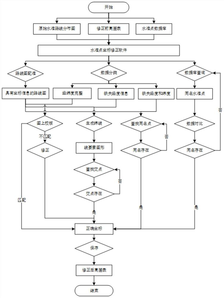
[0038] This embodiment mainly records the process of how to directly modify the wrong benchmarking point directly from the data in the database

[0039] S1 data preparation, obtaining data to be processed;

[0040] Prepare the original leveling route map, the height look-up table before correction and the benchmarking point database.

[0041] S2 registers the data to be processed with the leveling roadmap based on the geographic information system;

[0042] Use GIS method to match and map the geographic coordinates of the original road map.

[0043] S3 classifies the data points with deviation in position, and corrects the height difference table before;

[0044] The data to be corrected "Ⅲ Hualian 28" is the wrong data of latitude.

[0045] Before making the modification, first conduct a database query and find that "Ⅲ Hualian 28" has corrected data in the database, so directly replace the correct coordinates in the database with the high lookup table.

[0046] The coordi...

Embodiment 2

[0050] This embodiment mainly records the point correction process of longitude error

[0051] S1 data preparation, obtaining data to be processed;

[0052] Prepare the original leveling route map, the height look-up table before correction and the benchmarking point database.

[0053] S2 registers the data to be processed with the leveling roadmap based on the geographic information system;

[0054] Use GIS method to match and map the geographic coordinates of the original road map.

[0055] S3 classifies the data points with deviation in position, and corrects the height difference table before;;

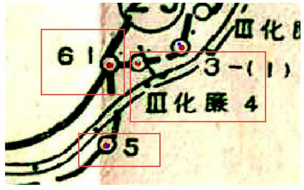
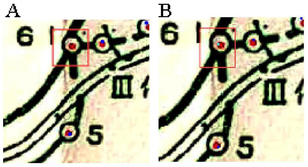
[0056] Such as figure 2 As shown, according to the order of the benchmarking points on the survey line, "II Nanfo 61" should be between "III Hualian 4" and "III Hualian 5", but this point is far away from the theoretical position on the map , is a point with obvious wrong latitude and longitude, which needs to be corrected.

[0057] Before the correction, the database query ...

Embodiment 3

[0064] This embodiment records the corrected coordinates of benchmarking points that lack longitude information

[0065]S1 and S2 are the same as in Example 2, the benchmark "Ⅲ Hualian 38" lacks longitude information, the software generates the latitude that runs through the map according to the dimension of the benchmark, and "Ⅲ Hualian 38" can be obtained through the intersection set of parallels and survey lines 38” possible coordinate range, and then the only intersection point can be obtained according to the context relationship of the two adjacent points of the survey line “Ⅲ Hualian 28” and “Ⅲ Hualian 64”. The coordinates of the intersection point are the correct coordinates of the benchmarking point, and the modification operation After storage.

[0066] The coordinates before and after modification are shown in Table 3, and the check before and after correction is as follows image 3 shown.

[0067] Table 3 Coordinates before and after correction of "III Hualian 38...


PUM


Abstract

The invention discloses a method for correcting coordinates of massive leveling points based on a leveling route distribution map, and relates to the technical fields of surveying and surveying engineering. The method includes the following steps: data preparation, obtaining the data to be processed; registering the data to be processed with the leveling road map based on the geographic information system; classifying the data points with deviations in position, and correcting the height difference table before; querying whether the database has Same point; correct the classification data points on the benchmarking plot. The correction method provided by the invention can effectively restore the missing latitude and longitude information, the data accuracy meets the requirements, and the digital efficiency of table lookup with high paper quality is greatly improved.

Description

technical field [0001] The invention relates to the technical field of surveying and surveying engineering, in particular to a method for correcting massive leveling point coordinates based on a leveling route distribution map. Background technique [0002] In the archives of the leveling height difference tables currently stored by the Earthquake Administration, the longitude and even all coordinate information of all benchmark points have been deleted from the paper height difference tables with a slightly older history. big trouble. Gross errors will inevitably occur in the process of digitization of historical paper-based height difference tables, especially the gross errors of benchmarking point coordinates will lead to inaccurate adjustment results. This kind of error is very subtle, and even after repeated comparisons, the correctness of the data cannot be fully guaranteed. In view of the problem that the traditional digital means cannot effectively recover the miss...

Claims


Application Information

Patent Timeline
Patent Type & Authority Patents(China)
IPC IPC(8): G06F16/29
Inventor 刘文龙薄万举马庆尊吕健张超
Owner THE FIRST MONITORING CENT OF CHINA EARTHQUAKE ADMINISTATION
Why Eureka
Try Eureka