Remote sensing and GIS-based desert ecosystem red directory assessment method

A technology for ecosystems and deserts, applied in the fields of instruments, calculations, and electrical digital data processing, etc., can solve the problems of lack of quantitative indicators in the process of ecosystem change, difficulty in determining the basic unit of assessment, and difficulty in unifying the classification of ecosystems. Simple and easy to operate, intuitive results, easy to promote the effect of application

Active Publication Date: 2018-11-23
NANJING INST OF ENVIRONMENTAL SCI MINIST OF ECOLOGY & ENVIRONMENT OF THE PEOPLES REPUBLIC OF CHINA
View PDF13 Cites 5 Cited by
  • Summary
  • Abstract
  • Description
  • Claims
  • Application Information

AI Technical Summary

Problems solved by technology

[0012] Aiming at the problems such as difficulty in unifying the classification of ecosystems in the division process of the existing ecosystem red list, difficulty in determining the basic unit of assessment, lack of quantitative indicato

Method used


Image

  • Remote sensing and GIS-based desert ecosystem red directory assessment method
  • Remote sensing and GIS-based desert ecosystem red directory assessment method
  • Remote sensing and GIS-based desert ecosystem red directory assessment method

Examples


Embodiment 1

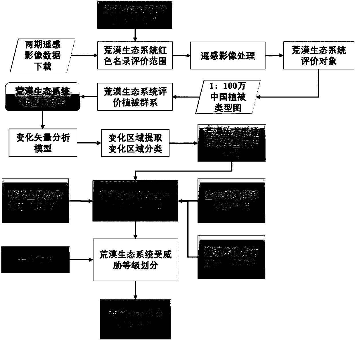
[0042] This embodiment discloses the evaluation method of the desert ecosystem red list based on remote sensing and GIS taking my country's desert ecosystem as an example. The flow chart of the desert ecosystem red list evaluation method is as follows figure 1 As shown, it specifically includes the following steps:

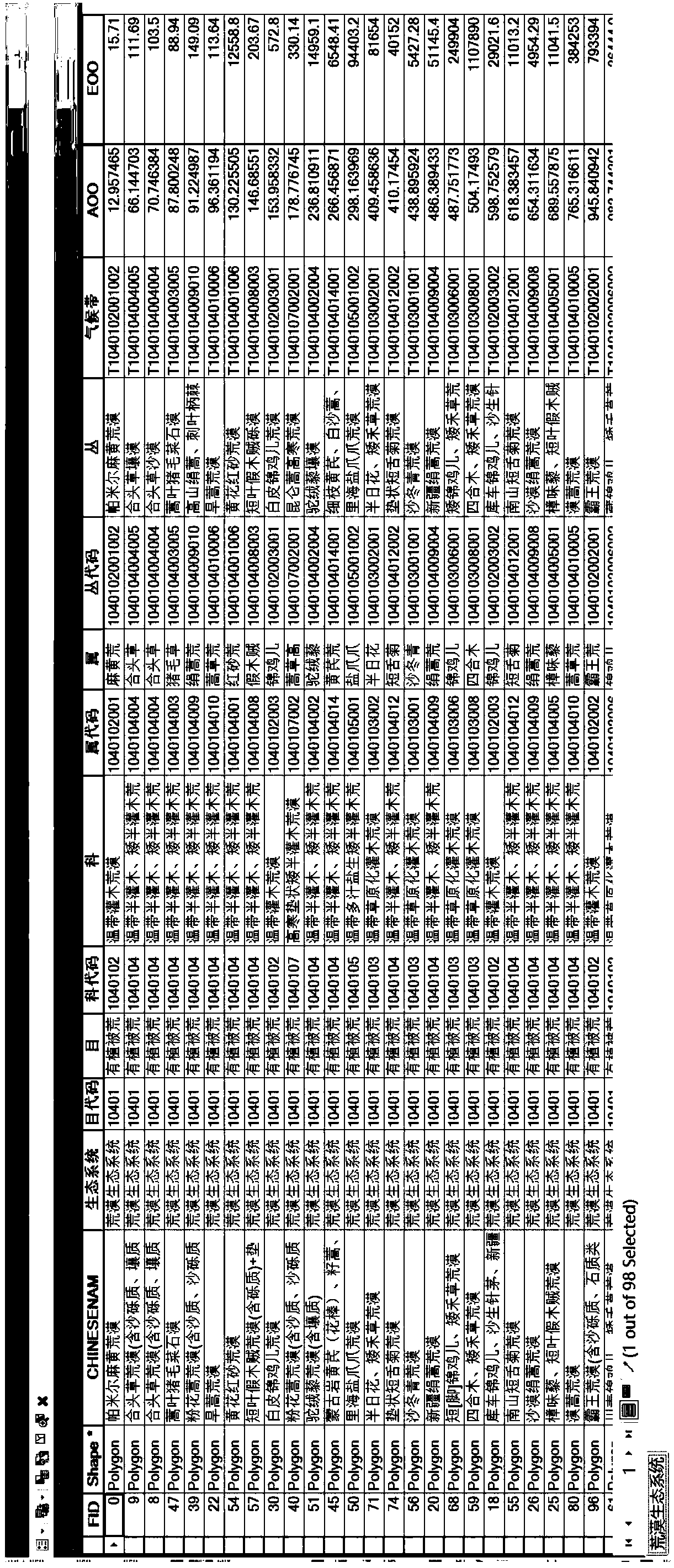
[0043] (1) To meet the needs of the desert ecosystem red list, construct a desert ecosystem classification system. It is divided into 2 orders, 16 families, 50 genera, and 113 clusters. See Table 2 for the desert ecosystem classification system.

[0044] Table 2 Red list classification system of desert ecosystems

[0045]

[0046]

[0047]

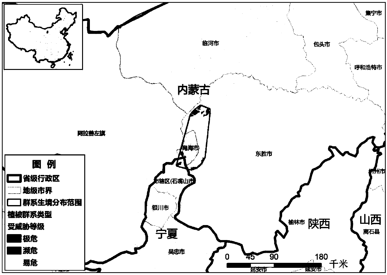
[0048] (2) List the land distributed in arid and semi-arid areas with vegetation coverage lower than 4% as the evaluation scope of the red list of desert ecosystems. Use the GIS software ArcGIS to build a geospatial database, and set a unified projection and geographic coordinate system according to the scope of th...


PUM


Abstract

The invention discloses a remote sensing and GIS-based desert ecosystem red directory assessment method, and belongs to the technical field of biodiversity protection. The method comprises the following steps of: (a) constructing a desert ecosystem classification system; (b) dividing desert ecosystem evaluation vegetation formations; (c) establishing a desert ecosystem threat level assessment standard; (d) calculating a desert ecosystem threat assessment index; (e) dividing desert ecosystem threat levels; and (f) constructing a desert ecosystem red directory. According to the method, rapid desert ecosystem red directory threat level assessment is realized, directories are combined with spatial information of habitat patch degradation so as to provide basis for protection and management oflarge-scale ecosystems, and the problems that ecosystem classification in the existing ecosystem red directory division process is difficult to unify, assessment basic units are difficult to determine, the ecosystem change processes are lack of quantification indexes and batch evaluation is difficult to realize in the macro scale are overcome.

Description

technical field [0001] The invention belongs to the technical field of biodiversity protection, and relates to an evaluation method of a desert ecosystem red list based on remote sensing and GIS. Background technique [0002] Biodiversity is the material basis of living systems, which can directly provide living space for humans and other organisms, and provide organisms with suitable habitats and various services through the exertion of ecological functions. However, due to climate change and the intensification of human activities, global biodiversity continues to be lost. Biodiversity assessment is the premise of formulating conservation measures. Traditional biodiversity assessment mainly focuses on species diversity, which has shortcomings such as insufficient representation of biodiversity and inability to respond to changes in ecosystem diversity in a timely manner. Protecting the ecosystem as a whole can more effectively ensure the coordinated development of natural...

Claims


Application Information

Patent Timeline
IPC IPC(8): G06F17/30G06K9/62
CPCG06F18/2193G06F18/241
Inventor 单楠周可新唐夫凯潘扬
Owner NANJING INST OF ENVIRONMENTAL SCI MINIST OF ECOLOGY & ENVIRONMENT OF THE PEOPLES REPUBLIC OF CHINA
Why Eureka
Try Eureka