DEM-auxiliary-intensity-related glacier surface motion three-dimensional vector inversion method

A three-dimensional vector, glacier technology, applied in the reflection/re-radiation of radio waves, measurement devices, 3D modeling, etc., to reduce offset errors, improve accuracy, and improve image registration accuracy.

Active Publication Date: 2018-11-30
CHINA AERO GEOPHYSICAL SURVEY & REMOTE SENSING CENT FOR LAND & RESOURCES
View PDF3 Cites 15 Cited by
  • Summary
  • Abstract
  • Description
  • Claims
  • Application Information

AI Technical Summary

Problems solved by technology

[0005] The purpose of the present invention is to provide a DEM-assisted strength-related three-dimensional vector inversion method for glacier surface motion, thereby solving the aforementioned problems in the prior art

Method used


Image

  • DEM-auxiliary-intensity-related glacier surface motion three-dimensional vector inversion method
  • DEM-auxiliary-intensity-related glacier surface motion three-dimensional vector inversion method
  • DEM-auxiliary-intensity-related glacier surface motion three-dimensional vector inversion method

Examples


specific Embodiment

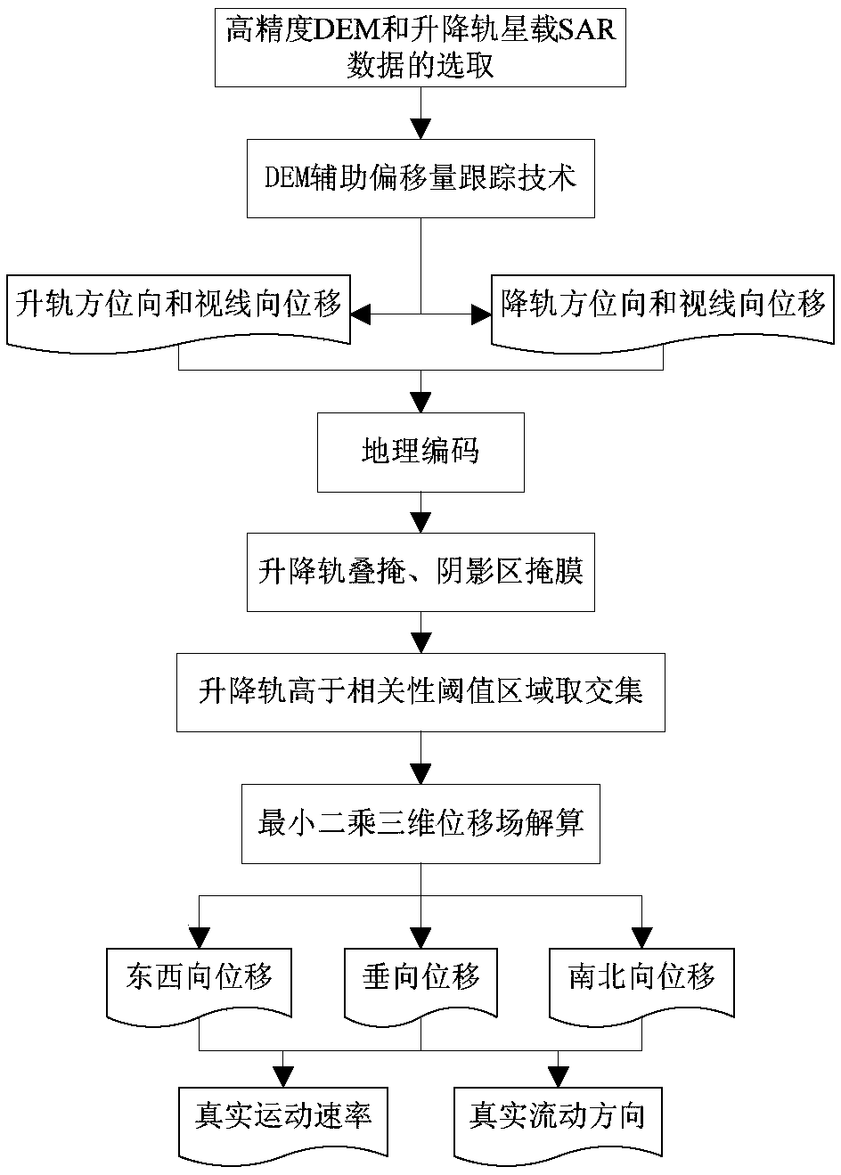
[0114] Taking the estimation of the three-dimensional vector of the surface motion of the Yiga Glacier in Jiali County, Nagqu, Tibet as an example, the specific operation steps of the present invention in practical application are illustrated. Such as figure 1 As shown, the embodiment of the present invention can be implemented according to the following specific steps:

[0115] Step 1: Select high-precision DEM and satellite-borne SAR data of ascending and descending orbits.

[0116] The COSMO-SkyMed radar satellite is a constellation composed of four X-band high-resolution radar satellites, which can quickly obtain the ascending and descending orbit SAR image pairs with similar time distribution in the same area, and select the ascending and descending orbit COSMO-SkyMed data covering the Yiga Glacier, for The HImage imaging mode acquires images with a resolution of 3 m, the polarization mode is HH, and the time difference of the ascending and descending orbit data is only ...


PUM


Abstract

The invention discloses a DEM-auxiliary-intensity-related glacier surface motion three-dimensional vector inversion method, and relates to the technical field of glacier motion monitoring. Lifting rail SAR image pairs are registered at high precision based on a high-precision DEM, and then displacement observation results in four different directions of a glacier area are obtained by utilizing satellite-borne SAR amplitude information and applying an offset tracking technology; and shadowing and layover areas with the threshold value lower than the offset tracking relativity threshold value are masked, according to the SAR image forming geometrical relationship, the functional equation system between the deformation observation results of the four directions and three-dimensional motion components of three glaciers in the east-west, south-north and vertical directions is built, the three-dimensional motion components are calculated, and then the actual flowing speed and direction of the surfaces of the glaciers are obtained. Actual three-dimensional motion on the surfaces of the glaciers is inversed only through satellite-borne SAR, when the terrain is steep and an SAR image spacebase line is large, the offset error is lowered, and the precision of the offset tracking result is improved.

Description

technical field [0001] The invention relates to the technical field of glacier motion monitoring, in particular to a DEM-assisted strength-correlated three-dimensional vector inversion method for glacier surface motion. Background technique [0002] Mountain glaciers are an important part of glaciers and are sensitive recorders and indicators of global climate change. Glacier movement is one of the important characteristics of glaciers, which can cause natural disasters such as mudslides and glacial lake outbursts that seriously threaten human production and life. Retrieving the real flow conditions on the glacier surface has important reference significance for predicting glacier flow and disaster occurrence. However, mountain glaciers are generally located in areas with harsh natural environments, and it is difficult to conduct regular and large-scale on-site monitoring. The emergence of remote sensing provides the possibility of low-cost, high-frequency, and large-scale m...

Claims


Application Information

Patent Timeline
Patent Type & Authority Applications(China)
IPC IPC(8): G01S13/90G06T17/05
CPCG01S13/9029G06T17/05G01S13/9023
Inventor 范景辉郭兆成童立强赵红丽袁蔚林
Owner CHINA AERO GEOPHYSICAL SURVEY & REMOTE SENSING CENT FOR LAND & RESOURCES
Why Eureka
Try Eureka