
Method, system and ground-based navigation beacon for monitoring building deformation using radio and television data broadcasting

A deformation monitoring and data broadcasting technology, applied in the field of satellite navigation, can solve the problems of expensive construction, large amount of communication data, payment of communication fees, etc., and achieve the effect of reducing data communication volume, expanding imagination space, and reducing system cost

Active Publication Date: 2020-06-23
北京因子图导航技术有限公司
View PDF6 Cites 0 Cited by
  • Summary
  • Abstract
  • Description
  • Claims
  • Application Information

AI Technical Summary

Problems solved by technology

In the traditional building deformation monitoring technology, the deformation monitoring terminal needs to continuously send the "raw navigation observations" of satellite navigation to the deformation monitoring center, and the amount of communication data is relatively large. Generally, it is based on a dedicated regional wireless network, optical fiber or mobile communication. As a means of information transmission between systems, the network either cannot cover a large area, or the construction is expensive, or requires continuous payment of communication fees, which limits the large-scale application of deformation monitoring technology

Method used


Image

  • Method, system and ground-based navigation beacon for monitoring building deformation using radio and television data broadcasting
  • Method, system and ground-based navigation beacon for monitoring building deformation using radio and television data broadcasting
  • Method, system and ground-based navigation beacon for monitoring building deformation using radio and television data broadcasting

Examples


Embodiment 1

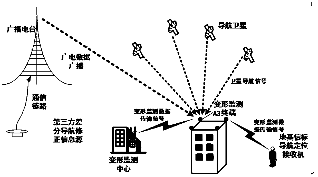
[0060] A building deformation monitoring system using radio and television data broadcasting, see figure 1 , figure 2 with image 3 .

[0061] figure 1 It is a schematic diagram of a building deformation monitoring system using radio and television data broadcasting according to the present invention. Such as figure 1 The shown deformation monitoring system based on radio and television data broadcasting involves broadcasting stations, deformation monitoring terminals, deformation monitoring centers and ground-based beacon navigation and positioning receivers.

[0062] Taking the deformation monitoring of a building in the residential area as an example, the broadcasting station broadcasts differential navigation correction information to all deformation monitoring terminals through radio and television data broadcasting. Here, the differential navigation correction information usually comes from a third-party differential navigation correction information source.

[0063] For a ce...

Embodiment 2

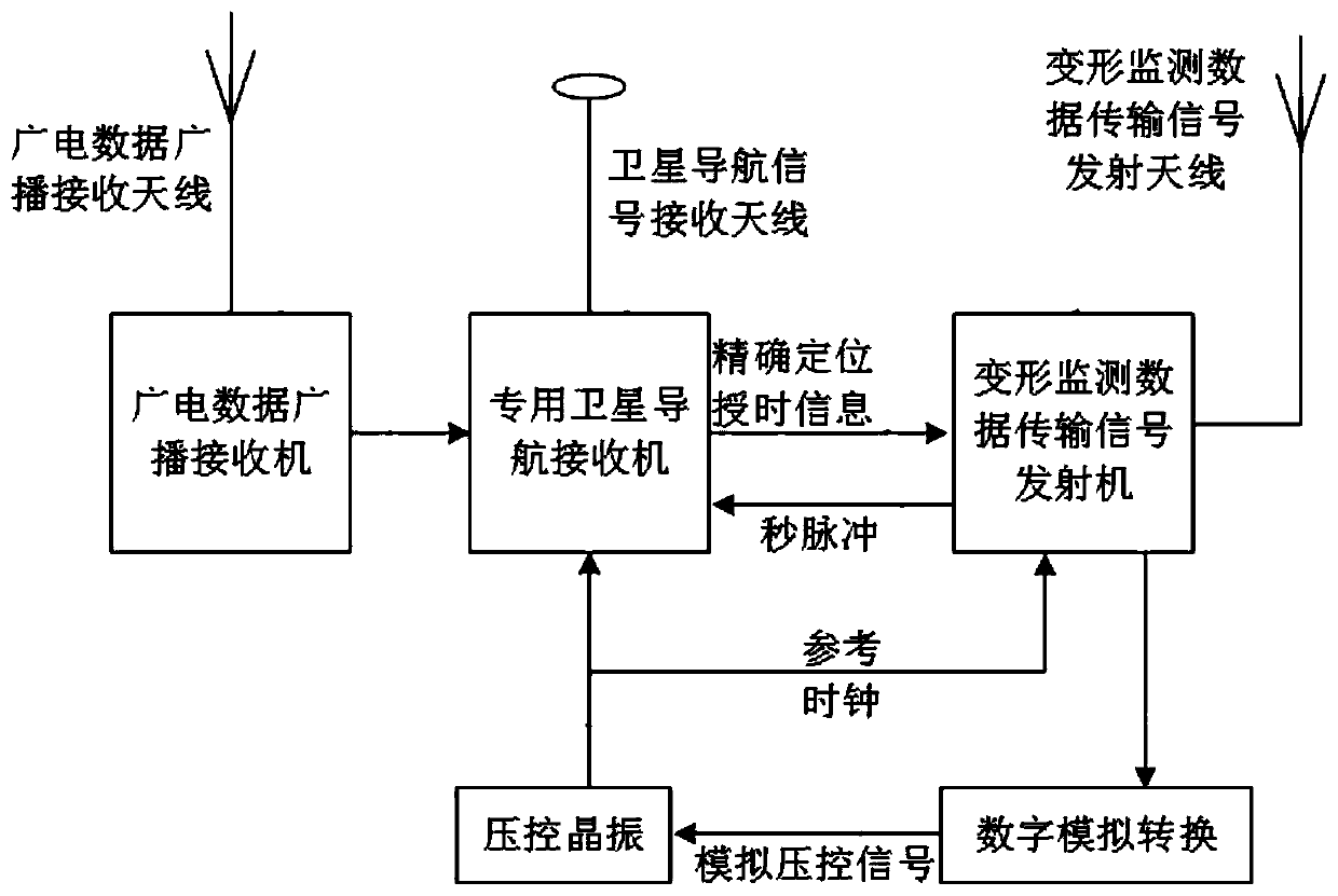
[0092] See Figure 4 , A deformation monitoring terminal, which mainly includes radio and television data broadcasting receiving antenna, radio and television data broadcasting receiver, satellite navigation receiving antenna, dedicated satellite navigation receiver, deformation monitoring data transmission signal transmitter, deformation monitoring data transmission signal transmitting antenna, digital analog Conversion module and voltage controlled crystal oscillator.

[0093] The radio and television data broadcast receiving antenna receives the radio and television data broadcast signal, and transmits it to the radio and television data broadcast receiver.

[0094] The radio and television data broadcast receiver demodulates the radio and television data broadcast signal, and extracts the differential navigation correction information.

[0095] The satellite navigation signal receiving antenna receives the satellite navigation signal and transmits it to the general satellite navi...

Embodiment 3

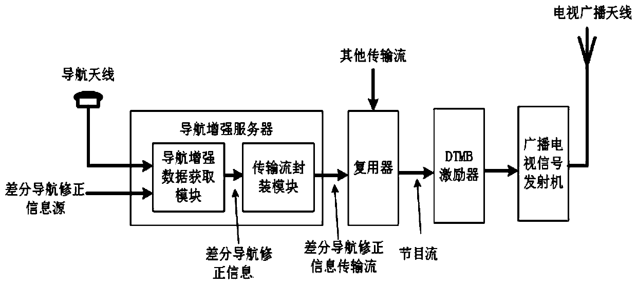
[0106] See Figure 5 , Image 6 with Figure 7 According to the present invention, a method for using the building deformation monitoring system using radio and television data broadcasting mainly includes the following steps:

[0107] 1) The broadcasting station broadcasts differential navigation correction information through radio and television data broadcasting signals. Such as Image 6 As shown, when the radio and television data broadcast signal is a DTMB signal, it is further divided into the following steps:

[0108] 1.1) The navigation enhancement server encapsulates the differential navigation correction information into a differential navigation correction information transmission stream, and sends it to the multiplexer.

[0109] 1.2) The multiplexer multiplexes the differential navigation correction information transmission stream as a program to the program stream and sends it to the DTMB exciter.

[0110] 1.3) The DTMB exciter maps the program stream into a DTMB physica...


PUM


Abstract

The invention discloses a building deformation monitoring method and system with radio and television data broadcasting and a ground-based navigation beacon. The system mainly comprises a broadcastingstation, a deformation monitoring terminal, a deformation monitoring center and a ground-based beacon navigation and positioning receiver. The ground-based navigation beacon transmits signals for thedeformation monitoring data. Besides, the method comprises: step one, a broadcasting station broadcasts differential navigation correction information; step two, the deformation monitoring terminal receives a satellite navigation signal and differential navigation correction information; step three, the deformation monitoring terminal acquires own precise positioning timing information; step four, the deformation monitoring terminal sends the own positioning timing information to the deformation monitoring center and / or the ground-based beacon navigation positioning receiver; and step five, the deformation monitoring center receives the data transmission signal to perform deformation monitoring on a building where the deformation monitoring terminal is located. The building deformation monitoring method and system and the ground-based navigation beacon are suitable for deformation monitoring of buildings and / or non-buildings such as mountains.

Description

Technical field [0001] The invention relates to the technical field of satellite navigation, in particular to a building deformation monitoring method, system and ground-based navigation beacon using radio and television data broadcasting. Background technique [0002] According to the "Engineering Survey Code GB50026-2007", deformation monitoring refers to the displacement, settlement, tilt, deflection, cracks and related influencing factors (such as the displacement, settlement, inclination, deflection, cracks, etc.) of structures and their foundations, building foundation pits, or rock and soil within a certain range Groundwater, temperature, stress and strain, etc.) are monitored, and the process of deformation analysis and prediction is provided. [0003] In recent years, with the rapid development of the civil construction industry, various high-rise civil buildings and large buildings such as bridges and dams have continued to emerge. In order to prevent the damage caused b...

Claims


Application Information

Patent Timeline
Patent Type & Authority Patents(China)
IPC IPC(8): G01B21/32G01S1/02H04H20/53H04H20/72
CPCG01B21/32G01S1/02H04H20/53H04H20/72
Inventor 李璨
Owner 北京因子图导航技术有限公司
Learn More