Location method and system, and handheld intelligent wearing device

A smart wearable device and portable technology, applied in satellite radio beacon positioning system, radio wave measurement system, measuring device, etc., can solve the problems of GPS signal interference positioning accuracy, affecting user experience, and inaccurate users, etc., to achieve Simplify the process of precise positioning, improve the navigation experience, and reduce the effect of positioning complexity

Inactive Publication Date: 2018-12-07
PHICOMM (SHANGHAI) CO LTD
View PDF8 Cites 12 Cited by
  • Summary
  • Abstract
  • Description
  • Claims
  • Application Information

AI Technical Summary

Problems solved by technology

[0003] In the existing technology, smart phones, smart watches and other smart wearable devices with GPS positioning function can usually be used as navigation tools. However, when navigating through smart phones, smart watches and other smart wearable devices, the user will , because the GPS signal is easily interfered by external factors such as weather or passing shelters, resulting in positioning accuracy, it cannot accurately navigate for users, which affects the user experience

Method used


Image

  • Location method and system, and handheld intelligent wearing device
  • Location method and system, and handheld intelligent wearing device
  • Location method and system, and handheld intelligent wearing device

Examples


Embodiment Construction

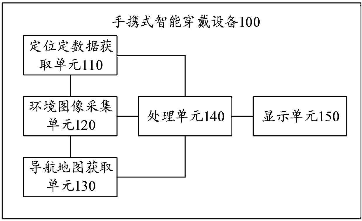
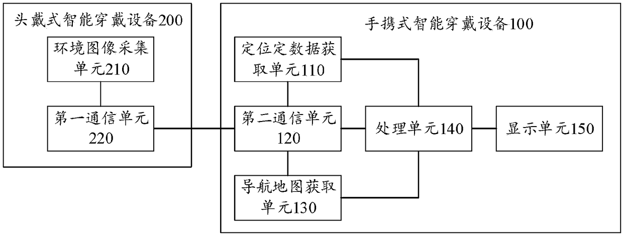
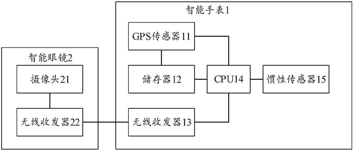
[0061] In order to more clearly illustrate the embodiments of the present invention or the technical solutions in the prior art, the specific implementation manners of the present invention will be described below with reference to the accompanying drawings. Obviously, the accompanying drawings in the following description are only some embodiments of the present invention, and those skilled in the art can obtain other accompanying drawings based on these drawings and obtain other implementations.

[0062] In order to make the drawing concise, each drawing only schematically shows the parts related to the present invention, and they do not represent the actual structure of the product. In addition, to make the drawings concise and easy to understand, in some drawings, only one of the components having the same structure or function is schematically shown, or only one of them is marked. Herein, "a" not only means "only one", but also means "more than one".

[0063] The first ...


PUM


Abstract

The present invention provides a location method and system, and a handheld intelligent wearing device. The method comprises the steps of: obtaining GPS location data and motion state data of a handheld location device, and obtaining environment image data and a navigation map, wherein the GPS location data, the motion state data and the environment image data comprise time stamps; matching the environment image data corresponding to the current moment with the navigation map to obtain a first position of a user at the current moment; and according to the first position, performing fusion operation of the GPS location data and the motion state data to determine the orientation location information corresponding to the current moment. The location method and system, and the handheld intelligent wearing device can improve the location accuracy through combination operation of the environment image data.

Description

technical field [0001] The invention relates to the field of mobile smart devices, in particular to a positioning method, a positioning system and a portable smart wearable device. Background technique [0002] With the continuous expansion of city scale and the continuous increase of people's activity range, people's location or environment is not the area they are familiar with in many cases. Therefore, it is more and more important to identify the direction in time and quickly determine the route to the destination. [0003] In the existing technology, smart phones, smart watches and other smart wearable devices with GPS positioning function can usually be used as navigation tools. However, when navigating through smart phones, smart watches and other smart wearable devices, the user will , because the GPS signal is easily interfered by external factors such as weather or passing shelters, resulting in positioning accuracy, it cannot accurately navigate for users, which ...

Claims


Application Information

Patent Timeline
Patent Type & Authority Applications(China)
IPC IPC(8): G01S19/45
CPCG01S19/45
Inventor 薛彬
Owner PHICOMM (SHANGHAI) CO LTD
Why Eureka
Try Eureka