Map data acquisition method

A technology of map data and acquisition method, applied in the field of data processing, can solve problems such as poor security, inaccurate positioning technology, positioning behavior decision-making and motion planning errors, etc., to achieve the effect of ensuring accuracy and ensuring safety

Inactive Publication Date: 2018-12-07
BEIJING ZHIXINGZHE TECH CO LTD
View PDF5 Cites 36 Cited by
  • Summary
  • Abstract
  • Description
  • Claims
  • Application Information

AI Technical Summary

Problems solved by technology

[0004] However, the existing positioning technology is not accurate enough. During the driving process, it often occurs that the vehicle is driving in the current lane, but is positioned in the side lane. Inaccurate positioning will lead to errors in behavior decision-making and motion planning, which will cause the vehicle Poor safety issues during driving

Method used


Image

  • Map data acquisition method

Examples


Embodiment Construction

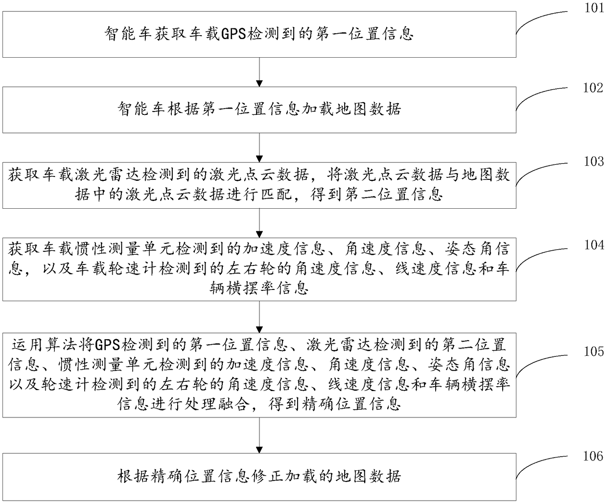
[0037] The technical solutions of the present invention will be described in further detail below with reference to the accompanying drawings and embodiments.

[0038] The map data acquisition method provided by the embodiment of the present invention is applied between a server and a plurality of smart cars, wherein a smart car can be understood as an unmanned self-driving vehicle, which can realize perception and positioning through its own environment perception module, and can Path planning and control are performed according to the perceived environmental information to realize intelligent and safe operation.

[0039] The smart car is equipped with an environmental perception module, which includes but is not limited to a camera, a laser radar, a global positioning system (Global Positioning System, GPS), an inertial measurement unit (Inertial measurement unit, IMU) and a wheel speedometer.

[0040] Among them, there can be multiple cameras and laser radars, which are res...


PUM


Abstract

The embodiment of the invention relates to a map data acquisition method, comprising the following steps: an intelligent vehicle acquiring first position information detected by a vehicle-mounted GPS;the intelligent vehicle loading map data according to the first position information; acquiring laser point cloud data detected by vehicle-mounted radar, matching the laser point cloud data with laser point cloud data in the map data to obtain second position information; acquiring inertial measurement data detected by a vehicle-mounted inertial measurement unit and wheel speed gauge data detected by a vehicle-mounted wheel speed gauge; conducting processing and fusion on the detected data through an algorithm, and obtaining accurate position information; correcting the loaded map data according to the accurate position information. A vehicle can be accurately positioned through fusion of detection data of a plurality of sensors, and the accuracy of positioning of the vehicle is guaranteed. Moreover, the map information is loaded in real time according to the accurate position of the vehicle, so that the vehicle can accurately make decision and make motion planning. In this way, the safety of the vehicle during automatic driving is guaranteed.

Description

technical field [0001] The invention relates to the field of data processing, in particular to a map data acquisition method. Background technique [0002] With the development of artificial intelligence technology and computer technology, autonomous driving technology is becoming more and more mature. Autonomous vehicles can efficiently utilize traffic resources, alleviate traffic congestion, and reduce carbon emissions. Autonomous driving technology has developed rapidly in recent years, and autonomous driving technology is also a hot topic in recent years. Autonomous driving technology has gradually entered people's daily life, subtly changing the way people travel. Autonomous driving technology has great application prospects in both military and civilian applications. For military use, it can be used not only as an unmanned transportation platform, but also as an unmanned demolition vehicle, unmanned combat platform, unmanned patrol and surveillance vehicle, etc.; in ...

Claims


Application Information

Patent Timeline
Patent Type & Authority Applications(China)
IPC IPC(8): G05D1/02G06F17/30
CPCG05D1/0257G05D1/027G05D1/0278
Inventor 张德兆王肖李晓飞张放霍舒豪
Owner BEIJING ZHIXINGZHE TECH CO LTD
Why Eureka
Try Eureka