The application of vehicle-mounted lidar system in highway reconstruction and expansion survey

A vehicle-mounted lidar and highway technology, applied in the directions of roads, roads, buildings, etc., can solve the problems of high cost, hidden safety hazards, low efficiency, etc., and achieve the effect of reducing comprehensive cost and improving operation efficiency.

Inactive Publication Date: 2018-12-18
SHANGHAI HUACE NAVIGATION TECH
View PDF5 Cites 9 Cited by
  • Summary
  • Abstract
  • Description
  • Claims
  • Application Information

AI Technical Summary

Problems solved by technology

At present, the method of aerial photogrammetry supplemented by GPS RTK measurement and precision leveling is mainly used, but there are defects such as low efficiency, high cost, and great safety hazards, which cannot meet the growing needs of road reconstruction and expansion construction.

Method used


Image

  • The application of vehicle-mounted lidar system in highway reconstruction and expansion survey

Examples


Embodiment Construction

[0017] In the following description, numerous specific details are given in order to provide a more thorough understanding of the present invention. It will be apparent, however, to one skilled in the art that the present invention may be practiced without one or more of these details. In other examples, some technical features known in the art are not described in order to avoid confusion with the present invention.

[0018] In order to thoroughly understand the present invention, detailed steps and detailed structures will be provided in the following description, so as to illustrate the technical solution of the present invention. Preferred embodiments of the present invention are described in detail below, however, the present invention may have other embodiments besides these detailed descriptions.

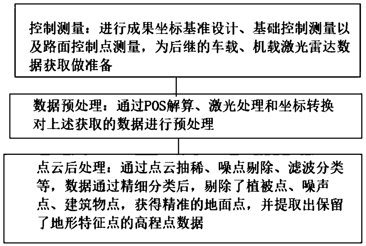
[0019] refer to figure 1 As shown, the present invention provides the application of the vehicle-mounted laser radar system in the highway reconstruction and expansion surv...


PUM


Abstract

The invention provides the application of the vehicle-mounted laser radar system in the highway reconstruction and expansion survey, comprising the following steps: control survey: carrying out the result coordinate reference design, the foundation control survey and the pavement control point measurement to prepare for the subsequent vehicle-mounted and airborne laser radar data acquisition; andthe vehicle-mounted laser radar system is used for the road reconstruction and expansion survey. Data pre-processing: POS solution, laser processing and coordinate conversion are used to pre-process the obtained data. Point cloud post-processing: through point cloud thinning, noise elimination, filtering classification and the like, after data is classified, vegetation points, noise points and building points are eliminated to obtain accurate ground points, and elevation point data retaining topographic characteristic points are extracted. Compared with the traditional method, the invention collects 100 kilometers of road data every day, and improves the operation efficiency by 5-7 times. The automation degree of indoor software is as high as 80 percent. Due to the improvement of operationefficiency and the decrease of manpower input, the comprehensive cost of indoor software is reduced by 4-5 times.

Description

technical field [0001] The invention relates to the field of highway reconstruction and expansion survey, in particular to the application of a vehicle-mounted laser radar system in highway reconstruction and expansion survey. Background technique [0002] Accurate acquisition of 3D information such as roads and their auxiliary structures is an important prerequisite for road reconstruction and expansion. For road reconstruction and expansion projects, in order to maximize the use of existing roads, it is first necessary to accurately restore the linear elements of the existing roads; in addition, in order to achieve accurate splicing of bridges, roadbeds, etc., compared with new road projects, its impact on measurement accuracy There are also higher requirements. At present, the method of aerial photogrammetry supplemented by GPS RTK measurement and precision leveling is mainly used, but there are defects such as low efficiency, high cost, and great safety hazards, which c...

Claims


Application Information

Patent Timeline
Patent Type & Authority Applications(China)
IPC IPC(8): E01C23/01
CPCE01C23/01
Inventor 赵路汪剑梁霄罗寒旭李早玲曹雪美贺成成
Owner SHANGHAI HUACE NAVIGATION TECH
Why Eureka
Try Eureka