High-precision geometric positioning post-processing method using image-compensated remote sensing image/SAR image

A remote sensing image and geometric positioning technology, which is applied to satellite radio beacon positioning systems, measuring devices, instruments, etc., can solve problems such as incapable of production operations, unsatisfactory geospatial information, and complicated operation processes, and achieve the effect of improving accuracy

Active Publication Date: 2018-12-18
HUAIYIN TEACHERS COLLEGE
View PDF4 Cites 9 Cited by
  • Summary
  • Abstract
  • Description
  • Claims
  • Application Information

AI Technical Summary

Problems solved by technology

The disadvantage is that the operation process is complicated, and the relevant parameters of the hardware equipment need to be known in the process of data processing in the office, and it is impossible to carry out production operations in overseas areas lacking surface control points or in harsh environments where surface operations cannot be performed
The traditional theory and process of photogrammetry cannot meet people's needs for high-precision and high-efficiency acquisition of geospatial information

Method used


Image

  • High-precision geometric positioning post-processing method using image-compensated remote sensing image/SAR image

Examples


Embodiment Construction

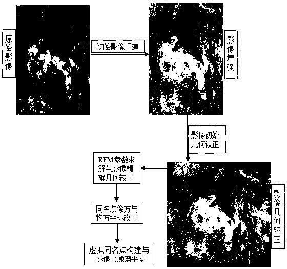
[0028] The technical implementation scheme of the present invention is described below by taking MODIS satellite remote sensing image processing as an example, but it should not be understood as a limitation to the technical scheme.

[0029] Step1. Use space-borne remote sensing images to construct stereoscopic image pairs or use space-borne SAR images to construct interferometric images, obtain and establish the RPC parameters and their databases in the attached files of the images; use GNSS to deploy the field control network, and its network layout adopts a static control network , or use the RTK operation form to collect the coordinates of the control points, and the operation process should meet the requirements of the corresponding national specifications;

[0030] Step2. The digital image quality inspection focuses on the inspection of the image resolution, the application of the steady-state re-imaging geometric model to restore the original image, and the establishment...


PUM


Abstract

The invention provides a post-processing method for geometric positioning of an object point using a remote sensing image/synthetic aperture radar (SAR) image. For the applied present situation that the accuracy of point position cannot meet requirements such as large and medium scale mapping, while using remote sensing image or SAR image to extract spatial location information of ground surfacesand ground objects; a linearized error equation is established according to a nonlinear mapping function of surface point image coordinate and object space coordinate, and a set of processing flow anda method for obtaining high-precision spatial position of ground surface and ground objects based on digital image is established by applying a model parameter estimation theory with errors-in-variables (EIV) contained in variables. The high-precision geometric positioning post-processing method is suitable for the block adjustment data processing of the space-borne optical remote sensing and thespace-borne SAR digital image, and can effectively solve the problem that the positioning accuracy is not high.

Description

technical field [0001] The invention relates to a method for obtaining geometric coordinates of surface points and its precision evaluation involved in industries such as aerospace photogrammetry, surveying and mapping, and computational mathematics, and specifically relates to a post-processing method for high-precision geometric positioning of remote sensing images / SAR images with image square compensation. Background technique [0002] Geometric positioning of surface points using spaceborne remote sensing images / spaceborne SAR images is an important application of spatial information technology in the geoscience industry. In recent years, with the construction of high-resolution earth observation systems in my country, the use of spatial information technology to obtain surface It will become the main technical means of geographic information data acquisition. At the same time, the existing application of photogrammetry theory and technology for geometric positioning of s...

Claims


Application Information

Patent Timeline
Patent Type & Authority Applications(China)
IPC IPC(8): G01C11/02G01S19/38
CPCG01C11/02G01S19/38
Inventor 陶叶青
Owner HUAIYIN TEACHERS COLLEGE
Why Eureka
Try Eureka