Intertidal zone monitoring method based on multifunctional radar

An intertidal zone and multi-functional technology, applied in the field of intertidal zone monitoring based on multi-functional radar, can solve the problems of long cycle, high cost, and difficult operation, so as to reduce the amount of calculation, improve the degree of recognition, and improve the recognition The effect of precision

Active Publication Date: 2018-12-28
中船鹏力(南京)大气海洋信息系统有限公司 +1
View PDF4 Cites 3 Cited by
  • Summary
  • Abstract
  • Description
  • Claims
  • Application Information

AI Technical Summary

Problems solved by technology

The general method of monitoring the coastline is to complete the extraction of the coastline through remote sensing technology or a high-resolution No. 3 synthetic aperture radar. Although the accuracy is relatively high, the long cycle operation is difficult and the cost is high.

Method used


Image

  • Intertidal zone monitoring method based on multifunctional radar
  • Intertidal zone monitoring method based on multifunctional radar
  • Intertidal zone monitoring method based on multifunctional radar

Examples


Embodiment Construction

[0032] The present invention will be further described in detail below in conjunction with the accompanying drawings and specific preferred embodiments.

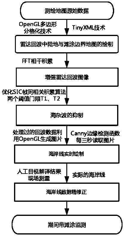
[0033] like figure 1 As shown, a multi-functional radar-based intertidal zone monitoring method includes the following steps.

[0034] Step 1, the drawing of the land and tidal flat boundary map in the radar echo: the drawing of the land and tidal flat boundary map in the radar echo is completed by using TinyXML technology and the OpenGL polygon gridding method.

[0035] In step 1, first, use TinyXML technology to extract the LineString element (route) and Polygon element (polygon) in the original data of the surveying map; then, use the latitude and longitude sample point interpolation technology to obtain the outermost closed boundary area in the actual map And the different road lines in the area; finally, use the OpenGL polygon grid technology to complete the boundary drawing.

[0036] Step 2, enhancing the radar echo ...


PUM


Abstract

The invention discloses an intertidal zone monitoring method based on a multifunctional radar, comprising the following steps: drawing a boundary map of land and tidal flat in radar echoes; enhancingradar echoes images; by optimizing the parameters of two thresholds T1 and T2 in the SIC inter-frame accumulation algorithm to suppress the sea clutter better, and generating a picture using the processed echo data by OpenGL; using the Canny edge detection function in OpenCV to read the current picture every three seconds and displaying a area of the current intertidal zone in real time. Accordingto the intertidal zone monitoring method based on multifunctional radar, drawing a boundary map of land and tidal flat is completed by using TinyXML technology and the OpenGL polygon separation method, the amount of calculation is greatly reduced, and a benchmark is given, which is easy to monitor; the parameters of two thresholds T1 and T2 in the SIC inter-frame accumulation algorithm are optimized to suppress the sea clutter better, the identifiability of the intertidal zone is increased; in addition, the area of the current intertidal zone can be displayed in real time, and the identification accuracy of the intertidal zone is improved.

Description

technical field [0001] The invention relates to the field of ocean remote sensing, in particular to a multi-functional radar-based intertidal zone monitoring method. Background technique [0002] Tidal flats are an important reserve land resource in China, with large area, concentrated distribution, good location conditions, and great potential for comprehensive development of agriculture, animal husbandry and fishery. important part. The general method of monitoring the coastline is to extract the coastline through remote sensing technology or a Gaofen-3 synthetic aperture radar. Although the accuracy is relatively high, the operation is difficult and the cost is high due to the long cycle. A multi-functional radar-based monitoring method for the intertidal zone can not only display the current intertidal zone area in real time, greatly shorten the cycle, but also work around the clock, which is of great significance for intertidal zone monitoring research. Contents of t...

Claims


Application Information

Patent Timeline
Patent Type & Authority Applications(China)
IPC IPC(8): G01S13/89
CPCG01S13/89
Inventor 赵呈树徐坤李凯邢晓勇李亚成
Owner 中船鹏力(南京)大气海洋信息系统有限公司
Why Eureka
Try Eureka