A method for estimating leaf area index of Ginkgo biloba plantation based on UAV lidar porosity model

A technology of leaf area index and laser radar, which is applied in the direction of radio wave measurement system, measurement device, image data processing, etc., can solve the problem of no acquisition, achieve the effect of enhanced ability and precision, low cost, and easy method transplantation

Inactive Publication Date: 2019-01-04
NANJING FORESTRY UNIV
View PDF3 Cites 6 Cited by
  • Summary
  • Abstract
  • Description
  • Claims
  • Application Information

AI Technical Summary

Problems solved by technology

However, most of the above methods are empirical model methods for estimating leaf area index, and most of them are aimed at natural forests in northern frigid and temperate zones in Europe and America.
At the same time, no UAV platform was used to obtain lidar data (to estimate forest leaf area index in a more flexible, efficient and low-cost way)

Method used


Image

  • A method for estimating leaf area index of Ginkgo biloba plantation based on UAV lidar porosity model
  • A method for estimating leaf area index of Ginkgo biloba plantation based on UAV lidar porosity model
  • A method for estimating leaf area index of Ginkgo biloba plantation based on UAV lidar porosity model

Examples


Embodiment 1

[0027] A method for estimating the leaf area index of ginkgo plantations based on the UAV lidar porosity model, the steps are as follows:

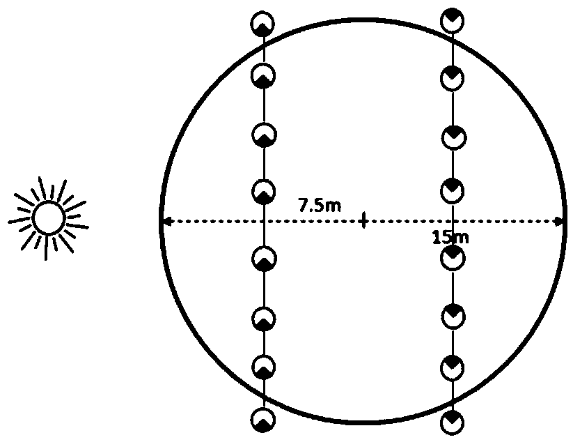
[0028] 1) Collect lidar point cloud data with the help of multi-rotor drones. Set up 45 circular plots within the test area, each with a diameter of 30m. The coordinates of the center point of the sample plot were measured using GPS (Trimble GeoXH6000), which positioned by receiving wide-area differential signals, with an accuracy better than 0.5m. And the leaf area index (eLAI) was measured by LAI-2200 in the sample plot. The measurement method is as follows:

[0029] Such as figure 1 As shown, two 30m measuring lines are selected in the direction perpendicular to the sunlight, and the midpoints of the two measuring lines are 7.5m away from the center of the circle respectively. In order to exclude the influence of ground cover, the LAI-2200 is placed at a position 1m above the ground for measurement. First, match the two probe rods ...


PUM


Abstract

The invention discloses a method for estimating leaf area indexes of Ginkgo biloba plantation based on a unmanned aerial vehicle (UAV) laser radar porosity model. The method comprises steps: 11) filtering and interpolating the discrete point cloud data of the lidar on the unmanned aerial vehicle to generate a digital terrain model, and normalizing the lidar point cloud data by using the generateddigital terrain model to obtain the normalized lidar point cloud data; 2) the Leaf area index (LAI) being estimated at plot scale by using a porosity model. The method for estimating the leaf area index of typical subtropical plain plantation by combining unmanned aerial vehicle (UAV) laser radar data with the porosity model method has the advantages of flexibility, rapidity, low cost, high quality and the like, and can better record the canopy structure characteristic of the forest and effectively enhance the inversion capability and precision of the leaf area index. The validation results show that the determination coefficient of LAI is increased by more than 5% compared with other similar remote sensing methods.

Description

technical field [0001] The invention belongs to the technical fields of forest resources monitoring, ecological factor investigation, carbon storage estimation and the like, and relates to a method for estimating the leaf area index of ginkgo plantations based on a UAV lidar porosity model. Background technique [0002] Rapid, real-time, and accurate estimation of plantation leaf area index and mastering its continuous spatial distribution are the prerequisites for sustainable plantation management and the basis for studying plantation carbon cycle. At the same time, this information plays an important role in the restoration and reconstruction of the ecological environment, the mitigation of global climate change, and the promotion of social and economic development. The traditional ground-based LAI measurement is mainly through direct method and instrument measurement, but the ground measurement is time-consuming, labor-intensive, inefficient, and can only obtain plot-scal...

Claims


Application Information

Patent Timeline
Patent Type & Authority Applications(China)
IPC IPC(8): G06T7/62G06T5/00G01S17/89
CPCG06T7/62G01S17/89G06T5/002G06T2207/10044G06T2207/30188
Inventor 曹林申鑫吴项乾刘坤代劲松汪贵斌
Owner NANJING FORESTRY UNIV
Why Eureka
Try Eureka