Downhole positioning method based on EIEL electronic labels

A technology of electronic tags and positioning methods, which is applied in positioning, earthwork drilling, radio wave measurement systems, etc., can solve the problems of low positioning accuracy, inability of the system to complete positioning services, and decision-making, and achieve high positioning accuracy, low cost, The effect of improving positioning accuracy

Active Publication Date: 2019-01-15
NORTH CHINA UNIVERSITY OF SCIENCE AND TECHNOLOGY
View PDF14 Cites 6 Cited by
  • Summary
  • Abstract
  • Description
  • Claims
  • Application Information

AI Technical Summary

Problems solved by technology

[0004] In recent years, with the development of wireless technology and the needs of the Internet of Things, radio frequency identification technology has been widely used, such as school electronic access control, parking lot positioning identification, logistics tracking, personnel positioning, item storage and management, intrusion detection, smart home, etc. On the one hand, most of them provide radio frequency identification services, and a small number of positioning services can only delineate an approximate location. The positioning accuracy ranges from more than ten meters to several meters. The Chinese invention patent application number 201410335966.0 discloses the underground positioning method of ZIgbee positioning technology, and the Chinese invention patent Application No. 201210137373.4 discloses a downhole positioning method based on RFID radio frequency identification. The positioning accuracy of this type of technology depends on the distribution density of signal receiving devices, and the positioning accuracy is not high, and the positioning process is completely dependent on power transmission and network reception. After the power supply is interrupted or the signal is interrupted, the system will not be able to complete the positioning service. Chinese invention patent application number 201610401387.0 discloses an underground positioning method combining geomagnetism and RFID radio frequency. Chinese invention patent application number 201710694907.6 discloses a method based on the joint distance These two methods are based on the geomagnetic characteristics of underground geomagnetic positioning methods, and there are few active RSSI positioning researches on the positioning equipment carried by personnel, especially the underground positioning method based on EIEL tags.

Method used


Image

  • Downhole positioning method based on EIEL electronic labels
  • Downhole positioning method based on EIEL electronic labels
  • Downhole positioning method based on EIEL electronic labels

Examples


Embodiment Construction

[0035] The present invention will be further described below in conjunction with the examples, the purpose is only to better understand the contents of the present invention, therefore, the examples given do not limit the protection scope of the present invention.

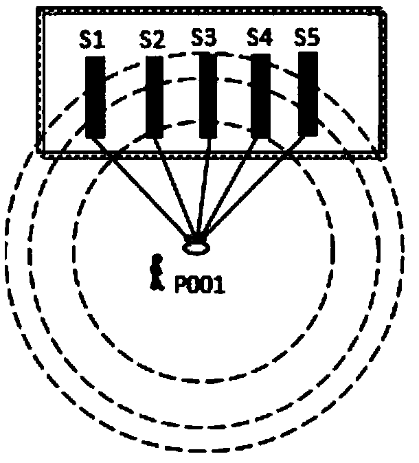
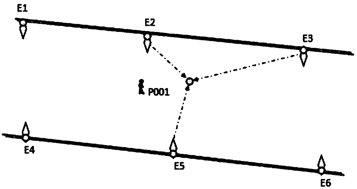
[0036] see figure 1 , figure 2 , image 3 , a kind of downhole location method based on EIEL electronic tag, comprises the steps:

[0037] Step 1, set the main parameters and specifications of EIEL electronic tags:

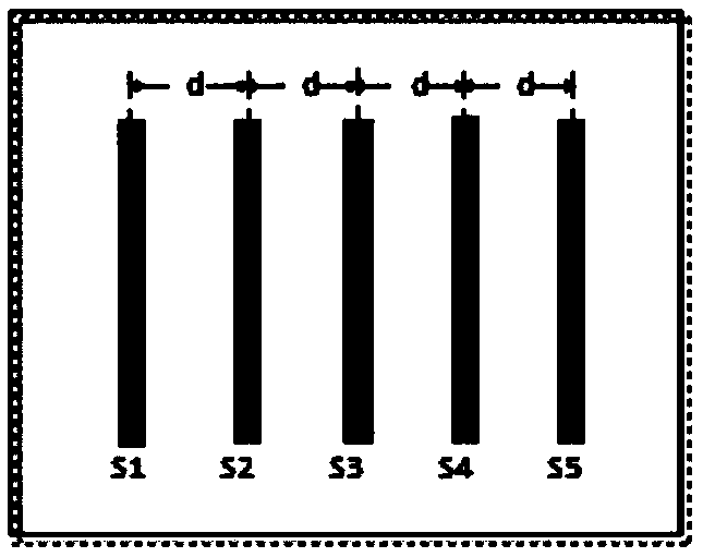
[0038] (a) In the experiment, the EIEL tags are arranged in an array of five strip-shaped passive radio frequency cards, and the distances between the radio frequency cards are all equal, 10 cm.

[0039] (b) Each RF card Si (i=1, 2, 3, 4, 5) stores the installation position coordinates (X, Y) and the main technical parameters of the RF card, the reference distance is d0, and the path loss index is n, See Table 1.

[0040] Table 1 Main information of E2 label

[0041]

[0042] Step 2, the posi...


PUM


Abstract

The invention relates to the technical field of downhole positioning, in particular to a downhole positioning method based on EIEL electronic labels. The downhole positioning method comprises the steps that the EIEL labels are equal-interval array-type electronic labels and are constituted by three to five band-shaped passive radio frequency cards S in an equal-interval array arrangement mode; positioning equipment is provided with a radio frequency identification sensor, after an equipment signal radiation field activates the peripheral EIEL labels, RSSI values and information of the radio frequency cards in the labels can be received, and current position coordinates are calculated according to an EIEL-Apositioning formula; the EIEL labels are distributed at the positions such as the junction of roadways, turn points and characteristic points of roadway topography transformation and distributed within 5-15 meters; and downhole personnel carry the equipment to walk in the roadways, the radiation field of the equipment can activate the two or more surrounding labels, and according to a space intersection method, average values are taken to calculate accurate coordinates. Accordingto the downhole positioning method, the manufacturing cost of the EIEL labels is low, large-range arrangement can be conducted in underground engineering or underground, information is provided for autonomous positioning and emergency risk-avoiding navigation of the downhole personnel, and the defects of an existing downhole positioning system are overcome.

Description

technical field [0001] The invention relates to the technical field of downhole positioning, in particular to a downhole positioning method based on an EIEL electronic tag. Background technique [0002] Underground positioning and emergency avoidance technology is the key guarantee for underground safety production and supervision and management. When a dangerous accident occurs in a mine, underground personnel or rescuers need to use positioning technology to accurately and quickly grasp the current exact location and carry out Locate navigation. Or combine the distribution information of the surrounding risk-avoiding facilities, use the positioning and navigation equipment to avoid the impact of the disaster, and determine the optimal path for your own escape or rescue. [0003] At present, the underground positioning system is generally installed underground mainly by using electromagnetic wave emission and signal identification methods to achieve underground positioning...

Claims


Application Information

Patent Timeline
Patent Type & Authority Applications(China)
IPC IPC(8): G01S5/04E21F17/18
CPCE21F17/18G01S5/04Y02D30/70
Inventor 汪金花李鸣铎郭云飞张博吴兵董元
Owner NORTH CHINA UNIVERSITY OF SCIENCE AND TECHNOLOGY
Why Eureka
Try Eureka