Method for characterizing spatio-temporal evolution of ground settlement
A technology of land subsidence and time-space evolution, which is applied in the direction of radio wave reflection/re-radiation, measuring devices, instruments, etc., to save time and economic costs, and reduce errors
- Summary
- Abstract
- Description
- Claims
- Application Information
AI Technical Summary
Problems solved by technology
Method used
Image
Examples
Embodiment 1
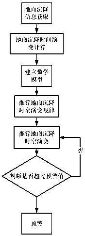
[0050] A method for characterizing the spatiotemporal evolution of land subsidence comprising the following steps:
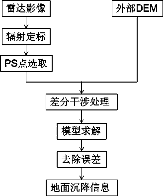
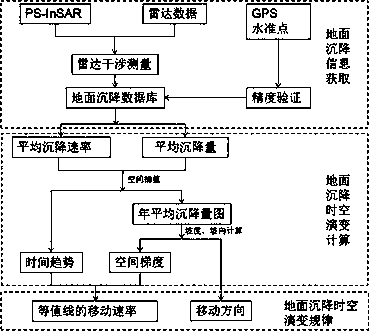
[0051] S1. Obtain the long-time sequence synthetic aperture radar observation image data covering the study area, assuming that the image acquisition time is t 0 ,t 1 ,...t n , using the permanent scatterer synthetic aperture radar interferometry (PS-InSAR) method to obtain the deformation information of each PS point on the surface, and to calibrate and verify the accuracy of the deformation data through on-site GPS and benchmark data to obtain high-precision stable PS points Vertical deformation database, which includes the annual mean settlement rate for each PS point v and the cumulative sedimentation of the observation time S 0 ,S 1 ,...S n ;
[0052] S2. Calculate the time trend and spatial gradient of regional land subsidence, and use the annual average subsidence rate for the time trend of PS point subsidence v To represent, using the Krigin...
Embodiment 2
[0080] In this program, the Radarsat-2 radar remote sensing images from 2010 to 2014 are processed by Sarproz software, and the accuracy of InSAR data results is verified by benchmarking point data to obtain high-precision land subsidence information. Taking the main subsidence funnel in Beijing as the research area, using the monitoring method to obtain the moving speed and direction of the land subsidence contour, and analyzing the temporal and spatial evolution of the land subsidence in the Beijing subsidence funnel area from 2011 to 2014. The main steps are as follows:
[0081] Step 1: Process the 39 scenes of Radarsat-2 data covering the Beijing plain area from 2011 to 2014 with Sarproz data processing software to obtain the land subsidence information in the Beijing plain area from 2011 to 2014, and use the monitoring data of six benchmarks in the study area Verify the accuracy of InSAR data results to obtain high-precision land subsidence information.
[0082] Step 2: ...
Embodiment 3
[0086] S1. Obtain the long-time sequence synthetic aperture radar observation image data covering the study area, assuming that the image acquisition time is t 0 ,t 1 ,...t n . Use the permanent scatterer synthetic aperture radar interferometry (PS-InSAR) method to obtain the deformation information of each PS point on the surface, and calibrate and verify the accuracy of the deformation data through on-site GPS and benchmark data to obtain high-precision vertical data of stable PS points. to the deformation database, which includes the annual mean settlement rate for each PS point v and the cumulative sedimentation of the observation time S 0 ,S 1 ,...S n .
[0087] S2. Calculate the time trend and spatial gradient of regional land subsidence. The average annual settlement rate is used for the settlement time trend of PS point v To represent, using the Kriging spatial interpolation method to obtain the regional spatial continuous mean annual subsidence rate rast...
PUM
 Abstract
Description
Claims
Application Information
 - R&D
- Intellectual Property
- Life Sciences
- Materials
- Tech Scout
- Unparalleled Data Quality
- Higher Quality Content
- 60% Fewer Hallucinations
Browse by: Latest US Patents, China's latest patents, Technical Efficacy Thesaurus, Application Domain, Technology Topic, Popular Technical Reports.
© 2025 PatSnap. All rights reserved.Legal|Privacy policy|Modern Slavery Act Transparency Statement|Sitemap|About US| Contact US: help@patsnap.com


