Method for estimating spatio-temporal change of remote sensing image, device and storage medium

A technology of remote sensing image and temporal and spatial changes, applied in the fields of structured data retrieval, instrument, character and pattern recognition, etc., can solve the problems of low efficiency, low degree of automation of manual interpretation, long time consumption, etc., and achieve the effect of high efficiency

Active Publication Date: 2019-01-18
GUANGZHOU URBAN PLANNING & DESIGN SURVEY RES INST
View PDF4 Cites 12 Cited by
  • Summary
  • Abstract
  • Description
  • Claims
  • Application Information

AI Technical Summary

Problems solved by technology

[0003] With the increasing accuracy, faster update frequency and better timeliness of urban remote sensing images, it has become an important data source for urban spatiotemporal change estimation; however, the traditional urban spatiotemporal change estimation methods mainly Including the method of manual comparison,

Method used


Image

  • Method for estimating spatio-temporal change of remote sensing image, device and storage medium
  • Method for estimating spatio-temporal change of remote sensing image, device and storage medium
  • Method for estimating spatio-temporal change of remote sensing image, device and storage medium

Examples


Embodiment Construction

[0037] The following will clearly and completely describe the technical solutions in the embodiments of the present invention with reference to the accompanying drawings in the embodiments of the present invention. Obviously, the described embodiments are only some, not all, embodiments of the present invention. Based on the embodiments of the present invention, all other embodiments obtained by persons of ordinary skill in the art without creative efforts fall within the protection scope of the present invention.

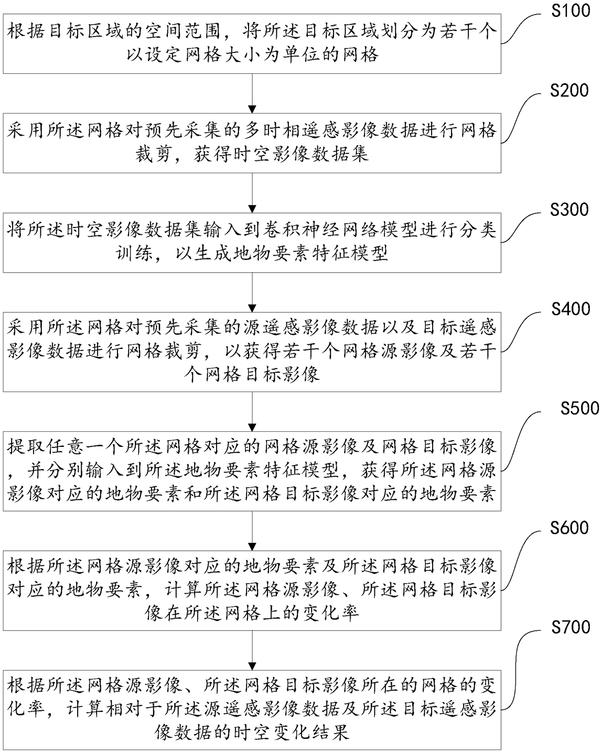
[0038] see figure 1 , which is a flow chart of a method for estimating temporal and spatial changes in remote sensing images provided by an embodiment of the present invention, the method for estimating temporal and spatial changes in remote sensing images includes:

[0039] S100: According to the spatial range of the target area, divide the target area into several grids with a set grid size as the unit;

[0040] The present invention can divide the spatial range...


PUM


Abstract

The invention discloses a method for estimating temporal and spatial change of remote sensing image, a device and a storage medium. The method includes: a target area is divided into a plurality of grids with a set grid size as a unit; the multi-temporal remote sensing image data are clipped by the grid, and the spatio-temporal image data set is obtained; CNN model is used to classify and train the spatio-temporal image dataset to generate feature model of surface features; the grid is used to cut the source remote sensing image data and the target remote sensing image data so as to obtain aplurality of grid source images and a plurality of grid target images; the features of the grid source image and the grid target image are extracted by the feature model of the features, and the differences are compared and analyzed to obtain the spatio-temporal change results of the target region. Through this method, the CNN and GIS technology can be highly integrated, and the automatic processing of urban spatial and temporal change estimation based on the massive urban remote sensing image data is realized, which has high efficiency.

Description

technical field [0001] The invention relates to the technical field of remote sensing image applications, in particular to a method, device and storage medium for estimating temporal and spatial changes of remote sensing images. Background technique [0002] Change estimation of remote sensing images is an important part of remote sensing image data processing and application. Change estimation is to qualitatively or quantitatively analyze and determine the characteristics and processes of surface changes from remote sensing images of different periods and ages. Estimation of urban temporal and spatial changes based on remote sensing images will play an important role in many fields, such as land use status investigation, land use planning compilation, urban overall planning compilation, urban change and management planning, natural resource investigation, and urban basic surveying and mapping. Updating of basic geographic databases, monitoring of ocean and inland water bodi...

Claims


Application Information

Patent Timeline
IPC IPC(8): G06K9/00G06K9/62G06F16/29
CPCG06V20/176G06F18/24
Inventor 张鹏程杨梅何华贵杨卫军郭亮周勍
Owner GUANGZHOU URBAN PLANNING & DESIGN SURVEY RES INST
Why Eureka
Try Eureka