Method for simulating GPS signal dynamic receiving environment and system thereof

A technology of GPS signal and simulation method, applied in the field of signal processing, which can solve the problems of low computational complexity and high theoretical complexity

Inactive Publication Date: 2019-02-15
NAT UNIV OF DEFENSE TECH
View PDF8 Cites 13 Cited by
  • Summary
  • Abstract
  • Description
  • Claims
  • Application Information

AI Technical Summary

Problems solved by technology

[0075] In view of the problem in the prior art that the theoretical complexity of the satellite signal incident direction estimation in the signal dynamic receiving environment simulation process is high, the purpose of the present invention is to provide a GPS signal dynamic receiving environment simulation method, which first calculates the real-time Attitude angle, so as to calculate the real-time incident direction of the signal satellite, with low computational complexity, which better satisfies the real-time performance of signal receiving analysis, and thus more reliably simulates the receiving signal in a dynamic environment

Method used


Image

  • Method for simulating GPS signal dynamic receiving environment and system thereof
  • Method for simulating GPS signal dynamic receiving environment and system thereof
  • Method for simulating GPS signal dynamic receiving environment and system thereof

Examples


Embodiment Construction

[0150] In order to facilitate the implementation of the present invention, further description will be made below in conjunction with specific examples, and a dynamic model is established by taking a quadrotor aircraft as an example.

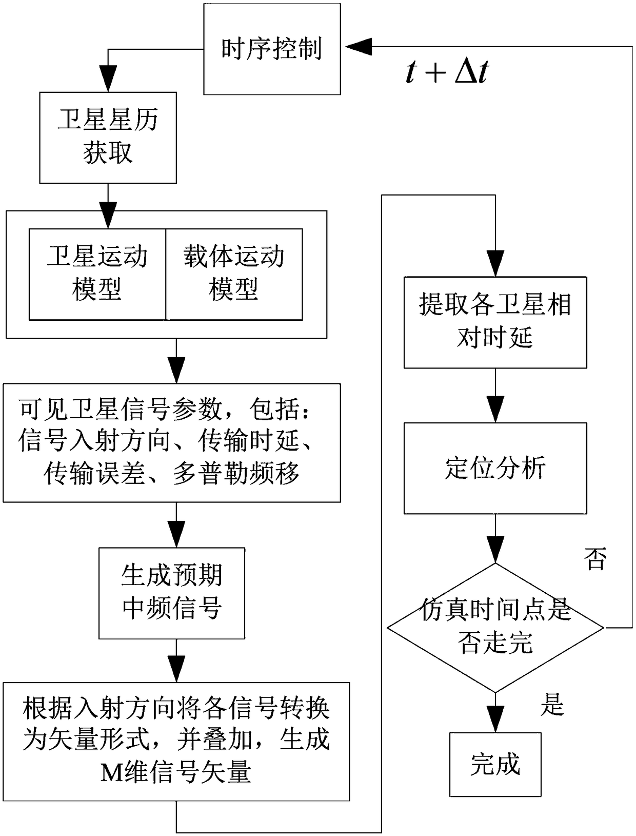
[0151] Such as figure 2 A kind of GPS signal dynamic receiving environment emulation method shown, specifically comprises the following steps:

[0152] S1. Read the satellite ephemeris and establish a satellite motion model according to the current moment

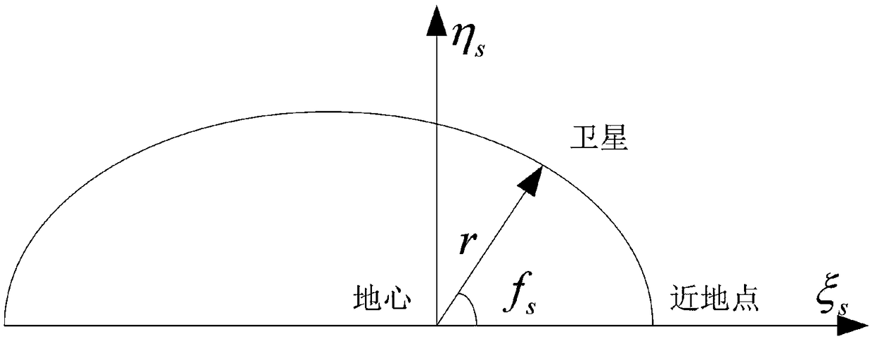
[0153] Download the navigation message in RINEX format from the website and read it with MATLAB. The satellite dynamic model is established with the navigation file in RINEX format. According to the existing technology theory, first calculate the real-time true anomaly and distance of the satellite, and establish a plane motion model; then convert the coordinates of the satellite in orbit to the ECEF coordinate system through the method of direction cosine transformation; finally correct t...


PUM


Abstract

The invention provides a method for simulating GPS signal dynamic receiving environment and a system thereof. The method comprises the following steps: reading satellite ephemerides and establishing asatellite motion model according to the current time; solving receiver carrier attitudes; calculating the incident direction of a satellite signal according to the receiver carrier attitudes and determining each visible satellite; calculating the transmission delay, the transmission error, the Doppler shift and the signal transmission error of the satellite signal; and generating an analog signal. The satellite motion model is established according to the satellite ephemerides, the receiver carrier attitudes are solved in the satellite motion model, and the incident direction of the satellitesignal is calculated by the solution structure of the receiver carrier attitudes. Finally, the transmission delay, the transmission error, the Doppler shift and the signal transmission error of the satellite signal are acquired to generate an analog signal. The method has simple calculation process and low complexity, and better realizes the real-time performance of signal reception analysis, thereby more accurately simulating the received signal in a dynamic environment. The method for simulating GPS signal dynamic receiving environment and the system thereof are applied to the field of signal processing.

Description

technical field [0001] The invention relates to the field of signal processing, in particular to a GPS signal dynamic receiving environment simulation method and system. Background technique [0002] Navigation signal generators play an important role in both military and civilian fields. Take the GPS signal generator as an example, such as Agilent's E4438C ESG vector signal generator and option 409GPS special software used by many research institutions. E4438C is a high-performance general-purpose RF signal generator that can provide a real-time high-precision test environment. Another example is the GSS4200 multi-channel GPS signal simulator developed by the British SPIRENT Communications Company, and the CCSG2200 satellite signal simulator developed by the American Computer Application Software Technology Co., Ltd. These GPS signal sources can simulate civilian coarse (C / A) codes and military precise (P) codes on GPS L1, L2 frequencies. However, foreign products are ex...

Claims


Application Information

Patent Timeline
Patent Type & Authority Applications(China)
IPC IPC(8): G01S19/13G06F17/50
CPCG01S19/13G06F30/20
Inventor 周柱张茂军刘煜
Owner NAT UNIV OF DEFENSE TECH
Why Eureka
Try Eureka